Trump may have edited Hurricane Dorian map with a marker to cover up his bad tweet

Misinformation and on-camera gaffes continue to plague Trump's administration, and they seem to have just one-upped themselves — with a Sharpie.
On Sunday, Trump falsely claimed that Hurricane Dorian was threatening Alabama in a tweet. Meteorologists confirmed that it wasn't, and — before statewide panic broke out over what the president called "one of the largest hurricanes ever" — the National Weather Service followed up with a subtweet to clear it all up.
"Alabama will NOT see any impacts from #Dorian," the National Weather Service in Birmingham, Alabama tweeted. "We repeat, no impacts from Hurricane #Dorian will be felt across Alabama. The system will remain too far east."
But Trump often refuses to backpedal on what he says, even if he's blatantly spreading false information. At the moment, Dorian is just off the coast of Florida and is expected to deliver "surge flooding, high winds, and flooding rain" to a large swath of the East Coast through Friday. But instead of offering support for the affected states in the hurricane's path — Florida, Georgia, South Carolina, North Carolina, and Virginia — the president doubled down on his fake Alabama claim.
During an "update" on the situation posted by the White House Twitter account on Wednesday, the president had Acting Secretary of Homeland Security Kevin McAleenan hand him a poster of the Southeastern U.S. highlighting Dorian's predicted path.
"Hopefully we're gonna be lucky, it depends what's gonna happen with South Carolina, North Carolina," he drawled.
But wait. Can we just zoom in and enhance on that map?
It appears that someone drew in an additional outline of the hurricane's path, extending it to cover ... Alabama.
It is a violation of federal law to falsify a National Weather Service forecast and pass it off as official, as President Trump did here.
18 U.S. Code § 2074: https://t.co/jvROnpSJLI pic.twitter.com/TnIuvZRJoS— Dennis Mersereau (@wxdam) September 4, 2019
Sharpie? Dry erase marker? Perhaps an off-brand version from Staples? Either way, that addition definitely looks hand drawn. And does not mesh at all with the actual path of the storm.
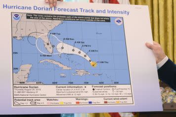
Image: jIM WATSON/ AFP / Getty Images
Multiple reporters say that when another reporter pointed out the map appears to be Sharpie'd, Trump brushed them off.
SEE ALSO: Why Twitter took action against parody Trump account @RealPressSecBot
Reporter just asked Trump about the map: "It looked like someone took a Sharpie...."
Trump: "I don't know. I don't know." (But Potus insists several times that Alabama was in the Dorian's path despite evidence to contrary.) https://t.co/2S92ndpnB1— David Nakamura (@DavidNakamura) September 4, 2019
REPORTER: That map you showed us today, it looked like it almost had like a Sharpie on it.
TRUMP: I don’t know, I don’t know, I don’t know. pic.twitter.com/d2oZemOshh— JM Rieger (@RiegerReport) September 4, 2019
And some meteorologists worried that this would only increase distrust in actual experts.
This is actually really serious. Because you know what this does? This erodes trust in people like the NHC or meteorologists in general. It politicizes a forecast. And that has dangerous implications among the 30% of the population that would follow this man off a cliff.
— Matt Lanza (@mattlanza) September 4, 2019
At least the jokes were good.
— Bierko (@VladBierko) September 4, 2019
If you aren't in Dorian's path, enjoy screaming into the void and consider helping those who are. If you are, here are some precautions to take. And if you're in Alabama, feel free to join in on screaming with the rest of the country.
UPDATE: Sept. 4, 2019, 4:04 p.m. PDT In a follow-up tweet Wednesday, the president posted a diagram showing Dorian's "originally projected path," which touches Alabama.
"I accept the Fake News apologies!" he said.
This was the originally projected path of the Hurricane in its early stages. As you can see, almost all models predicted it to go through Florida also hitting Georgia and Alabama. I accept the Fake News apologies! pic.twitter.com/0uCT0Qvyo6
— Donald J. Trump (@realDonaldTrump) September 4, 2019
But as New York Times national security editor Amy Ficus notes, the map is from the South Florida Water Management District and "warns that any maps from the National Hurricane Center or local emergency management officials 'supercede' it."
Here's the text from the bottom of the map:
Steve Lemongello, politics editor at the Orlando Sentinel, also pointed out that the map is from last Wednesday, before updated models predicted a turn in the storm's path. Trump's Alabama tweet is from Sunday.
Feel free to resume your screaming.
WATCH: Apple’s iPhone 11 event coming Sept. 10