Twin tornadoes create jaw-dropping scene in Colorado
- Oops!Something went wrong.Please try again later.
Wednesday was a disastrous day for severe weather in the central United States with a deadly twister in Matador, Texas, and a hectic hailstorm that injured concertgoers at Red Rocks Amphitheatre, an outdoor venue located 12 miles southwest of Denver.
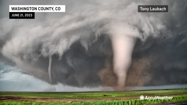
AccuWeather meteorologist and storm chaser Tony Laubach was in the right place at the right time to film the most eye-popping weather event of the day that unfolded south of Akron, Colorado, located about 100 miles east of Denver.
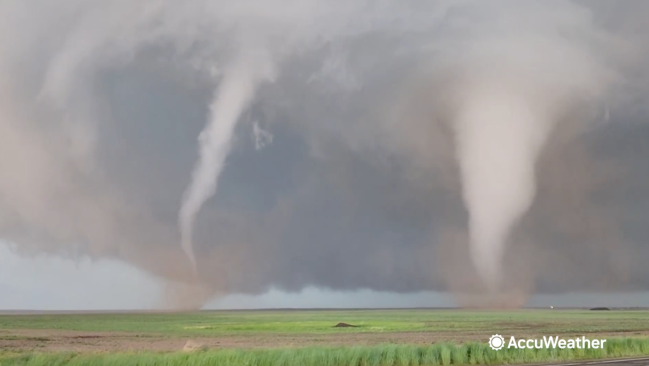
Twin tornadoes developed along a highway near Akron, swirling side-by-side in an open field. Initially, Laubach witnessed a single large cone tornado before the severe thunderstorm generated another smaller tornado. At one point, it appeared as though a third tornado was about to touch down before dissipating.
"[It was] one of the most incredible tornado sights I have witnessed, especially in the state of Colorado," Laubach said.
 |
Twin tornadoes spinning in an open field south of Akron, Colorado, on June 21, 2023. (AccuWeather/ Tony Laubach) |
Fortunately, the tornadoes swirled over an open area of eastern Colorado and did not hit any structures, according to Laubach. However, he added that some power poles were blown onto a road and an RV was overturned by strong winds associated with the tornado-producing thunderstorm.
An unusual weather pattern set the stage for the severe thunderstorms that erupted on Wednesday from Texas to Wyoming.
"We do not see storms of that caliber in this state because we are typically a drier climate," Laubach explained.
Dew points were near record levels in eastern Colorado, a key ingredient for the severe weather outbreak. The dew point is a temperature scale that helps forecasters analyze how much moisture is in the atmosphere. Dew points on Wednesday afternoon were in the 60s, providing ample moisture for the storms to tap into.
"It has been one of the more active days in Colorado we have seen in recent years," Laubach said.
The thunderstorms across eastern Colorado and southeastern Wyoming were prolific hail producers with hailstones measuring as large as baseballs in some locations.
Large hail was responsible for shattering vehicle windows during the severe weather, including at Red Rocks Amphitheatre where people scrambled for safety as a storm moved overhead on Wednesday evening.
Nearly 30,000 lightning strikes were also tallied over the region on Wednesday into Wednesday night, according to AccuWeather's database.
Additional rounds of severe thunderstorms are in the forecast for Colorado, Wyoming, Texas, Kansas, Nebraska and South Dakota through the end of the week.
Want next-level safety, ad-free? Unlock advanced, hyperlocal severe weather alerts when you subscribe to Premium+ on the AccuWeather app. AccuWeather Alerts™ are prompted by our expert meteorologists who monitor and analyze dangerous weather risks 24/7 to keep you and your family safer.
