Two tropical depressions could form this weekend. There’s another wave to watch, too
There are three disturbances being monitored in the Atlantic Friday and two have a high chance of turning into a tropical depression, possibly during the weekend.
None of the systems are currently a threat to Florida.
As of the 2 a.m. advisory Friday, the disturbance closest to the United States is about 100 miles southeast of the outer Banks of North Carolina, according to the National Hurricane Center.
While the system has become slightly better defined compared to Thursday, its associated showers and thunderstorms are still disorganized and well to the east of its center, according to the hurricane center.
Forecasters expect the system will turn into a tropical depression during the next day or so as it moves north to north-northeast off the U.S. coast.
It has a 70% chance of formation in the next two to five days.
“Regardless of development, this system could bring high surf to portions of the southeast and mid-Atlantic U.S. coasts through this weekend,” the hurricane center said.
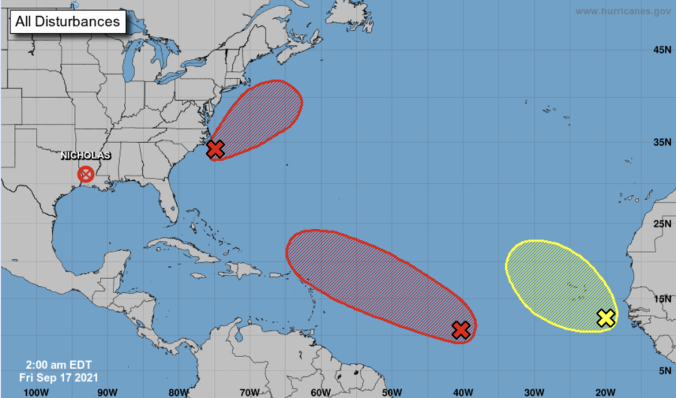
The other disturbance forecasters are closely monitoring was producing disorganized showers and thunderstorms in the eastern Atlantic early Friday, about 1,100 miles west-southwest of the Cabo Verde Islands.
Environmental conditions are expected to be conducive for development, with the system forecast to turn into a tropical depression over the weekend as it quickly moves west to west-northwest during the next several days.
Its formation chances in the next 48 hours are at 60% and 70% through the next five days.
Right behind it is a tropical wave that is producing disorganized thunderstorms a few hundred miles southeast of the Cabo Verde Islands. Forecasters say its chances of formation remain low, and if any development does occur, it would slowly happen during the next few days as the system moves west-northwest to northwest over the Atlantic.
It has a 10% chance of formation in the next 48 hours and 20% through the next five days.
As for the remnants of Nicholas, the hurricane center issued its final advisory on the system early Thursday. The Weather Prediction Center will continue to provide updates as long as the system remains a flood threat.
The next storm names on the list are Odette and Peter.

