Two disturbances forecast to emerge; could move in general direction of Caribbean
A dormant August stretch of storm activity in the tropics is set to conclude as the National Hurricane Center is forecasting two disturbances off the west coast of Africa.
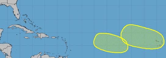
After a week and a half of quietude over the Atlantic Ocean, the 8 a.m. update Monday described one area of low pressure in the east-central Atlantic and another farther east.
Both systems initially have been given a low odds of developing over the next week, with one at 30% over the next seven days and the other at 20%. Both are expected to move in the general direction of the Caribbean, if the latest outlook holds.
As of early Monday, the potential system farther to the east had slightly better odds of developing. The area of low pressure was forecast to move off Africa and over the Atlantic Ocean on Wednesday or early Thursday, with slow development possible late in the week as it moves slowly west-northwest or northwest, forecasters said.
According to the 8 a.m. outlook Monday, the other area of interest, located closer to the central tropical Atlantic, was given 20% odds of developing in the middle to latter portion of this week over the east-central tropical Atlantic. It was expected to move slowly west-northwestward.
The next named storm would be Emily.
The National Hurricane Center is now predicting an “above-normal” 2023 hurricane season, increasing the likelihood from only a 30% chance in its last outlook to a 60% chance going forward.
The update announced Thursday comes as a result of ongoing record-breaking sea surface temperatures that continue to fight off the tempering effects of El Niño.
While sea surface temperatures have remained hot for longer than anticipated, El Niño’s effects, which typically reduce hurricane chances, have emerged more slowly.
The NHC, which operates under the National Oceanic Atmospheric Administration, is now calling for 14-21 named storms, including 6-11 hurricanes, and two to five major hurricanes.
