Two more rainstorms bring new dangers to California as officials tally widespread damage
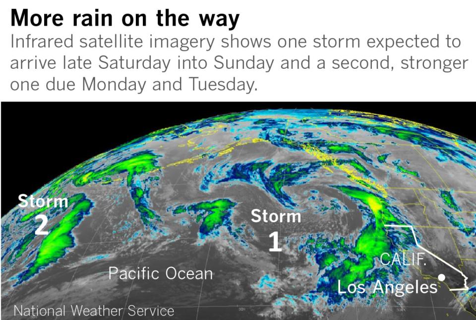
At least two more serious storms are headed toward California over the next few days, bringing more heavy rains and flash floods as communities tally the destruction from this week's punishing atmospheric river.
The new systems will hit parts of Northern California already saturated by rain and hammered by destructive winds.
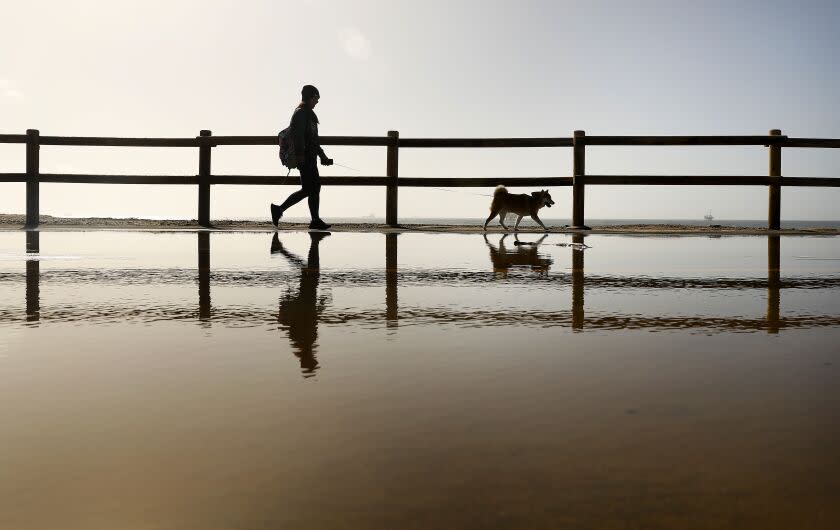
Coastal towns in Santa Cruz and Monterey counties were particularly hard hit by waves and flooding this week that damaged numerous homes and businesses and left beaches wrecked.
“I’ve been here for 17 years, and I’ve never seen anything like it," said Capt. Curtis Rhodes of CalFire's San Benito-Monterey unit. "We’ve never seen the waves this big.”
Fire officials responded to a home in Carmel breached by a wave he described as at least 50 feet high, which blasted out windows, ripped off a deck and filled the home with waist-deep water. He said a family was inside and got out safely.
Rhodes saw waves Thursday surpass the top of the famous lone cypress tree at Pebble Beach and go over parts of 17-Mile Drive, forcing the road to be closed.
“We’re not out of it yet," Rhodes said. "We’re ready for round three — just rehabbing our equipment, rehabbing our folks.”
Heavy rain and mountain snow was expected to begin late Friday night in Northern California, spreading to Central California on Saturday.
A more intense atmospheric river is expected to arrive over California on Monday, bringing damaging winds along with heavy precipitation. Flash flooding and debris flow are possible over recently burned areas. Officials warned about an increasing risk of avalanches as snow piles up in the mountains.
Officials were closely watching the potential threat of flooding from rivers across Northern California.
Along the coast, the Carmel and Salinas rivers in Monterey County could exceed flood stage, as could the Pajaro River, which flows down into Watsonville in Santa Cruz County. Parts of the Russian River, including Guerneville, could hit flood stage in Sonoma and Mendocino counties, as could the Navarro River south of the city of Mendocino and the Eel River in Humboldt County.
The Sacramento River could exceed flood stage in the coming days in Tehama, Glenn and Butte counties; the Tuolumne River in Modesto; Bear Creek in Merced; and Mokelumne River south of Sacramento.
The Cosumnes River, where at least three people were killed and found in or near their submerged cars after waters broke through levees in a recent storm, could reach levels like those of New Year's Eve. The deaths occurred in the vicinity of Highway 99, a major north-south route for the Central Valley, which was flooded by the storm.
Video by the California Department of Transportation showed a number of cars on New Year's Day flooded up to the bottom part of their windows on Highway 99.
During more recent storms, the California Highway Patrol shut the offramps at Dillard Road from Highway 99, around the area where two of the three bodies were found. "Avoid areas of Sacramento County that are susceptible to flooding," the CHP said.
“There is a lot of high water in a lot of places expected through Monday,” said Brett Whitin, a hydrologist with the California Nevada River Forecast Center. Part of the reason is that the ground is saturated, leading to more surface runoff into the rivers and creeks. The rivers are already swollen from previous rains.
“A lot of the river levels haven't really come down to the levels that they were, say, before the New Year’s Eve storm,” Whitin said.
Forecasters across the state called Friday a short reprieve from the onslaught of winter storms over the last week, which have flooded coastal and urban areas, triggered mudslides, downed trees, dumped heavy snow in the mountains and left at least five people dead.
Northern California has been hit the hardest in the recent storms, seeing flooding along the coast from massive waves and storm surge and waters rising across inland areas along creeks, streams and rivers — with more of that expected.
“We remain in a very wet pattern, well into next week," said Brooke Bingaman, a meteorologist with the National Weather Service in Monterey. She said it's been odd to look at the forecast and “not see much of a dry break anywhere, after having so much drought."
California's years-long drought has only exacerbated the impact of the latest string of storms, known as "atmospheric rivers," with trees more likely to topple, soils weakened and increased burn scars prone to landslides.
For Northern California, the brunt of the next storm should hit Saturday evening, before an even wetter system hits Monday during the day, Bingaman said. Then, she said, there's the potential for a third storm to move in toward the end of the week.
“We're still looking at a lot of rain," Bingaman said. "Because our soils are so saturated, any of these upcoming waves can be impactful because there’s just nowhere for the water to go."
Flooding, downed trees and power outages remain a concern heading into the weekend and next week, even as much of the state remains in recovery mode from the last storm — still dealing with dangerously high surf, thousands without electricity and other severe storm damage.
A high surf advisory was extended through Friday evening along Bay Area coasts, warning of dangerously large waves still crashing, up to 25 feet.
Images and videos from the last 48 hours showed significant damage in and around Santa Cruz County's coastline and at Carmel-by-the-Sea in Monterey County, from coastal flooding and damaged piers to an ocean-front home slammed by a massive wave and roads washed over with debris.
An evacuation order was still in effect Friday for Santa Cruz County's low-lying Capitola Village neighborhood, an area filled with restaurants and shops that saw severe flooding, not far from where a section of the city's pier collapsed during the storm Thursday.
As with the last storms, the worst of the outlook for flooding remains in Northern California over the next few days.
In the Bay Area, most urban regions saw 1 to 3 inches of rain over the last two days, while some areas in the Sonoma Mountains got up to 6 inches, Bingaman said. The Santa Cruz Mountains saw 3 to 4 inches, and the Big Sur coast recorded 3 to 6 inches.
In Sacramento, the previous storm produced about 2 to 4 inches in the foothill communities and about 1.5 inches to 2 inches in the Sacramento metro area. More rain is expected in the area this weekend.
“The main issue is the heavy rain leading to renewed flooding concerns,” said Scott Rowe, a meteorologist with the National Weather Service in Sacramento.
Here we go again! The next few days will feature multiple rounds of rain. Flood watch begins for the North Bay Saturday morning, expanding area-wide Saturday afternoon, lasting through Tuesday.
In addition to flooding, expect gusty winds, downed trees, and power outages.#CAwx pic.twitter.com/33Kh7hJflR— NWS Bay Area 🌉 (@NWSBayArea) January 6, 2023
Even with such high water levels, the state’s largest reservoirs remain at below-average levels after three years of severe drought.
As of Friday, Shasta Lake was at 35% of capacity and Lake Oroville was 41% full. Officials with the federal Bureau of Reclamation said they expect, based on the current five-day forecast, that Shasta Lake will rise about 20 feet in the coming days, taking in approximately 400,000 acre-feet of water. That amount of water, if spread out across Los Angeles, would cover the city more than 1 foot deep.
“If the longer-term forecast holds, those numbers will increase — possibly as much as double — over the following 10 days,” said Mary Lee Knecht, a spokesperson for the Bureau of Reclamation in Sacramento.
With the water deficit that California has accumulated over the last year, the latest data on the Drought Monitor website shows that much of the state is still considered to be in drought.
But in the latest update Tuesday, the portions of the state classified as being in "extreme" or “exceptional” drought shrank to 27%, down from 35% a week earlier. And the remaining areas of "exceptional" drought, which had been 7% of the state, disappeared from the map. The next series of storms is set to continue improving the state’s water outlook.
In Southern California, the last storm moved through faster and produced less rain than expected, delivering 1.5 to 3 inches overall, with 3 to 6 inches in the mountains and foothills, according to the National Weather Service.
The rainfall still created a number of issues for the region, including a mudslide along Topanga Canyon Boulevard in the Santa Monica Mountains that temporarily closed the road.
High surf combined with a high tide led to flooding in low-lying parts of the Long Beach peninsula Friday morning, with water flowing into the streets and multiple garages.
"Fortunately, many residents took proactive measures to protect their homes with sandbags," the Long Beach Fire Department said in a tweet.
A high surf warning was in effect through Friday evening for Orange County and San Diego beaches, with waves expected around 10 feet.
Many beaches in Los Angeles closed piers and warned residents of extreme surf conditions, at least through Saturday.
More intense rain is expected throughout California on Monday, bringing heavy rains along the coast and valleys up and down the state. Mountain and foothill areas are likely to be hit the hardest, meteorologists said.
Ryan Kittell, a meteorologist with the National Weather service in Oxnard, said this series of storms is stemming from a jet stream parked in the Pacific just south enough to keep Southern California in its track.
“We will be along the highway of storms for the next week or two,” Kittell said.
Staff writer Christian Martinez contributed to this report.
This story originally appeared in Los Angeles Times.

