Cold front spurs four tornadoes in South Florida followed by dropping temperatures
A bout of tenacious showers with shocks of damaging winds and multiple tornadoes plodded through Florida on Sunday shutting down the Daytona 500, canceling outdoor festivals and toppling rainfall records.
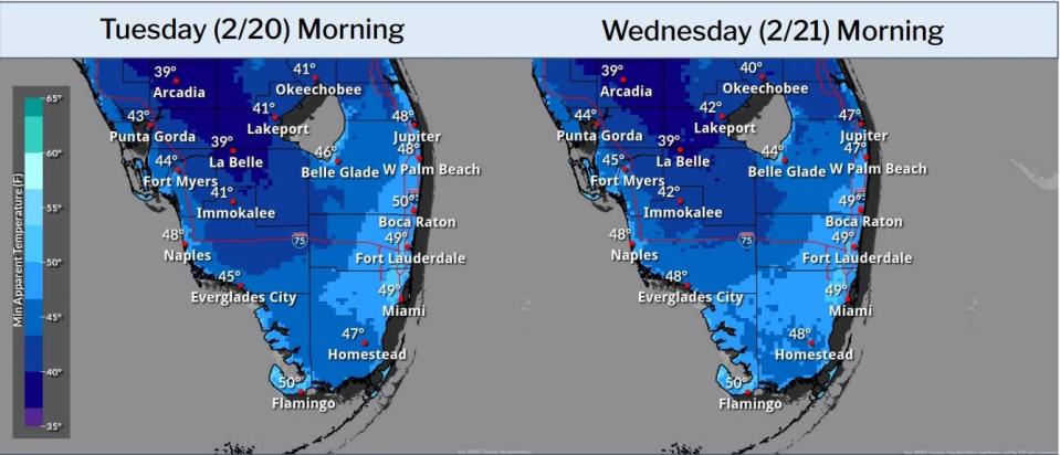
The slow-moving front, which will be followed by chilly mornings in the 40s and 50s into Thursday, broke decades-old rain records in Fort Lauderdale, Naples, and West Palm Beach with 2.74 inches falling at Palm Beach International Airport. That beat the previous record for that day of 1.6 inches set in 1920.
In Broward and Miami-Dade counties, National Weather Service meteorologists followed a broken trail of damage from what they believe to be a long-running funnel cloud that touched down multiple times on Sunday. A preliminary investigation found four tornadoes ripped through the two counties, flipping a car in Oakland Park and tearing limbs from trees. No injuries were reported, according to the NWS.
More: El Niño in Florida can mean rainy, cool dry season, but climate change may blunt the chill
NWS meteorologist Sammy Hadi, who is based in Miami, said although the rainfall was plentiful, it fell over a long period, which meant there was no flash flood threat.
“This frontal boundary stalled across the region and there was a lot of tropical moisture for it,” Hadi said. “It should clear (Monday) and we’ll see sunnier skies with highs in the 70s and lows in 50s for the rest of the week. It should be really beautiful.”
But northerly winds for most of this week mean seas as high as 12 feet in the Gulf Stream, a high risk of rip currents and potentially more erosion for Palm Beach County’s coast.
The worst loss of sand the county has seen in two decades has occurred at several hot spots as a strong El Niño pushes repeat cold fronts through the state, said Andy Studt, who manages the county’s coastal resources program.
“Tropical storms are our biggest impactors, but what we’ve seen this winter in the upper beach and dune regions is almost worse than some of the recent storm impacts,” Studt said. “We were in great shape going into September. This series of fronts has come as a bit of a surprise.”
Areas from Jupiter through Singer Island take the brunt of damage from waves driven by northerly winds. Studt said beaches hit hard this year include Coral Cove, areas south of Jupiter Beach Park, Jupiter Inlet Colony and parts of Singer Island.
In Jupiter Inlet Colony, officials are scrambling to shore up the beach in front of houses that have lost property to the ocean, including those of singer Kid Rock and Conair heiress Babe Rizzuto. On Singer Island, Studt said part of a retaining wall was lost and that some condominiums are putting up temporary sandbag-like barriers to reduce erosion.
“In the northern mile Singer Island, sea walls have increased from 30% to 75% in the past 20 years,” Studt said. “Those few properties that didn’t have them are now aggressively moving to get them.”
Typically, El Niño brings more rain in the winter months, and that power was on display Sunday.
Areas of Boynton Beach measured 3.14 inches of rain in the 24 hours ending at 7 a.m. Monday. Delray Beach got 3.28 inches and Boca Raton saw 3.57 inches. Farther south, Pompano Beach measured 4.06 inches.
NASCAR postponed the Daytona 500 to 4 p.m. Monday because of the foul weather that had winds gusting to 25 mph in Daytona Beach on Sunday.
Other events canceled or postponed by the rains included ArtiGras in Palm Beach Gardens, the final of the Delray Beach Open tennis tournament, and the Taste of Little Italy in Port St. Lucie.
Breezy northerly winds could push wind chill temperatures into the upper 40s at the coast through Wednesday with cooler “feels like” temperatures inland. No cold weather shelters had been announced in Palm Beach County as of early Monday. Cold weather sheltersgenerally open when temperatures of 40 degrees or lower, or wind chills of 35 degrees or lower, are forecast for periods of four consecutive hours or more.
Hurricane season: High chances La Niña will be here for peak season. That's not good news
The remainder of the week and into the weekend will be mostly clear as high pressure takes hold. High temperatures Tuesday and Wednesday will be in the low 70s with Thursday reaching near 75 degrees.
Friday will reach near 80 degrees before another cool front moves through South Florida on Saturday, dropping highs into the mid-70s with overnight lows in the mid-50s near the coast.
Kimberly Miller is a veteran journalist for The Palm Beach Post, part of the USA Today Network of Florida. She covers real estate and how growth affects South Florida's environment. Subscribe to The Dirt for a weekly real estate roundup. If you have news tips, please send them to kmiller@pbpost.com. Help support our local journalism, subscribe today.
This article originally appeared on Palm Beach Post: Cold front brought record rainfall and multiple tornadoes

