Two winter storms and a cold snap: What to expect from Seacoast weather this week
Two storms arriving in New England this week are projected to bring snow to Seacoast New Hampshire and southern Maine, followed by a cold snap that could drop wind chill temperatures below zero degrees.
Jon Palmer, a meteorologist with the National Weather Service in Gray, Maine, said forecasters are tracking a “relatively weak system,” the first of two storms this week, slated to enter New Hampshire and Maine on Tuesday and exit by Wednesday morning. Rain and very little snow is expected along the coastline in areas like Hampton, Rye, Portsmouth, Kittery and York, though some inland areas, such as Sanford, could see 3-4 inches of snow with 1-2 inches more likely in most inland areas of Rockingham, Strafford and York counties. Winds are unlikely to top 25 mph, Palmer said Monday.
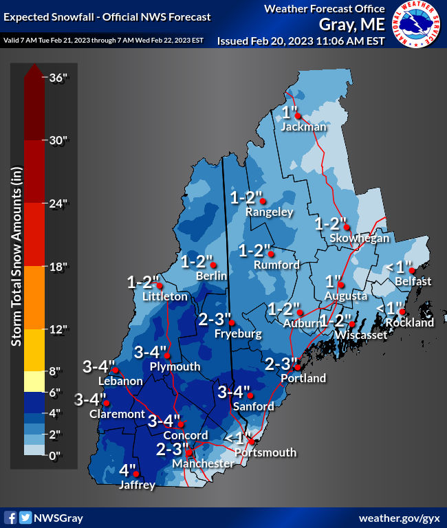
“If you live on the immediate coast, this could be a mostly rain event,” Palmer said. “The immediate coast should not see any measurable snow at all.”
Second storm of week is expected to be bigger
The storm set to reach the region on Wednesday night and carry into Thursday is expected to be more significant.
Though too far out to predict snowfall totals with precision, Palmer said, Thursday’s storm could bring 5-8 inches of snow to some areas in New Hampshire and Maine. The storm was hitting the Mountain West area to start the week before heading East.
“We expect everywhere along the Seacoast to have snow, and there will be some rain and snow and sleet mixing in through the day on Thursday,” Palmer said of the storm's local impact.
More local news:Old courthouse project in Dover. What we know about new apartments, rent rates, restaurant.
Seacoast communities, he added, could see anywhere from 4-6 inches, though other precipitation could alter those totals.
“It’ll all depend on how much sleet is mixing in as well,” Palmer said. “If we get a lot of sleet mixing in, our snow totals will be a lot less than what we were thinking.”
More local news:Portsmouth Naval Shipyard seeks 1,200 more workers, offers $5,000 bonus: How to apply
Cold snap on Friday and Saturday
By Friday, with the precipitation out of the way, a cold front creeping up behind the second storm could cause temperatures to dip considerably over the weekend, Palmer said.
Friday night into Saturday morning, temperatures could drop to single digits in the Seacoast and Strafford County. With Saturday morning expected to be the frostiest day this weekend, Palmer said wind gusts between 15-20 mph could cause Seacoast area wind chill temperatures to fall to single digits below zero and a few degrees colder in Strafford County.
The anticipated brief period of frigid temperatures could come just a few weeks after a historic cold snap caused burst pipes and sea smoke around the region.
“Just a quick minor cold snap then we’re back to where we have been,” Palmer said Monday of the current forecast. “But a lot can change.”
Snow on Sunday is a possibility, too, though the National Weather Service did not yet have detailed projections.
This article originally appeared on Portsmouth Herald: Snow, rain, sleet, cold snap: Seacoast NH, Maine weather forecast

