Lan moves into the southwest Sea of Japan after spreading intense rainfall


 |
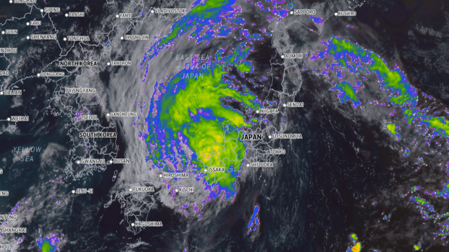
Lan swirled over Japan on Tuesday afternoon, local time, Aug. 15, 2023, as seen on the AccuWeather Enhanced RealVue™ Satellite. |
Tropical Storm Lan is tracking into the southwest Sea of Japan as of Tuesday evening, local time, and moving north of Japan's coast. AccuWeather meteorologists have been monitoring Lan for days and remain concerned about flooding rainfall and damaging winds the storm could bring to Japan.
Lan will continue to spread rain and wind from the Tottori to Fukui prefectures from Tuesday night into early Wednesday, local time. Numerous flights and train services were canceled during one of Japan's busiest travels seasons, Obon summer holiday, as the country prepares for direct impact from Lan, Reuters reported.
It was less than two weeks ago that Japan's Okinawa prefecture was pounded by former Typhoon Khanun, which killed at least two people and left thousands without power before carving a deadly path through South Korea. AccuWeather meteorologists are now tracking the current threat, Lan, which is poised to bring another round of wind and rain to Japan -- this time, closer to the country's capital of Tokyo.
Lan was transitioning into the Sea of Japan from the coast of the Hyogo Prefecture as of Tuesday night, local time. On the Saffir-Simpson Hurricane wind scale, Lan was equivalent to a Tropical Storm (maximum sustained winds of 39-73 mph, or 63-118 km/h). The cyclone was slowly tracking to the north.
At its peak strength Friday night, local time, Typhoon Lan swirled hundreds of miles south-southeast of Japan with wind intensity equivalent to a Category 3 major hurricane (maximum sustained winds of 111-129 mph, or 178-208 km/h) on the Saffir-Simpson Hurricane Wind Scale.
Despite the loss in wind intensity, Lan is expected to remain a formidable storm as it cruises into the Sea of Japan.
"Wind gusts to 60-80 mph (90-120 km/h) can impact areas from Tottori to Ishikawa, Gifu and Aichi prefectures Tuesday night into Wednesday, local time, with gusts to 40-60 mph (60-90 km/h) from Shikoku and Hiroshima and Shimane prefectures to Shizuoka and Niagata prefectures through Wednesday, local time. Wind gusts to 40-60 mph (60-90 km/h) are possible in northwest Honshu and western Hokkaido Wednesday into Friday, local times," explained AccuWeather Senior Meteorologist Jason Nicholls.
Such winds can result in structural damage, downed trees and power outages. Travel disruptions can continue to unfold as the storm moves to the north.
 |
High waves sweep to the bank due to Typhoon Khanun in Yoanbaru, Okinawa Prefecture on Aug. 2nd, 2023. (Keiichiro Azuma / The Yomiuri Shimbun via Reuters Connect) |
In terms of rainfall totals, amounts ranging from 4-8 inches (100-200 mm) can occur from Tottori to Fukui prefectures Tuesday night into early Wednesday, local time. Rainfall of 1-4 inches (25-100 mm) is expected from Shikoku and Hiroshima and Shimane prefectures to Nagano and Niagata prefectures into Wednesday, local time.
"Widespread flooding and mudslides can occur with these rains," Glenny said.
AccuWeather meteorologists are growing confident that Lan will have minimal rain and wind impacts in Tokyo. Latest indications point toward the capital city receiving little to no rainfall from the storm, but some gusty winds will hit there later Monday into Tuesday, local time, with the worst conditions remaining to the west-southwest along the coast.
Due to the impacts of heavy rain and strong winds, Lan has been rated a 2 on the AccuWeather RealImpact™ Scale for Tropical Cyclones in Japan.
Elsewhere across the West Pacific Ocean, Glenny noted that Dora, which contributed to the deadly wildfire flareup in Maui, Hawaii, crossed the international date line from the central Pacific and entered the West Pacific basin early this weekend, becoming known as a typhoon before losing wind intensity and transitioning to a tropical depression.
This is only the second time that a cyclone with winds of at least 74 mph (120 km/h) crossed over from the eastern to central to western Pacific since the satellite era. Hurricane John in 1994 was the other storm that survived the journey from the eastern to western Pacific, and up until Cyclone Freddy in 2023, it held the record for the longest-tracking tropical cyclone in the world.
"In the longer range, there is the potential for new tropical development south of Japan later in the week. This feature may end up being weaker than Khanun and Lan due to these storms churning up the oceans and lowering water temperatures in the area," Glenny said.
Want next-level safety, ad-free? Unlock advanced, hyperlocal severe weather alerts when you subscribe to Premium+ on the AccuWeather app. AccuWeather Alerts™ are prompted by our expert meteorologists who monitor and analyze dangerous weather risks 24/7 to keep you and your family safer.
