Typhoon Mawar – latest: Updates as Philippines braces for 175mph category 5 super cyclone
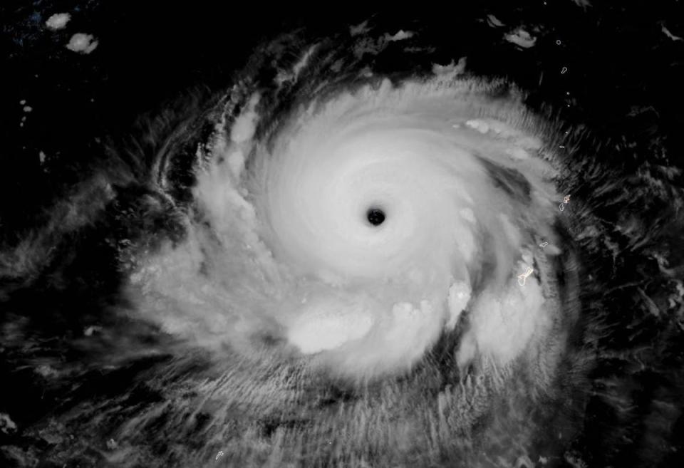
After a rapid intensification, Typhoon Mawar has become the most powerful storm of 2023 globally, according to the Joint Typhoon Warning Centre (JTWC).
Mawar’s peak winds have surged to 175 mph, accompanied by gusts nearing 210 mph, the JWTC said, as it heads towards the Philippines.
In its latest update, the state weather agency of the Philippines said Mawar has “slightly intensified while moving westwards over the Philippines sea”. This comes after the agency yesterday issued a notification that the cyclone has regained its status of a “super typhoon”.
The typhoon has also surpassed the strength of any storm recorded in 2022, experts say.
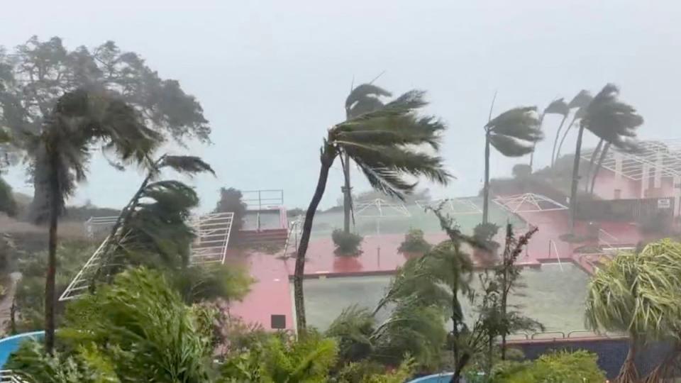
Typhoon Mawar’s intensification came after a brief weakening as it passed by Guam on Wednesday, lashing the island with heavy rains and winds that uprooted trees and blew away roofs and cars.
According to the Guam Power Authority, nearly all of the island’s 52,000 homes and businesses experienced power outages, with only 1,000 retaining electricity.
There are no reports of loss of life but extensive damage was reported, alongside localised flooding, fallen debris, and downed power lines.
Key points
Typhoon Mawar becomes 2023′s most intense storm
When will super Typhoon Mawar make landfall in the Philippines?
How strong is Typhoon Mawar?
Typhoon Mawar trajectory: Wich countries will be impacted?
Mawar 'may further intensify' says Philippines weather forecaster
Typhoon Mawar becomes 2023′s most intense storm
Friday 26 May 2023 06:13 , Stuti Mishra
After rapid intensification, Typhoon Mawar has become the most intense storm of 2023, according to the Joint Typhoon Warning Centre (JTWC).
Mawar’s peak winds have surged to 175 mph, accompanied by gusts nearing 210 mph, JWTC said.
The typhoon has also surpassed the strength of any storm recorded in 2022 and now stands equivalent to a category 5 super typhoon.
#Mawar now up to 150 knots (175 mph) per latest JTWC advisory.
Best I can tell, that's the planet's strongest #tropical cyclone (by est'd wind speed, with all usual caveats) since Dec. 2021 (ST Rai).
2022's strongest (wind speed) were all 140 knots (Ian, Noru, Hinnamnor). pic.twitter.com/ONkaa4Q72Q— Jonathan Erdman (@wxjerdman) May 25, 2023
These unprecedented wind speeds have brought the typhoon into the ranks of the five most powerful typhoons ever documented in the month of May.
Flash floods, surf warnings in effect
08:00 , Graig Graziosi
A surf warning was issued for Guam and the Northern Marianas ahead of Typhoon Mawar, according to the National Weather Service. The warning will continue through Saturday, and includes a risk of rip currents.
The agency also said there was the potential for heavy rains and flooding on Friday night in the region.
ICYMI: Typhoon Mawar hits Guam
07:00 , Graig Graziosi
Typhoon Mawar has made landing on the US territory of Guam, leaving extreme damage and power outages behind.
Andrea Blanco and Ariana Baio report:
Follow super Typhoon Mawar’s trajectory as storm heads for the Philippines
ICYMI: Identical twin meteorologists guide Guam through Typhoon Mawar
06:00 , Graig Graziosi
As typhoon Mawar aimed its fury at Guam, residents facing terrifying winds and crashing waves from the strongest storm to hit the US Pacific territory in decades had identical twin meteorologists to keep them informed — and to provide the outside world with a glimpse of the chaos unfolding on the remote island.

The identical twin weathermen protecting an island from a 140mph typhoon
Typhoon Odette vs Mawar: Most powerful typhoons to hit the Philippines
04:59 , Graig Graziosi
The Philippines is considered the most exposed country in the world to tropical storms as approximately 20 cyclones enter the Philippine Area of Responsibility (PAR), the area of the ocean the country monitors, yearly.
As the country once again prepares for the onslaught of this powerful cyclone, here are some of the strongest storms that have battered the country in recent times.
From Odette to Mawar: The most powerful typhoons to hit the Philippines
WATCH: Typhoon Mawar intensify into super typhoon
04:00 , Graig Graziosi
Will Typhoon Mawar hit Cebu?
03:00 , Graig Graziosi
Cebu, a port city in the Philippines, is bracing for a possible impact of typhoon Mawar as it heads towards the southeast Asian nation.
The typhoon is expected to reach the geographical region of the ocean monitored by the county, called the Philippines Area of Responsibility, tonight or tomorrow morning.
While there’s a “slim chance” of the typhoon, which has intensified greatly in the last few hours, making a direct landfall in the country, authorities are not ruling the possibility out.
The Cebu Port Authority (CPA) has activated its Incident Command System in preparation for the possible impact of Super Typhoon Mawar, according to local media reports.
The city authorities also shut down schools today and have suspended all ferry rides.
Some regions are expected to be lashed by heavy rains and winds even if the typhoon remains on its current path without moving its way towards the Philippines as feared.
‘We’re still here’: Guam residents get to repair as typhoon Mawar passes without a single death
02:00 , Graig Graziosi
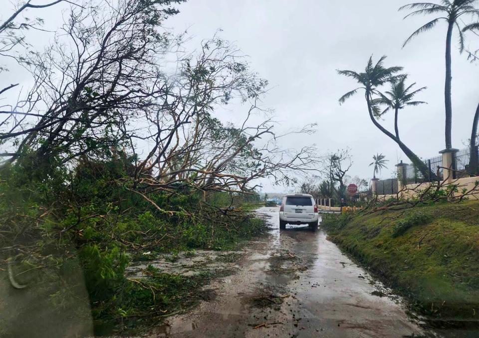
Chainsaws buzzed on Friday as neighbours helped each other clear toppled trees and began cleaning the wreckage of typhoon Mawar, which walloped Guam as the strongest typhoon to hit the island in over two decades.
While it was still early going in the recovery effort, Mawar appeared to have passed without leaving death or massive destruction in its wake.
“Guam has been very blessed to have no storm-related deaths or any serious injuries,” says a resident.
Read this dispatch from the remote US island:
Guam breathes sigh of relief as Typhoon Mawar leaves without single death
Alaska impacted by Super Typhoon Mawar
01:00 , Graig Graziosi
Parts of Alaska experienced “fetches of moisture” due to Super Typhoon Mawar, according to the National Weather Service (NWS) Anchorage.
The NWS in Anchorage tweeted on Thursday (25 May) showing satellite image of moisture patterns over the Pacific Ocean with Super Typhoon Mawar in the western Pacific Ocean.
Remnants of the storm were visible near the western coast of Alaska.
“Alaska is being impacted by back to back tropical fetches of moisture. Note that the second fetch is actually connected to Super Typhoon Mawar. This satellite image is from 18z or 10 am AKDT today!” NWS wrote.
Typhoon classification systems
Saturday 27 May 2023 00:00 , Graig Graziosi
In the Northwest Pacific Ocean, typhoons are classified based on their wind speed via the Japan Meteorological Agency (JMA) into three categories: typhoon, very strong typhoon and violent typhoon.
A typhoon is a tropical cycle that has sustained winds between 118-156 kilometers per hour. A very strong typhoon has sustained winds of 157-193 kilometers per hour. A violent typhoon has sustained wind speeds of over 194 kilometers per hour.
The National Oceanic and Atmospheric Administration classified typhoons into two categories: a typhoon or a super typhoon if sustained winds are over 241 kilometers per hour (150 mph).
Trajectory of Typhoon Mawar
Friday 26 May 2023 23:00 , Graig Graziosi
After parts of Mawar passed over Guam, the storm is now headed west toward the Philippines and Taiwain, further intensifying and threatening to bring heavy rains and gusts of wind.
Originating about 865km south of Guam, the typhoon battered the Pacific Island US territory on Wednesday.
It began moving westwards and is now expected to move toward the northern part of Luzon, Philippines and Taiwan.
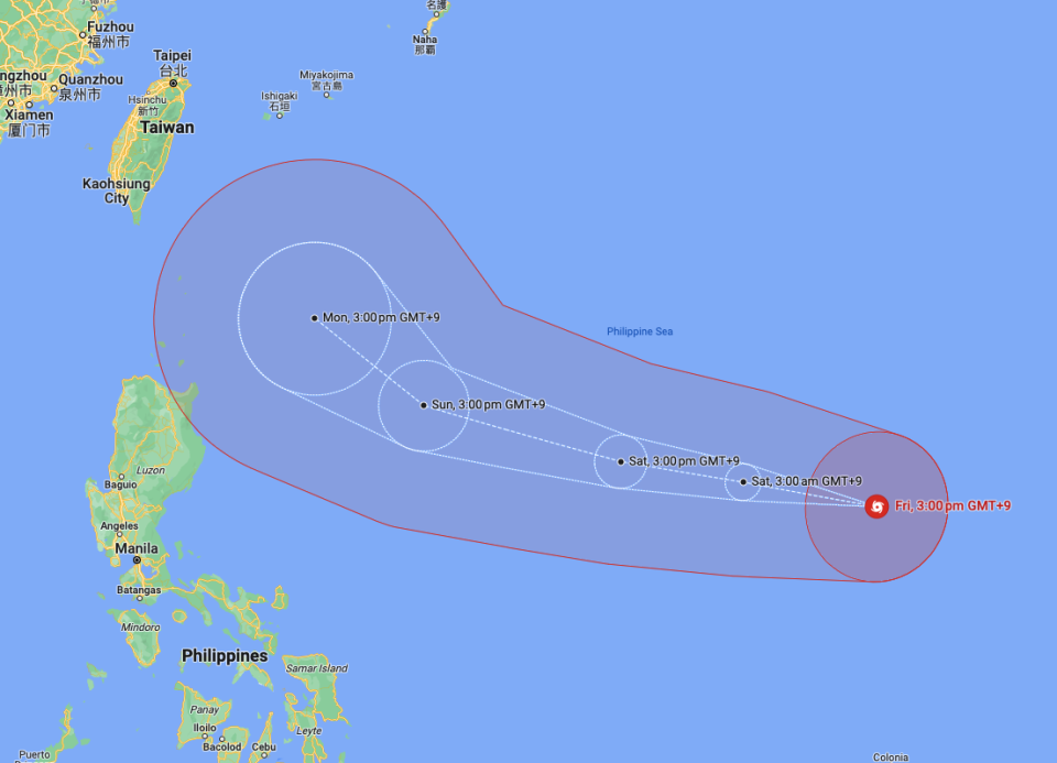
While the current projections show it may not make a direct landfall in the Philippines, the state weather agency PAGASA is not ruling out the possibility (See post below).
The weather agency said the storm can take a southern turn from its projected path and can make a landfall in the northern region of Luzon.
However, the chances of that happening are currently “slim”, according to Ana Clauren-Jorda, PAGASA weather specialist quoted by CNN Philippines.
It is currently located 622km west-northwest of Andersen Air Force Base, Guam, and has moved westward at 22kmh (12 knots) over the past six hours towards the Philippines Area of Responsibility (PAR).
However, the rapid intensification of the typhoon, after it weakened while it struck Guam, has worried experts with PAGASA stating it can reach its peak within the next 24 hours.
Jim Yang, a researcher at the China Meteorological Association, said in a Twitter post it was possible that parts of the typhoon would make landfall in China.
Mr Yang added that Mawar can “maintain high intensity for 2 to 3 days”.
Timelapse video shows Mawar rolling into Guam
Friday 26 May 2023 22:00 , Graig Graziosi
Time lapse video of #TyphonMawar in #Guam. You can see where the wind got strong enough to flex the window the GoPro was up against.#typhoon #Mawar #Mawarhitsguam #GoPro pic.twitter.com/51SD394uds
— The Salty Staff Officer (@MDMP_problems) May 25, 2023
CONTEXT: Hurricanes are getting stronger due to the climate crisis
Friday 26 May 2023 20:50 , Graig Graziosi
Super Typhoon Marwa is only the ninth storm of its kind since 1950 to reach a Category 5 status in the month of May — just one month into typhoon season.
To understand better how the climate crisis has made hurricanes and typhoons more powerful, read The Independent’s explanation below:
READ MORE:

Hurricanes are getting stronger. Here’s why
Photos capture the wreckage typhoon Mawar left behind in Guam
Friday 26 May 2023 20:08 , Graig Graziosi
Gambaran Guam diterjang angin marah mawar pic.twitter.com/z74h9zgZXd
— memeng 2 (@DambaanA) May 26, 2023
Mawar now called Betty as it enters Philippines monitor region
Friday 26 May 2023 19:26 , Graig Graziosi
Super Typhoon Mawar has crossed into the Philippines monitoring reigion, where it is now being referred to as “Betty” by monitors.
The Philippines uses its own names for typhoons that enters its “area of responsibility.”
The storm is a Category 5, but is not expected to make significant landfall in the Philippines at its current strength.
Mawar 9th typhoon since 1950 to reach Category 5 equivalent status in May
Friday 26 May 2023 18:09 , Graig Graziosi
Only eight other typhoons have reached a Category 5 status in May since 1950. Mawar will be the ninth.
Typhoon season typically lasts from April until December. Typhoons gaining a Category 5 equivalent status this early in the season are typically rare.
Simply jaw-dropping satellite imagery of Super Typhoon Mawar. pic.twitter.com/850iZSK2JE
— CIRA (@CIRA_CSU) May 25, 2023
WATCH: Detailed imagery showing super typhoon’s direction
Friday 26 May 2023 17:21 , Graig Graziosi
Stunning Super Typhoon #Mawar continues to track across the Philippine Sea. Forecasts are indicating that the typhoon will not strike the Philippines. More likely, Mawar will recurve and weaken east of Taiwan. pic.twitter.com/96a5zDg8aw
— Zoom Earth 🌎 (@zoom_earth) May 26, 2023
Super Typhoon Mawar may weaken as it approaches Philippines monitoring region
Friday 26 May 2023 16:37 , Graig Graziosi
The Maway super typhoon may weaken slightly on its westward approach to the Philipines.
The Philippine Atmospheric, Geophysical and Astronomical Services Administration issued an advisory noting that the storm would likely enter its monitoring region on Saturday, and predicted that the storm would slow over the course of the day.
The services said the storm will also weaken substantially on Monday.
“MAWAR is forecast to remain as a super typhoon tonight until the weekend, although the chance of slight weakening still remains,” PAGASA wrote. “However, this tropical cyclone may weaken at faster rate beginning on Monday during its slowdown period due to potential unfavorable conditions (e.g., effect of upwelling of cooler ocean water and dry air intrusion), although it is expected to remain as a typhoon by the end of the forecast period.”
TROPICAL CYCLONE ADVISORY NO. 6
Super Typhoon “MAWAR”
Issued at 11:00 PM, 26 May 2023
Valid for broadcast until the next advisory at 11:00 AM tomorrow.
SUPER TYPHOON “MAWAR” SLIGHTLY WEAKENS AS IT CONTINUES TO APPROACH THE PHILIPPINE AREA OF RESPONSIBILITY (PAR)
Location of… pic.twitter.com/QfDw11pb7x— PAGASA-DOST (@dost_pagasa) May 26, 2023
Jim Cantore shares satellite imagery of the enormous Mawar
Friday 26 May 2023 15:31 , Graig Graziosi
So this morning the sun is setting on a 180mph sustained #Mawar with gusts to 230mph! What a beast in the Pacific! Thank goodness this thing is not forecast to touch land. pic.twitter.com/OuBddKy4M0
— Jim Cantore (@JimCantore) May 26, 2023
Flash floods, surf warnings in effect
Friday 26 May 2023 14:48 , Graig Graziosi
A surf warning has been issued for Guam and the Northern Marianas ahead of Typhoon Mawar, according to the National Weather Service. That warning will continue through Saturday, and includes a risk of rip currents.
The agency also said there was the potential for heavy rains and flooding on Friday night in the region.
Typhoon Odette vs Mawar: Most powerful typhoons to hit the Philippines
Friday 26 May 2023 14:30 , Stuti Mishra
The Philippines is considered the most exposed country in the world to tropical storms as approximately 20 cyclones enter the Philippine Area of Responsibility (PAR), the area of the ocean the country monitors, yearly.
As the country once again prepares for the onslaught of this powerful cyclone, here are some of the strongest storms that have battered the country in recent times.
From Odette to Mawar: The most powerful typhoons to hit the Philippines
WATCH: Typhoon Mawar intensify into super typhoon
Friday 26 May 2023 14:00 , Stuti Mishra
Where will Typhoon Mawar land?
Friday 26 May 2023 13:30 , Stuti Mishra
Typhoon Mawar’s projected path shows the storm will be headed towards the Philippines, but not directly making a landfall as it moves north, away from the northern island
.While the state weather agency is not ruling out the possibility of a direct landfall, the cyclone is projected to move northwards, possibly impacting southern China and Taiwan.
According to Jim Yang, a researcher at the China Meteorological Association, the “the likelihood of Mawar making landfall” in China or Taiwan is increasing.
“If Mawar finally lands in Taiwan, it will become the first typhoon to land in Taiwan in May in 33 years; if it lands in Fujian, it will become the first typhoon in history to land in Fujian in May.”
Some computer models show Mawar turning away from the island towards the sea of Japan, where its strength may reduce after a few days as it encounters cooler waters.
However, the cyclone has been intensifying in the last few hours after it battered Guam. Philippines weather agency said it expects the typhoon to reach its peak intensity in the next 24 hours.
Will Typhoon Mawar hit Cebu?
Friday 26 May 2023 13:00 , Stuti Mishra
Cebu, a port city in the Philippines, is bracing for a possible impact of typhoon Mawar as it heads towards the southeast Asian nation.
The typhoon is expected to reach the geographical region of the ocean monitored by the county, called the Philippines Area of Responsibility, tonight or tomorrow morning.
While there’s a “slim chance” of the typhoon, which has intensified greatly in the last few hours, making a direct landfall in the country, authorities are not ruling the possibility out.
The Cebu Port Authority (CPA) has activated its Incident Command System in preparation for the possible impact of Super Typhoon Mawar, according to local media reports.
The city authorities also shut down schools today and have suspended all ferry rides.
Some regions are expected to be lashed by heavy rains and winds even if the typhoon remains on its current path without moving its way towards the Philippines as feared.
‘We’re still here': Guam residents get to repair as typhoon Mawar passes without a single death
Friday 26 May 2023 12:30 , Stuti Mishra
Chainsaws buzzed on Friday as neighbours helped each other clear toppled trees and began cleaning the wreckage of typhoon Mawar, which walloped Guam as the strongest typhoon to hit the island in over two decades.
While it was still early going in the recovery effort, Mawar appeared to have passed without leaving death or massive destruction in its wake.
“Guam has been very blessed to have no storm-related deaths or any serious injuries,” says a resident.
Read this dispatch from the remote US island:
Guam breathes sigh of relief as Typhoon Mawar leaves without single death
When will super Typhoon Mawar make landfall in the Philippines?
Friday 26 May 2023 11:50 , Stuti Mishra
Typhoon Mawar is heading towards the Philippines with sustained winds of 215kmh as the archipelago braces for heavy winds and rains over the weekend.
It was last spotted 1,705 kilometres east of southeastern Luzon, located over the Philippine Sea, moving west at 20 kmh, according to the Philippine Atmospheric, Geophysical, and Astronomical Services Administration (PAGASA).
It’s not yet clear whether the typhoon will make a direct landfall in the Philippines or not, but the state weather agency is not ruling the possibility out.
In its update on Friday, PAGASA said it expects Mawar to head west-northwest until Sunday and then turn northwest.
Mawar may slow down as it begins to move closer toward the waters east of extreme Northern Luzon, PAGASA said.
“The center of Mawar’s eye is forecast to be within 250 kilometres of the Batanes-Babuyan archipelago by next week during the slowdown period,” added the weather bureau.
The super typhoon is still on track to enter the geographical region observed by Philipinnes in the ocean, known as the Philippines Area of Responsibility (PAR) this evening or morning tomorrow.
Once inside PAR, it will be given the local name Betty.
Even if Mawar stays over water and does not make landfall in the Philippines, PAGASA says that it can still trigger heavy rain in Northern Luzon starting late Sunday or Monday, with a possibillity of floods and landslides.
Alaska being impacted by Super Typhoon Mawar
Friday 26 May 2023 11:00 , Ariana Baio
Parts of Alaska are experiencing “fetches of moisture” due to Super Typhoon Mawar, according to the National Weather Service (NWS) Anchorage.
The NWS in Anchorage tweeted on Thursday (25 May) showing satellite image of moisture patterns over the Pacific Ocean with Super Typhoon Mawar in the western Pacific Ocean.
Remnants of the storm can be seen near the western coast of Alaska.
“Alaska is being impacted by back to back tropical fetches of moisture. Note that the second fetch is actually connected to Super Typhoon Mawar. This satellite image is from 18z or 10 am AKDT today!” NWS wrote.
Alaska is being impacted by back to back tropical fetches of moisture. Note that the second fetch is actually connected to Super Typhoon Mawar. This satellite image is from 18z or 10 am AKDT today! #AKwx #Satellite #Mawar pic.twitter.com/9RTa8c1NQ3
— NWS Anchorage (@NWSAnchorage) May 25, 2023
Typhoon Odette vs Typhoon Mawar
Friday 26 May 2023 10:30 , Stuti Mishra
The Philippines, considered the most exposed country in the world to typhoons, is no stranger to the destruction of the storms.
In recent years, it has been repeatedly battered by heavy rains and destructive winds brought by typhoons that have left thousands dead and cost billions of dollars of damage.
As super typhoon Mawar now barrels to the archipelago, it is refreshing memories of the last strong typhoon the country was struck by, typhoon Odette.
Typhoon Odette, known outside of the Philippines as super typhoon Rai, was the second costliest typhoon in Philippine history behind Typhoon Yolanda.
It swept through 11 of the country’s 17 regions in December 2021, killing 410 people and leaving behind a trail of flattened homes, damaged farms, and other food sources, severely affecting people’s lives and livelihoods.

While typhoon Mawar has maximum one-minute sustained winds of 295kmh, typhoon Odette at category 5 scale recorded 280kmh of sustained winds.
Similar to Mawar, Odette also unexpectedly rapidly intensified into a category 5 super typhoon while approaching the Philippines.
Odette made landfall in the Philippines island of Siargao. While Mawar is expected to not make a direct landfall, the state weather agency PAGASA is not ruling out the possibility as the storm can take a southward turn from its projected path (see post below).
Typhoon classification systems
Friday 26 May 2023 10:00 , Ariana Baio
In the Northwest Pacific Ocean, typhoons are classified based on their wind speed via the Japan Meteorological Agency (JMA) into three categories: typhoon, very strong typhoon and violent typhoon.
A typhoon is a tropical cycle that has sustained winds between 118-156 kilometers per hour. A very strong typhoon has sustained winds of 157-193 kilometers per hour. A violent typhoon has sustained wind speeds of over 194 kilometers per hour.
The National Oceanic and Atmospheric Administration classified typhoons into two categories: a typhoon or a super typhoon if sustained winds are over 241 kilometers per hour (150 mph).
Trajectory of Typhoon Mawar
Friday 26 May 2023 09:34 , Stuti Mishra
After parts of Mawar passed over Guam, the storm is now headed west toward the Philippines and Taiwain, further intensifying and threatening to bring heavy rains and gusts of wind.
Originating about 865km south of Guam, the typhoon battered the Pacific Island US territory on Wednesday.
It began moving westwards and is now expected to move toward the northern part of Luzon, Philippines and Taiwan.
While the current projections show it may not make a direct landfall in the Philippines, the state weather agency PAGASA is not ruling out the possibility (See post below).
The weather agency said the storm can take a southern turn from its projected path and can make a landfall in the northern region of Luzon.
However, the chances of that happening are currently “slim”, according to Ana Clauren-Jorda, PAGASA weather specialist quoted by CNN Philippines.
It is currently located 622km west-northwest of Andersen Air Force Base, Guam, and has moved westward at 22kmh (12 knots) over the past six hours towards the Philippines Area of Responsibility (PAR).
However, the rapid intensification of the typhoon, after it weakened while it struck Guam, has worried experts with PAGASA stating it can reach its peak within the next 24 hours.
Jim Yang, a researcher at the China Meteorological Association, said in a Twitter post it was possible that parts of the typhoon would make landfall in China.
Mr Yang added that Mawar can “maintain high intensity for 2 to 3 days”.
Timelapse video shows Mawar rolling into Guam
Friday 26 May 2023 09:00 , Ariana Baio
Time lapse video of #TyphonMawar in #Guam. You can see where the wind got strong enough to flex the window the GoPro was up against.#typhoon #Mawar #Mawarhitsguam #GoPro pic.twitter.com/51SD394uds
— The Salty Staff Officer (@MDMP_problems) May 25, 2023
How strong is Typhoon Mawar?
Friday 26 May 2023 08:58 , Stuti Mishra
Typhoon Mawar's re-intensification over the last few hours has worried experts as it barrels its way towards the Philippines after battering Guam.
In an advisory issued by Philippines states weather agency PAGASA at 11am local time, it said Mawar now has maximum sustained winds of 215 kilometres per hour (kmh) near the centre, and gustiness of up to 260 kmh.
However, the storm is expected to intensify further, reaching its peak intensity within 24 hours, according to the PAGASA.
With the current wind speed, Mawar is equivalent to a category 5 hurricane. It was designated as a "violent typhoon" by the Japanese Meteorological Association yesterday.
Mawar is expected to bring heavy rains that may trigger flooding or rain-induced landslides over northern Luzon region of the Philippines by late Sunday or on Monday next week.
It is currently located 622 km west-northwest of Andersen Air Force Base, Guam, and has moved westward at 22 kmh (12 knots) over the past 6 hours towards the Philippines Area of Responsibility (PAR), according to satellite data.
NASA shares satellite image of Mawar over Guam
Friday 26 May 2023 08:00 , Ariana Baio
Mawar 'may further intensify' says Philippines weather forecaster
Friday 26 May 2023 07:30 , Stuti Mishra
The state weather agency of the Philippines said Mawar has “slightly intensified” while moving westwards over the Philippines sea”.
Mawar is moving westward at 20 kph and was last located 1,740 kilometres east of southeastern Luzon, PAGASA said in its latest update.
Weather forecaster Dan Villamil told CNN Philippines that Mawar is currently at 215 kph near the centre and gustiness of up to 265 kph.
However, its maximum sustained winds "may further intensify" to reach 220 kph, he noted.
This comes after the agency yesterday issued a notification that the cyclone has regained its status of a “super typhoon”.
Likelihood of Mawar making landfall in China increasing
Friday 26 May 2023 07:00 , Stuti Mishra
Jim Yang, a researcher at the China Meteorological Association indicated the likelihood that Typhoon Mawar makes landfall in China is increasing in a Twitter post.
“If it lands in Fujian, it will become the first typhoon in history to land in Fujian in May,” Jim Yang wrote.
Attached to the tweet was a photo of the predicted strike probability of Typhoon Mawar.
“If Mawar finally lands in Taiwan, it will become the first typhoon to land in Taiwan in May in 33 years.
More importantly for China, the likelihood of Mawar making landfall is increasing. If Mawar finally lands in Taiwan, it will become the first typhoon to land in Taiwan in May in 33 years; if it lands in Fujian, it will become the first typhoon in history to land in Fujian in May https://t.co/kUu1t2UpEJ pic.twitter.com/G4NPRWUkIT
— Jim yang (@yangyubin1998) May 25, 2023
In another post, the researcher said noting the increased intensity of Mawar: “What’s more difficult is that Mawar will maintain high intensity for 2 to 3 days.”
The intensity of Mawar has reached 160KT, which is the strongest typhoon in the Northwest Pacific in May! What's more difficult is that Mawar will maintain high intensity for 2 to 3 days, and T8.0 is expected to maintain for more than 24 hours! pic.twitter.com/9yfZ1KOTlo
— Jim yang (@yangyubin1998) May 26, 2023
No deaths reported in Guam
Friday 26 May 2023 06:00 , Ariana Baio
No deaths or significant injuries were reported in Guam after super Typhoon Mawar hit the island on Wednesday and Thursday, Governor Lou Leon Guerrero told CNN.
Though the typhoon did leave much of the island damaged with many residents without power or clean water.
As the storm hit Guam, its strength was equivalent to a Category 4 hurricane in the Atlantic with sustained winds of 140 miles per hour and gusts of up to 165 miles per hour.
Super Typhoon equivalent to a Category 5 hurricane
Friday 26 May 2023 05:00 , Ariana Baio
🌀 Super Typhoon #Mawar continues to chug westward with winds at 167 mph.
🇬🇺 Now more than 220 km away from Guam, Mawar is still going strong as a Category 5 storm with a distinct eye on satellite. pic.twitter.com/6fqG4wZX3k— MyRadar Weather (@MyRadarWX) May 25, 2023
Typhoon Mawar path
Friday 26 May 2023 04:00 , Ariana Baio
Typhoon Mawar has made landing on the US territory of Guam, leaving extreme damage and power outages behind.
Andrea Blanco and Ariana Baio report:
Eye of Typhoon Mawar makes landing in Guam before moving towards the Philippines
Parts of Guam without clean water
Friday 26 May 2023 03:00 , Ariana Baio
Parts of Guam are without clean water as of Thursday after Typhoon Mawar damaged water wells, pump stations and water treatment plants on parts of the island, according to reports.
The Guam Waterworks Authority asked residents to boil water due to possible bacterial contamination in the water until further notice.
Islandwide, resident are reporting water outages according to a report from the Guam Pacific Daily News. Specifically affected areas include Tamuning, Nimitz Hill, Agat, Santa Rita, Yona, Talofofo, Cross Island Road, Talofofo and Inarajan.
Guam Waterworks Authority General Manager, Miguel Bordallo, said there is no estimate for when service will be restored
“Reduced production capacity is unable to keep up with the demand, and therefore cannot rebuild reservoir levels,” Mr Bordallo told Guam Pacific Daily News.
Residents left with power cut and flood damage
Friday 26 May 2023 02:00 , Ariana Baio
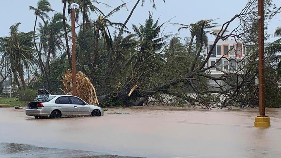
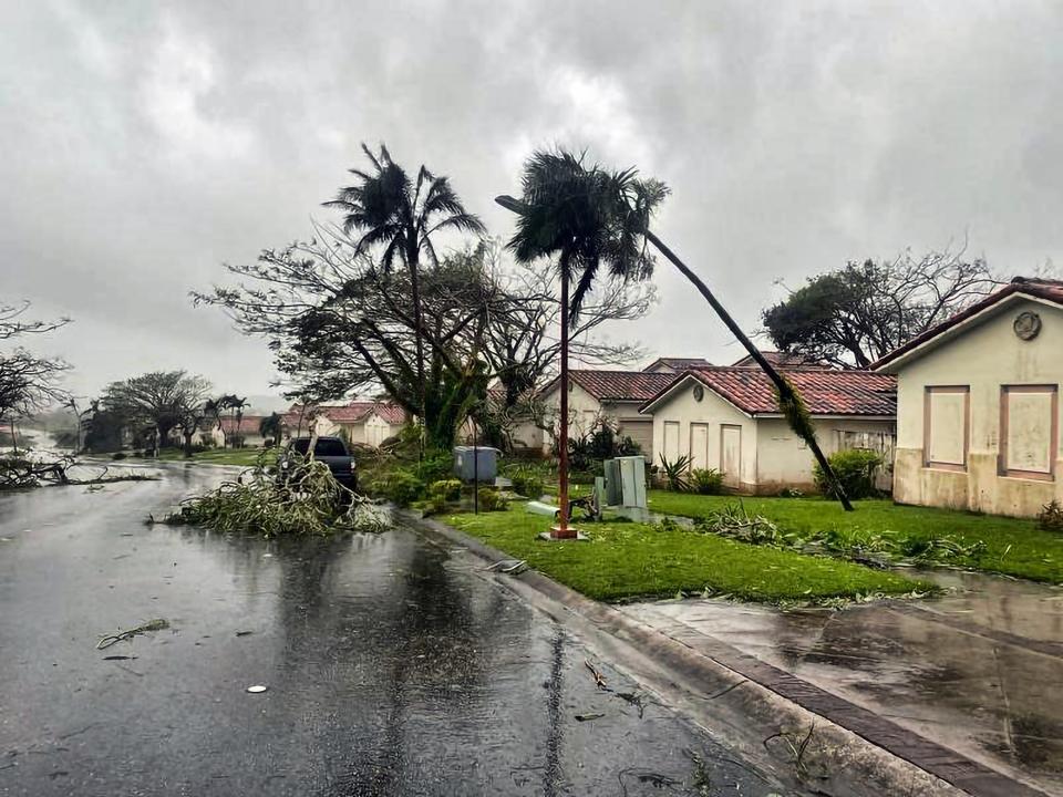
Guam successfully weathered the strongest storm in years as Typhoon Mawar swept across the Western Pacific Island last night.
Mawar made landfall at local time 9pm but the island was battered by heavy rains and powerful winds of up to 240 kph for hours yesterday, that uprooted trees, blew away roofs, and brought the US territory to a standstill.
According to the Guam Power Authority, nearly all of the island’s 52,000 homes and businesses experienced power outages, with only 1,000 retaining electricity.
Despite the intense conditions, the island managed to avoid significant damage.
There are no reports of unusual incidents in hospital emergency rooms, and the overall impact included moderate damages such as localised flooding, fallen debris, and downed power lines.
Identical twin meteorologists guide Guam through Typhoon Mawar
Friday 26 May 2023 01:00 , Ariana Baio
As typhoon Mawar aimed its fury at Guam, residents facing terrifying winds and crashing waves from the strongest storm to hit the US Pacific territory in decades had identical twin meteorologists to keep them informed — and to provide the outside world with a glimpse of the chaos unfolding on the remote island.
Identical twin meteorologists guide Guam through Typhoon Mawar
What is the difference between a typhoon and a hurricane?
Friday 26 May 2023 00:00 , Ariana Baio
Typhoons and hurricanes are from the same weather phenomenon known as a tropical cyclone, but the difference in names can sometimes confuse people.
According to the National Oceanic and Atmospheric Administration, the only difference between a hurricane and a typhoon is the location where the storm occurs.
If the storm is in the North Atlantic, central North Pacific or eastern North Pacific, it is called a hurricane.
If the storm occurs in the Northwest Pacific it is called a typhoon.
But in the South Pacific or Indian Ocean, generally, it is called a tropical cyclone.
Hurricanes are getting stronger. Here’s why
Thursday 25 May 2023 23:00 , Ariana Baio
Authorities in Guam warned anyone not living in a fully concrete house to head to safety elsewhere, and emergency shelters began to fill as residents braced for Super Typhoon Mawar, a powerful storm that delivered the biggest hit in two decades to the US territory in the Pacific.
As the global average temperature increases and sea levels rise, tropical cyclones - the catch-all term for hurricanes and typhoons - are expected to become stronger and the damage more catastrophic, scientists say. (In the Atlantic Ocean, hurricane season starts on 1 June.)
Louise Boyle and Ethan Freedman report:
Hurricanes are getting stronger. Here’s why
American Red Cross responds to Super Typhoon in Guam
Thursday 25 May 2023 22:30 , Ariana Baio
The American Red Cross said it was helping those affected by the Super Typhoon in Guam in a press release posted on Wednesday.
“The Red Cross has relief items on the island and staged in strategic locations in preparation for the storm, including water, shelf-stable meals, clean-up kits, tarps and hygiene supplies,” the Red Cross said.
“Nationally, a disaster leadership team is on Guam and as many as 200 trained disaster workers and more emergency supplies will be deployed to the island as soon as travel is possible.
The Red Cross will work with officials to coordinate the relief response, supporting sheltering and feeding operations, damage assessment and distribution of relief supplies.”
Mawar is strongest typhoon to hit Guam since 2002
Thursday 25 May 2023 22:00 , Ariana Baio
Super Typhoon Mawar is the strongest typhoon to pass near Guam, causing destruction and flooding, since Super Typhoon Pongsona in December 2002.
Super Typhoon Pongsona was equivalent to a Category 4 hurricane when the eye of the storm narrowly passed by Guam with 150 miles per hour winds.
#Mawar didn’t make landfall but the southern eyewall which was the strongest part of the storm, hammered the area, leading to #Guam’s 1st ever extreme wind warning. This is the closest pass of a major typhoon since Pongsona ‘02. Sadly, the radar is out so we won’t be able to get… pic.twitter.com/L86v0bVyvd
— Vortix ♦️CODE RED♦️ (@VortixWx) May 24, 2023
Dededo, Guam receives 22 inches of rain overnight
Thursday 25 May 2023 21:30 , Ariana Baio
At 6pm on Wednesday evening, Dededo, Guam had received 4.15 inches of rain as the island prepared for Super Typhoon Mawar to nearly make landfall.
By 6am on Thursday, Dededo recorded 26.8 inches of rain, according to USGS.
The storm approached Guam equivalent to a Category 4 hurricane, dumping rain and powerful winds on it.
Alaska being impacted by Super Typhoon Mawar
Thursday 25 May 2023 21:00 , Ariana Baio
Parts of Alaska are experiencing “fetches of moisture” due to Super Typhoon Mawar, according to the National Weather Service (NWS) Anchorage.
The NWS in Anchorage tweeted on Thursday (25 May) showing satellite image of moisture patterns over the Pacific Ocean with Super Typhoon Mawar in the western Pacific Ocean.
Remnants of the storm can be seen near the western coast of Alaska.
“Alaska is being impacted by back to back tropical fetches of moisture. Note that the second fetch is actually connected to Super Typhoon Mawar. This satellite image is from 18z or 10 am AKDT today!” NWS wrote.
Alaska is being impacted by back to back tropical fetches of moisture. Note that the second fetch is actually connected to Super Typhoon Mawar. This satellite image is from 18z or 10 am AKDT today! #AKwx #Satellite #Mawar pic.twitter.com/9RTa8c1NQ3
— NWS Anchorage (@NWSAnchorage) May 25, 2023
Super Typhoon Mawar: Worst storm to strike US Pacific in two decades barrels into Guam
Thursday 25 May 2023 20:31 , Ariana Baio
Typhoon Mawar has barrelled into Guam with hurricane-strength winds of up to 150mph, plunging residents into darkness.
The typhoon made landfall as a powerful Category 4 storm at around 9pm local time on Wednesday night, bringing with it heavy rains and a dangerous storm surge, the National Weather Service said.
Andrea Blanco and Rachel Sharp reports:
Typhoon Mawar, worst storm to strike US Pacific in two decades, barrels into Guam
Typhoon Mawar headed toward Taiwan and northern Philippines
Thursday 25 May 2023 20:17 , Ariana Baio
Super Typhoon Mawar is expected to move more north toward Taiwan and the northern part of Luzon, Philippines, according to predictions.
Around 8pm local time on Thursday, the centre of the storm was approximately 195 miles northwest of Guam, according to The New York Times.
The storm intensified to the equivalent of a Category 5 hurricane as it exited from Guam.
It is expected to lose intensity as it gets closer to Taiwan and the Philippines.
Typhoon Mawar is strongest storm of 2023
Thursday 25 May 2023 19:30 , Ariana Bio
So far this year, Typhoon Mawar is the strongest tropical cyclone to exist.
With 10-minute sustained winds of 121 miles per hour and gusts of up to 173 miles per hour, according to the JMA, the typhoon is equivalent to a category 5 hurricane at the moment.
Scenes from Guam show destruction from typhoon
Thursday 25 May 2023 19:00 , Ariana Baio
Videos and photos posted on Twitter show the destruction left behind by Typhoon Mawar in Guam.
The storm, which contained sustained wind speeds of 140 miles per hour and wind gusts of up to 165 mph, was equivalent to a category 4 hurricane.
Scenes from around Tumon Bay, #Guam the day after #typhoon #mawar - lots of tree damage, power and water out, hum of generators everywhere, immediate shoreline battered by surge and some cars shunted around by wind pic.twitter.com/BsSmcDV9He
— James Reynolds (@EarthUncutTV) May 25, 2023
Although no deaths or major injuries have been reported, thousands of Guam residents are left without power or water. Guam Water Authority and Guam Power Authority are working to restore power and water as quickly as possible.
Typhoon Mawar Aftermath ! Pray for Guam 🇬🇺 pic.twitter.com/IlBYssr3ho
— Ⓜ️ (@tr3_onmyback) May 25, 2023
WATCH: Typhoon Mawar intensify into super typhoon
Thursday 25 May 2023 18:30 , Ariana Baio
Typhoon classification systems
Thursday 25 May 2023 18:00 , Ariana Baio
In the Northwest Pacific Ocean, typhoons are classified based on their wind speed via the Japan Meteorological Agency (JMA) into three categories: typhoon, very strong typhoon and violent typhoon.
A typhoon is a tropical cycle that has sustained winds between 118-156 kilometers per hour. A very strong typhoon has sustained winds of 157-193 kilometers per hour. A violent typhoon has sustained wind speeds of over 194 kilometers per hour.
The National Oceanic and Atmospheric Administration classified typhoons into two categories: a typhoon or a super typhoon if sustained winds are over 241 kilometers per hour (150 mph).
Parts of Guam without clean water
Thursday 25 May 2023 17:30 , Ariana Baio
Parts of Guam are without clean water as of Thursday after Typhoon Mawar damaged water wells, pump stations and water treatment plants on parts of the island, according to reports.
The Guam Waterworks Authority asked residents to boil water due to possible bacterial contamination in the water until further notice.
Islandwide, resident are reporting water outages according to a report from the Guam Pacific Daily News. Specifically affected areas include Tamuning, Nimitz Hill, Agat, Santa Rita, Yona, Talofofo, Cross Island Road, Talofofo and Inarajan.
Guam Waterworks Authority General Manager, Miguel Bordallo, said there is no estimate for when service will be restored
“Reduced production capacity is unable to keep up with the demand, and therefore cannot rebuild reservoir levels,” Mr Bordallo told Guam Pacific Daily News.
Timelapse video shows Mawar rolling into Guam
Thursday 25 May 2023 17:00 , Ariana Baio
Time lapse video of #TyphonMawar in #Guam. You can see where the wind got strong enough to flex the window the GoPro was up against.#typhoon #Mawar #Mawarhitsguam #GoPro pic.twitter.com/51SD394uds
— The Salty Staff Officer (@MDMP_problems) May 25, 2023
Likelihood of Mawar making landfall in China increasing
Thursday 25 May 2023 16:30 , Ariana Baio
A researcher at the China Meteorological Association indicated the likelihood that Typhoon Mawar makes landfall in China is increasing in a Twitter post.
“If it lands in Fujian, it will become the first typhoon in history to land in Fujian in May,” Jim Yang wrote.
Attached to the tweet was a photo of the predicted strike probability of Typhoon Mawar.
“If Mawar finally lands in Taiwan, it will become the first typhoon to land in Taiwan in May in 33 years.
More importantly for China, the likelihood of Mawar making landfall is increasing. If Mawar finally lands in Taiwan, it will become the first typhoon to land in Taiwan in May in 33 years; if it lands in Fujian, it will become the first typhoon in history to land in Fujian in May https://t.co/kUu1t2UpEJ pic.twitter.com/G4NPRWUkIT
— Jim yang (@yangyubin1998) May 25, 2023
No deaths reported in Guam
Thursday 25 May 2023 16:15 , Ariana Baio
No deaths or significant injuries were reported in Guam after super Typhoon Mawar hit the island on Wednesday and Thursday, Governor Lou Leon Guerrero said to CNN.
Though the typhoon did leave much of the island damaged with many residents without power or clean water.
As the storm hit Guam, its strength was equivalent to a Category 4 hurricane in the Atlantic with sustained winds of 140 miles per hour and gusts of up to 165 miles per hour.
Pictures: Heavy winds, uprooted trees and residents heading for shelters as storm battered Guam
Thursday 25 May 2023 16:00 , Stuti Mishra


What is the difference between a typhoon and a hurricane?
Thursday 25 May 2023 15:30 , Ariana Baio
Typhoons and hurricanes are from the same weather phenomenon known as a tropical cyclone, but the difference in names can sometimes confuse people.
According to the National Oceanic and Atmospheric Administration, the only difference between a hurricane and a typhoon is the location where the storm occurs.
If the storm is in the North Atlantic, central North Pacific or eastern North Pacific, it is called a hurricane.
If the storm occurs in the Northwest Pacific it is called a typhoon.
But in the South Pacific or Indian Ocean, generally, it is called a tropical cyclone.
WATCH: Video shows winds picking up as Typhoon Mawar made landfall in Guam
Thursday 25 May 2023 15:00 , Stuti Mishra
Identical twin meteorologists guide Guam through Typhoon Mawar
Thursday 25 May 2023 14:30 , Stuti Mishra
As typhoon Mawar aimed its fury at Guam, residents facing terrifying winds and crashing waves from the strongest storm to hit the US Pacific territory in decades had identical twin meteorologists to keep them informed — and to provide the outside world with a glimpse of the chaos unfolding on the remote island.Read more:
Identical twin meteorologists guide Guam through Typhoon Mawar
Typhoon Mawar to be named 'Betty' once it reaches Philippines
Thursday 25 May 2023 14:00 , Stuti Mishra
Typhoon Mawar, which is heading towards the Philippines now after battering Guam, will be given the local name "Betty", once it enters the Philippines Area of Responsibility (PAR), local officials have said.
Mawar is currently packing winds of up to 185 kilometres per hour near the centre and gusts of up to 230 kph as it moves west-northwestward at 15 kph, according to Philippines state weather agency.
It is expected to pass close to the northern Philippines tomorrow night or on Saturday.
Typhoon Mawar now a 'violent typhoon'
Thursday 25 May 2023 13:30 , Stuti Mishra
The Japan Meteorological Agency (JMA) has upgraded Mawar into a “Violent Typhoon”, a category stronger than super typhoon.
The agency said the typhoon now has 10-minute sustained winds of 195 kmh with gusts of 280 kmh.
BREAKING: STY #Mawar is now a VIOLENT typhoon by RSMC Tokyo, with 10-min sustained winds of 105 kts (~195 km/h), and a pressure of 920 hPa.
It is now officially the third most intense tropical cyclone in the Western Pacific basin formed in the month of May since records began in… pic.twitter.com/MazS3KupPE— Matthew Cuyugan (@MatthewCuyugan) May 25, 2023
A violent typhoon is the highest category used by the JMA to classify tropical cyclones.
'Like a freight train going on outside': Residents describe overnight horror as Typhoon Mawar passed
Thursday 25 May 2023 13:00 , Stuti Mishra
Residents in Guam were battered by heavy winds and rains all throughout the day yesterday. But as the strongest typhoon to hit the territory crept slowly over the island at night, the horror intensified.
The winds sent solar panels flying, ripped roofs off homes and crumbled part of a hotel's exterior wall to the ground, according to videos posted on social media.
At what felt like its peak intensity, the winds screeched and howled like jets, and water swamped some homes, residents say.
Leah del Mundo, who spent the night with her family in their concrete home in Chalan Pago, in central Guam told The Associated Press they tried to sleep but were awakened "by violent shaking of the typhoon shutters and the whistling strong winds."
"It's not our first rodeo," she told the news agency via text message. "We've been through worse. But we brace ourselves for the cleanup, repairs, restoration afterwards."
Winds peeled back the roof of Enrique Baza's mother's house in Yona, allowing water to damage everything inside.
“My mom’s house didn’t escape.”
Enrique Baza
"My mom's house didn't escape," he said, adding that his mother stayed with him in his concrete home during the storm.
He drove around in a pickup truck looking for supplies to repair his mother's roof, but most stores were without power and only accepting cash. Many wooden or tin homes he passed were badly beaten or collapsed.
"It's kind of a shock," he said.
In Tumon, on Guam's northeastern shore, winds tore a granite countertop from a hotel's outdoor bar and tossed it into the air. Guests scrambled to stack chairs to brace the doors, and windows buckled and creaked.
"It was like a freight train going on outside," said Thomas Wooley, who recounted how wind and rain pushed through the aluminium shutters of his family's concrete home overlooking Tumon Bay.
When day broke, he found their outdoor china cabinet toppled and its contents shattered on the ground. A chainsaw-wielding relative helped clear downed branches.
"We've got tons of work to do," Mr Wooley said.
Guam's weather service office in Tiyan said it would shut down operations in the morning for workers to get home to families and assess damage at their homes. Counterparts in the Honolulu office took over their duties.
In photos: Flooded homes, flipped vehicles and shredded trees as Guam residents begin cleanup
Thursday 25 May 2023 12:30 , Stuti Mishra


Typhoon Mawar ‘reintensifies’ to super typhoon as it heads to Philippines
Thursday 25 May 2023 08:00 , Stuti Mishra
Mawar has “re-intensified” into a super typhoon as it now heads to the Philippines, the state’s weather service said after a brief weakening of the storm after it passed over Guam.
The cyclone is currently packing winds of up to 185km per hour near the centre and gusts of up to 230kph as it moves west-northwestward, according to the Philippine Atmospheric, Geophysical and Astronomical Services Administration (PAGASA).
The typhoon passed through Guam yesterday which successfully weathered the storm, believed to be the strongest storm in years to hit the Western Pacific Island.

