Mawar reintensifies into super typhoon after slamming Guam


Mawar has intensified once more into a super typhoon after AccuWeather forecasters say Guam had an incredibly close brush with the powerful storm on Wednesday. The center of the storm, then just a typhoon, had bore down on the U.S. territory and unloaded a deluge of rainfall, unleashed destructive winds and knocked out power to nearly the entire island.
On Wednesday afternoon, local time, only 1,000 out of the 52,000 customers on the island had power, the Guam Power Authority confirmed in a statement.
"Almost all of our circuits have been impacted and [are] without power," utility officials said. The utility company posted an update on Thursday evening, local time, asking for the public's patience amid the "extremely dangerous effort" of power restoration.
Power restoration efforts were delayed early Thursday as crews took shelter from the storm's potent winds. In a Thursday afternoon update, the Guam Power Authority noted that engineers had begun to conduct damage assessments and make repairs.
Guam is home to about 168,000 people, including more than 20,000 United States military personnel and dependents.
A spokesperson for the American Red Cross said in an email to AccuWeather on Thursday that "the vast majority of Guam is currently without power, including hospitals, which are running on generators. Guamanians are resilient, hoping for the best!"
A national Red Cross disaster leadership team is on Guam and as many as 200 trained disaster workers and more emergency supplies will be deployed to the island as soon as travel is possible, according to a Red Cross update posted on Wednesday.
The typhoon made its closest approach to Guam around 5 p.m., local time, Wednesday. Mawar's eye managed to avoid direct landfall and thread the needle between Guam and the island of Rota just to the north.
 |
Typhoon Mawar made its closest approach to Guam on Wednesday, May 24. (CIRA/RAMMB) |
"The southern edge of Mawar's eyewall brushed the northern coast of Guam, and it did not technically make landfall," explained AccuWeather Lead International Forecaster Jason Nicholls. Typically, the center of a storm's eyewall has to cross over land for landfall to be declared.
• Have the app? Unlock AccuWeather Alerts™ with Premium+
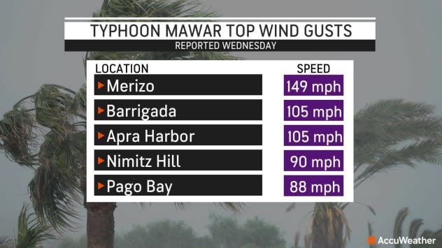
While there was no landfall, the eyewall is typically home to a cyclone's strongest and most destructive winds. A wide swath of winds ranging from 90-110 mph (145-180 km/h) with some locally higher gusts pounded the northern portion of the island for a considerable time on Wednesday.
The high winds tore roofs off of buildings, snapped trees like toothpicks and flipped over vehicles. Officials report minor injuries as a result of the storm but there have been no confirmed fatalities.
 |
Before bearing down on Guam, the Joint Typhoon Warning Center declared Mawar a super typhoon for a time on Tuesday. The storm lost that designation around the middle of the week before regaining it on Thursday, local time.
At its closest approach, Mawar fluctuated in strength between a Category 3 major hurricane (sustained winds equivalent to 111-129 mph or 178-208 km/h) and a Category 4 major hurricane (sustained winds equivalent to 130-156 mph or 209-251 km/h) on the Saffir-Simpson Hurricane Wind Scale.
The National Weather Service office in Guam put an extreme wind warning into effect for the northern half of the island for several hours on Wednesday. In the warning text, the NWS urged residents to "treat these imminent extreme winds as if a tornado was approaching."
The typhoon's strong winds also knocked out radar capabilities and imagery for the island as the storm raged on Wednesday. NWS forecasters in Guam confirmed on Twitter Wednesday evening that they had "lost communication with the radar."
 |
A satellite loop of Mawar churning west of Guam late Thursday, local time. (AccuWeather) |
Although the typhoon's closest approach unfolded on Wednesday, torrential rainfall and destructive winds began earlier in the week.
Between Tuesday and Wednesday, local time, more than a foot of rain (300 mm) had fallen across portions of Guam. An observation in Dedeo, located on the northern end of the island, showed more than 27 inches (680 mm) had fallen in just 72 hours.
 |
Rainfall totals as of 5 a.m. EDT Thursday |
Rainfall of this magnitude will result in flash flooding and mudslides, blocking roads and delaying travel.
As Mawar continues its slow movement away from Guam, additional heavy rain is expected in the coming days. Due to the impacts of its heavy rain and destructive winds, Mawar is a 4 on the AccuWeather RealImpact™ Scale for Cyclones in Guam.
Mawar regained super typhoon status on Thursday, local time, as it tracked westward away from Guam and over the open waters of the West Pacific, packing sustained winds equivalent to a Category 4 major hurricane.
According to Colorado State University Meteorologist Philip Klotzbach, when Mawar's maximum sustained winds reached 175 mph on Thursday, it became the strongest typhoon in this part of the Pacific Ocean basin in the month of May since Typhoon Damrey in 2000.
 |
AccuWeather forecasters say Mawar can continue to gain strength over the open ocean and reach the equivalent of a Category 5 major hurricane in the Atlantic or East Pacific basins by the weekend.
"Mawar is expected to slow and make a turn to the northwest and then north early next week as it nears the northern Philippines and Taiwan. The typhoon is expected to bring some rain and wind to Luzon and Taiwan from Sunday to Wednesday, but these impacts will highly depend on how close the storm gets before making the aforementioned turn," AccuWeather Senior Meteorologist Adam Douty said.
It is possible the storm sits and stalls for a time east of these countries over the weekend and into early next week.
"Japan's southern Ryukyu Islands can also endure impacts during the beginning or middle of next week as the storm hooks to the northeast, but Mawar is expected to lose wind intensity during this time," Douty said.
Since 2000, a total of 23 typhoons have tracked within 200 miles of Guam.
In 2002, Typhoon Pongsona caused extensive damage to Guam, destroying 1,300 homes and resulting in $1 billion in damage (2023 USD). Pongsona passed to the east of the island with wind speeds of 150 mph - equivalent to a Category 4 storm. Typhoon Pongsona is the strongest storm to pass within 50 miles of the island since 2002.
In more recent years, Guam was impacted by Typhoon Mangkhut in 2018 and Typhoon Wutip in 2019, which resulted in $4.3 billion and $1.3 billion in damage, respectively.
Want next-level safety, ad-free? Unlock advanced, hyperlocal severe weather alerts when you subscribe to Premium+ on the AccuWeather app. AccuWeather Alerts™ are prompted by our expert meteorologists who monitor and analyze dangerous weather risks 24/7 to keep you and your family safer.
