UNH, NOAA plan ocean mapping center at The Edge with housing, labs, retail, dining, more
- Oops!Something went wrong.Please try again later.
DURHAM — The University of New Hampshire, with $20 million in funding from the National Oceanic and Atmospheric Administration, is set to build an ocean and lakes mapping center as part of a major mixed-use development.
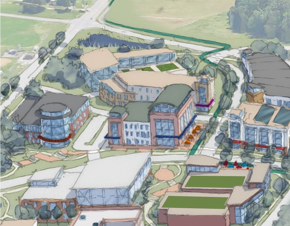
The scientific research facility in Durham will be located in a new development called The Edge near the town’s border with Lee. It will be called the Center of Excellence for Operational Ocean and Great Lakes Mapping.
What to expect from new center and The Edge
UNH and NOAA released joint statements on the facility and the The Edge project through NOAA spokesperson Kate Silverstein.
“The Center for Excellence will be the focal point of a new innovation hub located on a 60-acre parcel on the west edge of UNH’s Durham campus, on Mast Road and Main Street near the town of Lee,” the two parties noted. “It will be part of a larger mixed-use complex, called The Edge, that will house research labs, offices, retail spaces, dining and residential units and other amenities.”
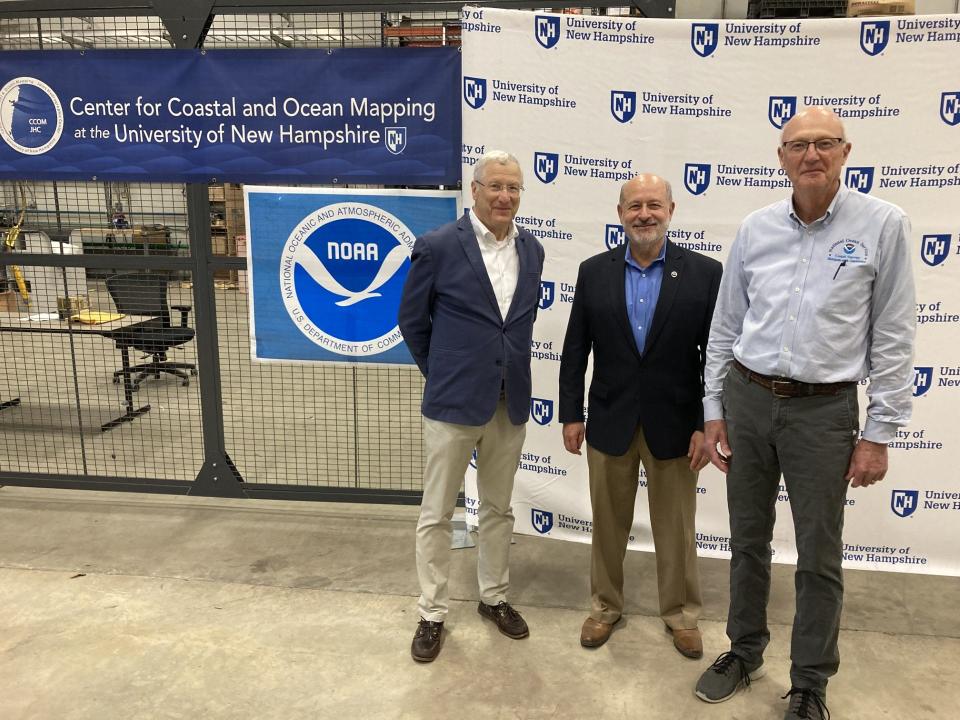
UNH has a 24-year ocean and Great Lakes mapping partnership with NOAA through its existing Center for Coastal and Ocean Mapping and Joint Hydrographic Center. The $20 million allocation from NOAA will last over three fiscal years, and the center will be part of NOAA's budget.
The Edge at UNH could employ 1,000, provide hundreds of housing units
Marian McCord, UNH’s senior vice provost for research, economic engagement and outreach, said the university has begun the visioning process for The Edge, adding the new mapping center will be the “cornerstone” of the mixed-use site.
The mixed-use complex is expected to have hundreds of housing units for graduate students, “industry partners” and other professionals working at The Edge, which could bring upwards of 1,000 new employees, she added.
“It’s in our best interest to have students, faculty, our other research scientists, our industry partners and our government partners in a space where they can rub elbows. That’s where innovation happens,” McCord said of the center.
“We expect to hire a combination of NOAA employees and contract associates,” Andy Armstrong, the co-director of the school’s Joint Hydrographic Center, said of the new center. “We don’t have the exact number at this point but we also expect that there’s going to be a number of industrial partners that join with us in adding jobs to the facility and to this hub."
The new mapping facility is planned to include office and instructional space, in addition to a high bay for storing, outfitting, and staging bulky equipment and small vessels, per the university and NOAA.
Hundreds of companies, McCord said, have communicated with the university their interest in being located on campus with the requests totaling about 1 million square feet of space.
“We don’t have the space right now,” she said. “That’s why we’re looking to develop out at the west edge, to be abe to accommodate all the requests that we’re getting.”
Work on the new mapping center will “hopefully start in the next year,” McCord said, though school leaders have not identified a date for a project groundbreaking as they get ready for the design process to begin.
The campus site where The Edge will be located currently houses university administrative offices and bus parking. The school is presently working with a real estate group to review the plan and identify potential financing avenues, according to Durham Town Administrator Todd Selig.
"UNH hopes to transform the location into a community where students, faculty, and UNH’s industry and government partners, can co-mingle and share ideas," Selig said.
More local news: Newmarket man’s death after ‘incident’ at Patriots game under investigation
NOAA leader explains ocean mapping work's importance
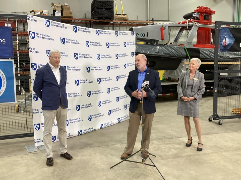
UNH officials welcomed Rick Spinrad, NOAA’s administrator, to the John Olson Advanced Manufacturing Center in Durham on Tuesday to announce the new center, which the parties will soon begin designing.
“We have requirements for mapping that are currently unmet. We have not mapped the U.S. coastline to the degree that’s required by a significant proportion,” Spinrad said.
Spinrad, who is also the nation’s under secretary of commerce for oceans and atmosphere, told attendees at Tuesday's event only about 50% of the country’s waters have been mapped, and some of the maps are decades-old.
He stated that mapping can help researchers understand how coastal structures are evolving, how flooding occurs, what the navigation hazards within shipping ports are, and how climate is changing.
“Consequently, the need to update those maps to do data acquisition is critical,” Spinrad said.
The university and NOAA defined ocean and lake mapping and explained its modern significance.
“In this context, ocean mapping is the scientific and engineering discipline of measuring the depth of and characterizing the water column and seafloor in order to support safe navigation, locate wrecks and other culturally significant features, model the effects of storms and tide, delineate critical marine habitat, and provide for the environmentally sound management of offshore resources,” the parties said in a statement. “NOAA and partners use the latest technology, such as multibeam echo sounders and side scan sonars, to complete a full 3-dimensional map of the seabed, much like the combination of a topographic map and an aerial photograph on land.”
NOAA leader sees big economic impact
Spinrad touted the new UNH center as a breeding ground for the next generation of underwater mappers and experts within their field.
As of 2019, according to Spinrad, marine economic activity was responsible for 2.4 million jobs in America and contributed $400 billion to the nation’s economy through transportation, shipping, tourism, recreation, fishing, power generation and coastal research.
“Comprehensive maps, charts and bathymetric data for America’s, coastal, Great Lakes and ocean waters is what keeps the “new blue economy” coming and allows for more efficient maritime commerce and transportation,” he said. “(It also supports) exciting development of clean energy resources and gathering critical data about how our oceans and coasts respond to climate change and extreme weather.
More local news: Willand Drive warming shelter funds being appoved. But who will run it?
Impact of program for UNH students
According to Larry Mayer, director of the school’s Center for Coastal & Ocean Mapping and the co-director of the Joint Hydrographic Center, the existing facility in Durham began about 20 years ago with a team of about a dozen employees. Their dream at the time was to grow into a world leader in developing mapping technologies and training younger ocean mappers, as well as to support NOAA’s mission.
Since its founding, the facility has graduated over 230 students, many of whom have gone on to careers in government agencies, the private sector and academia. This summer, the school collaborated with Exail to open a maritime autonomy innovation hub at the Olson Advanced Manufacturing Center.
“This momentum and our long history and close collaboration with NOAA has not gone unnoticed, and it’s brought us to today’s event,” Mayer said.
Durham leader praises project
Todd Selig, Durham's town administrator, lauded the project and assured the town’s support for the center. He touted the university’s leadership on oceanic and underwater mapping capabilities for 20-plus years.
“Like the UNH Olson Center for Advanced Manufacturing located just off campus on Technology Drive, the new NOAA center at UNH will not only advance core underwater research, but also link undergraduate and graduate students, researchers, private industry, and NOAA creating synergies and opportunities for the campus, the state, industry, and the nation,” he said. “Selecting UNH as the site was a smart move by NOAA; the agency has come to the right place to realize a meaningful return on investment.”
This article originally appeared on Fosters Daily Democrat: UNH, NOAA plan ocean mapping center at Durham mixed use development

