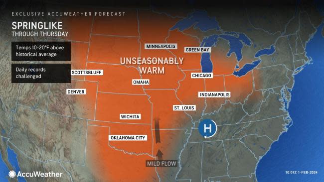
Unusual midwinter warmth to challenge records in north-central US


 |
Winter over the northern Plains and the Upper Midwest seems to be skating on thin ice as temperatures surge in the short term with no Arctic air or snowstorms in the near future, AccuWeather meteorologists say.
Unseasonable warmth will build over the region into Thursday and may stick around well into February with a few glitches along the way.
Mild air originating from the Pacific will dominate the weather pattern across the United States into the start of February, and, in tandem with the lack of snow across most of the country, will allow temperatures to soar.
 |
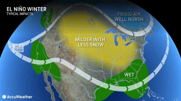
An El Niño pattern often ushers in an active storm track and resultant wetter conditions than the historical average across southern parts of the U.S. |
Clouds versus sun will hold the key for temperatures at midweek. Where the low clouds hang on, temperatures will be held back by 10-20 degrees. However, where the clouds break, the sunshine will allow temperatures to rise to springlike levels, especially where the ground is snow-free.
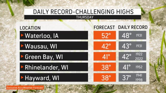
"Clouds have brought a gloomy sky during much of January, but the sun returned in style on Monday with high temperature records shattered in places like Minneapolis," AccuWeather Senior Meteorologist Matt Benz said. Temperatures hit 50 on Monday, blasting away the old record of 49 set during the Great Depression Era in 1931.
 |
After a brief push of cool air in the wake of a clipper storm Tuesday, temperatures will resurge over the region from into Thursday.
On Wednesday, Duluth, Minnesota, recorded a high temperature of 47 degrees, just one degree short of the Jan. 31 daily record of 48 degrees set way back in 1891.
 |
"High temperatures will be in the 50s across much of Minnesota at midweek and not only may set more daily record highs but also could challenge all-time records for January," Benz said. The highest temperature ever recorded during January at Minneapolis was 58 set on Jan. 25, during World War II in 1944.
As of the early afternoon, the temperature had already surpassed the Jan. 31 daily record of 46 set most recently in 2009 at Minneapolis.
Even where temperature records remain intact, temperatures will run 15-25 degrees above the historical average as January ends and February begins.
While temperatures well above the historical average may be great news for heating budgets it is bad news for private contractors that rely on plowing operations for income in the winter, and especially for outdoor winter activities such as ice fishing.
"During the heart of winter, ice anglers across the Upper Midwest are typically out on area lakes in full force," AccuWeather Long-Range Meteorologist and Angler Brandon Buckingham said. "This winter has been anything but ordinary with a late start to the season and now a potential record-breaking early ending to the season as well."
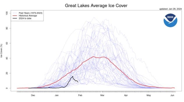
Some anglers in Wisconsin and Minnesota are making the difficult decision to remove seasonal fishing shanties due to the persistent and long-lasting warmth resulting in dangerously thin ice. Shanties can typically sit on thick ice that covers area lakes from late December into March, but ice cover on the Great Lakes is running well below the historical average this winter.
 |
"After a brief barrage of lake-effect snow earlier in January across Michigan, outdoor enthusiasts were optimistic for favorable conditions through the rest of winter, but that has since faded away as the warmth has settled in, causing the snow to melt away," Buckingham said.
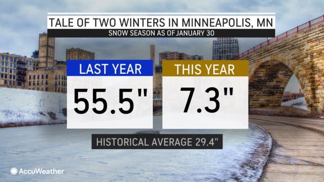
In many cases, the amount of snow so far this winter pales when compared to last winter.
 |
Snowmobilers have had a difficult time this season as well across the Upper Midwest. The world's largest snowmobile race, the International 500, is set to take place on Saturday, Feb. 3, at Sault Ste. Marie, Michigan. However, a lack of snow and dwindling snow cover could put that in jeopardy.
 |
The northern Michigan city typically averages around 10 feet of snow during winter, but so far this winter, less than half of that has fallen. The stretch of days between Jan. 22-29 has also featured temperatures of 11-21 degrees above the historical average. Only about 4 inches of snow remained on the ground as of Tuesday, Jan. 30.
"Heading into February, the magnitude of warmth will continue throughout the Great Lakes region with no additional snow foreseen in the near term," Buckingham said.
 |
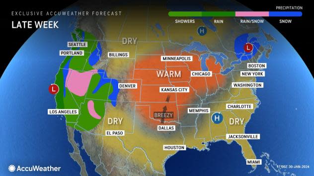
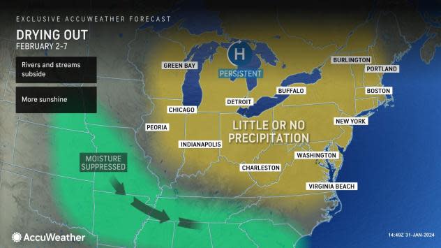
The main storm track will reside across the Southern states with only weak, moisture-starved systems across the northern tier.
"The evolving weather pattern is likely to feature an extended period where there is little to no precipitation -- perhaps 10 days or more from the Upper Midwest to parts of the Northeast," AccuWeather Senior Meteorologist Brett Anderson said.
 |
The lack of moisture and major storms could be great news for those yearning for sunshine after a very cloudy month. The increase in sunny days may help relieve those suffering from seasonal affective disorder.
The Southern storm track includes rounds of rain and mountain snow for California in the coming days, with one storm of several to hit through Friday.
Want next-level safety, ad-free? Unlock advanced, hyperlocal severe weather alerts when you subscribe to Premium+ on the AccuWeather app. AccuWeather Alerts™ are prompted by our expert meteorologists who monitor and analyze dangerous weather risks 24/7 to keep you and your family safer.
