Pre-Valentine's Day snowstorm brewing as weather pattern flips in northeastern US


AccuWeather meteorologists are closely monitoring a storm that is likely to bring a strip of accumulating snow from parts of the Midwest to the Northeast early next week.
Where and how much snow falls will depend on the storm's strength which may fluctuate, and the storm's track, which may shift north and south over the next several days.
 |
In the short term, temperatures will be on the upswing in the wake of an Atlantic storm that buried Nova Scotia under feet of snow earlier this week. A flow of dry air west of that storm has already delivered days of bright sunshine and cold nights to much of the central and eastern United States.
 |
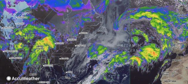
This wide-view image, taken on Wednesday, Feb. 7, 2024, shows a massive storm over the North Atlantic (right) and the storm that hit California with a major atmospheric river breaking up over the western United States (left). A wedge of mainly cloudless skies can be seen in the eastern U.S. (left of center). (AccuWeather Enhanced RealVue™ Satellite) |
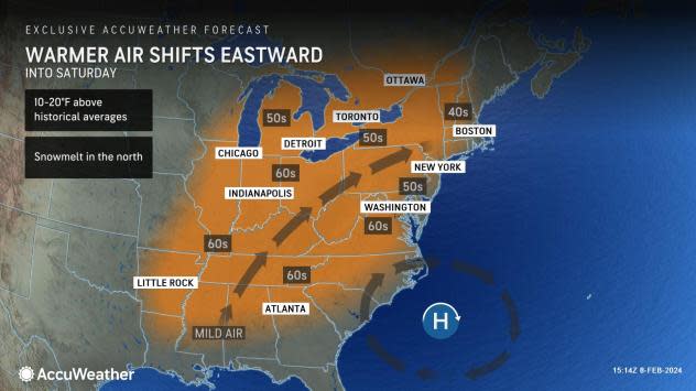
As that Atlantic storm moves away, a southwesterly flow of air will expand from the Central states to the East into Friday.
Into the weekend, highs will range from the 40s F over the northern tier of New England to widespread 50s around the Great Lakes, central Appalachians and upper mid-Atlantic to the 60s over much of the Ohio Valley and Southern states.
 |
However, the clock will be ticking on the warmer weather pattern as soon as it begins.
"While the January thaw and break from the stormy pattern extended into early February, there is going to be a change in the pattern with a potentially impactful storm coming swinging across the Midwest and Northeastern states from Monday to Tuesday," AccuWeather Meteorologist Dean DeVore said.
 |
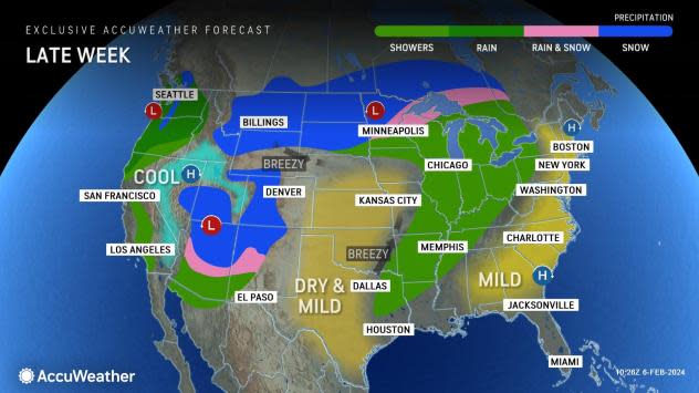
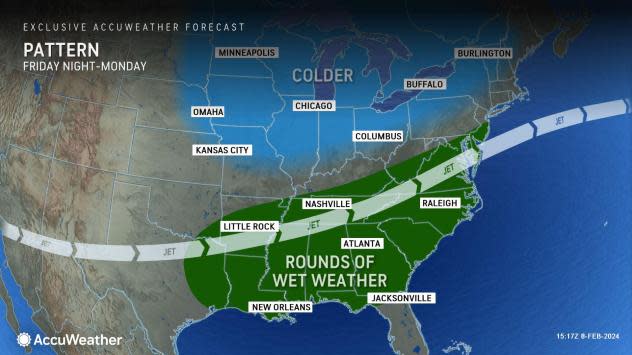
First, the South Central and Southeast states will experience a return of cloudy and rainy conditions centered on this weekend.
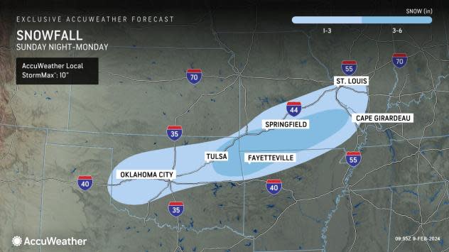
The storm potential DeVore alluded to includes a strip of accumulating snow that may first appear over parts of the southern High Plains on Sunday and extend across portions of the middle Mississippi Valley to the Ohio Valley from Sunday night to Monday. However, the amount of snow that falls in this area could be limited as the air may not be quite cold enough, resulting in more raindrops than snowflakes.
The best chance of several inches of snow and slippery travel will be centered near the Ozark Mountains in southern Missouri.
 |
"Colder air will gradually be drawn into this storm as it moves from the Central states to the Eastern Seaboard," AccuWeather Chief On-Air Meteorologist Bernie Rayno said. "How quickly that occurs will depend on how fast the storm strengthens."
If the storm remains weak, it will likely race eastward with only small snow accumulations from the Ohio Valley to the central and southern Appalachians and perhaps a wintry mix in the mid-Atlantic late Monday into Tuesday.
 |
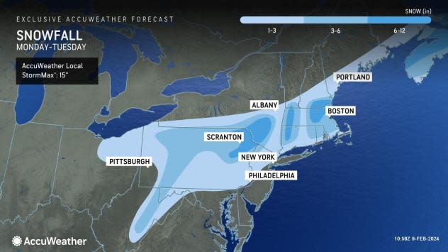
Should the storm organize and strengthen, it would track farther north to produce a broadening swath of accumulating snow from the central Appalachians to New England, with drenching rain and thunderstorms to the south.
Both scenarios and others that include a major nor'easter and only spotty precipitation are still in play. Most of these would still allow some snow to fall from the Ohio Valley to parts of the Appalachians.
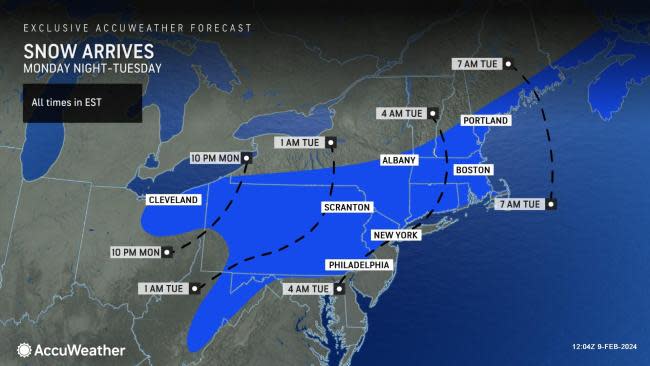
AccuWeather has issued a forecast snow accumulation map for the Northeast that represents the input from dozens of its meteorologists with a combined experience of hundreds of years.
 |
Should the storm develop to its full potential, a heavy snowfall may occur in parts of the Northeast and some people may spend the first part of Valentine's Day digging out or dealing with possible travel delays in the wake of the storm.
"One thing is for sure, this storm will start a pattern that brings colder, more active weather from the Midwest to the Northeast with reinforcing shots of seasonably cold air masses with the potential for some clipper systems to bring snow events," DeVore said.
Want next-level safety, ad-free? Unlock advanced, hyperlocal severe weather alerts when you subscribe to Premium+ on the AccuWeather app. AccuWeather Alerts™ are prompted by our expert meteorologists who monitor and analyze dangerous weather risks 24/7 to keep you and your family safer.
