Vigorous storm threatens California with tornadoes, flash floods
A powerful storm rolling into the U.S. West Coast will produce widespread dangerous weather across California to start the week.
Forecasters throughout the state warn that an atmospheric river could fuel a risk for flash flooding and prolific mountain snows.
Dynamics are even favourable for supercell thunderstorms that could produce a few tornadoes across parts of the Central Valley around Sacramento.
DON'T MISS: An expert explores the good and the bad of atmospheric rivers
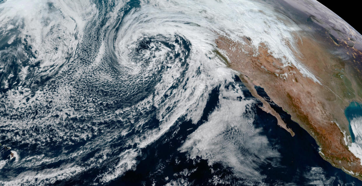
A low-pressure system moving across the eastern Pacific Ocean began pushing into the California coast on Sunday. Heavy precipitation and gusty winds are likely through the day Monday before conditions gradually improve from north to south into Tuesday.
This is a large storm that’ll bring a wide range of hazards to most of the Golden State. Such a wide reach is no small feat given that California stretches more than 1,200 km from San Diego north to the Oregon border.
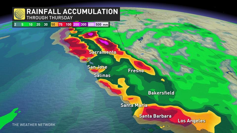
200+ mm of rain renews flash flood concerns
A formidable atmospheric river will provide ample fuel for heavy rainfall across the region. The greatest risk or flash flooding exists along and near the coast, including the San Francisco Bay area and the Los Angeles metro area.
Rainfall totals of 25-50 mm are possible across both San Francisco and Los Angeles by Tuesday. Isolated rainfall totals of 200+ mm are possible in higher elevations north of Los Angeles toward Santa Barbara.
MUST SEE: Atmospheric rivers becoming so intense we need to rank them like hurricanes
The risk for triple-digit rainfall totals across higher terrain led the U.S. Weather Prediction Center to issue a moderate risk for flash flooding along portions of the coast.
This enhanced flood potential includes the cities of San Luis Obispo and Santa Barbara. Mountainous terrain leaves this region especially vulnerable to flash flooding and landslides.
Blustery winds are likely across California for the duration of the storm. Many areas may see wind gusts of 80-100+ km/h through Monday, with even higher gusts at higher elevation. The combination of wet soil and high winds could lead to tree damage and power outages.
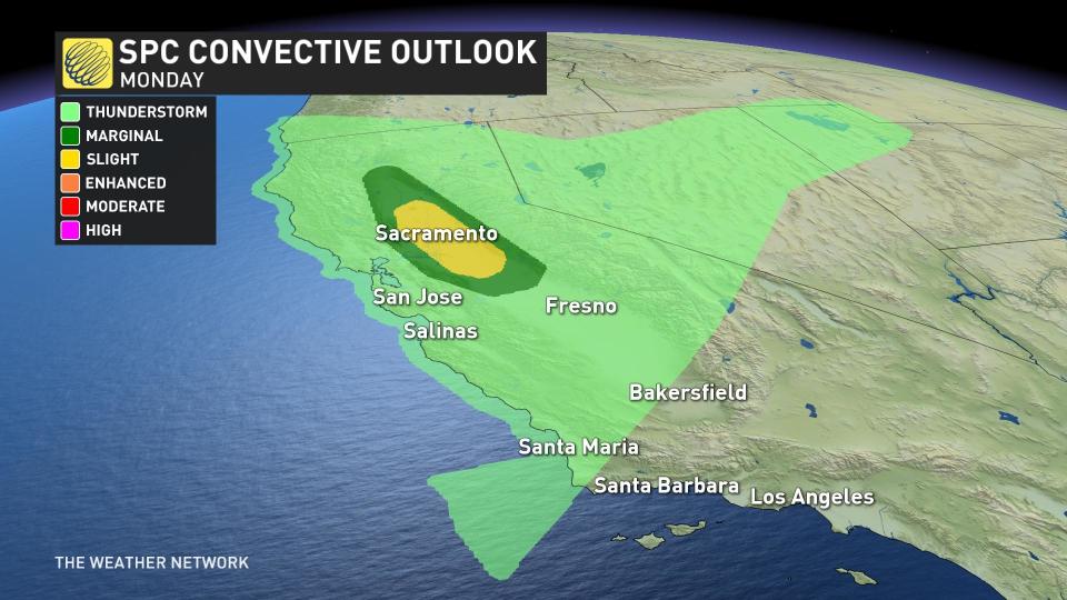
Tornado risk for the state capital on Monday
Cold temperatures aloft will provide enough instability to give rise to isolated thunderstorms across California’s Central Valley on Monday.
Forecasters with the U.S. Storm Prediction Center (SPC) highlighted a risk for severe weather around Sacramento—the state capital—as well as the cities of Stockton and Modesto.
RELATED: Tornadoes can happen anywhere—and cities aren't immune
Any thunderstorms that form in the Sacramento Valley could organize into supercells that carry a risk for damaging winds and even isolated tornadoes.
Tornadoes aren’t terribly uncommon in California. The SPC documented 466 tornadoes in California between 1950 and 2022, an average of about 5 or 6 tornadoes each year.
Most of the state’s tornadoes rank as EF-0 or EF-1 on the Enhanced Fujita Scale, forming during the late winter and early spring within storms very much like the one hitting the state this week.
Heavy mountain snows are likely
One area that’s sure to welcome the surge of moisture is the Sierra Mountains.
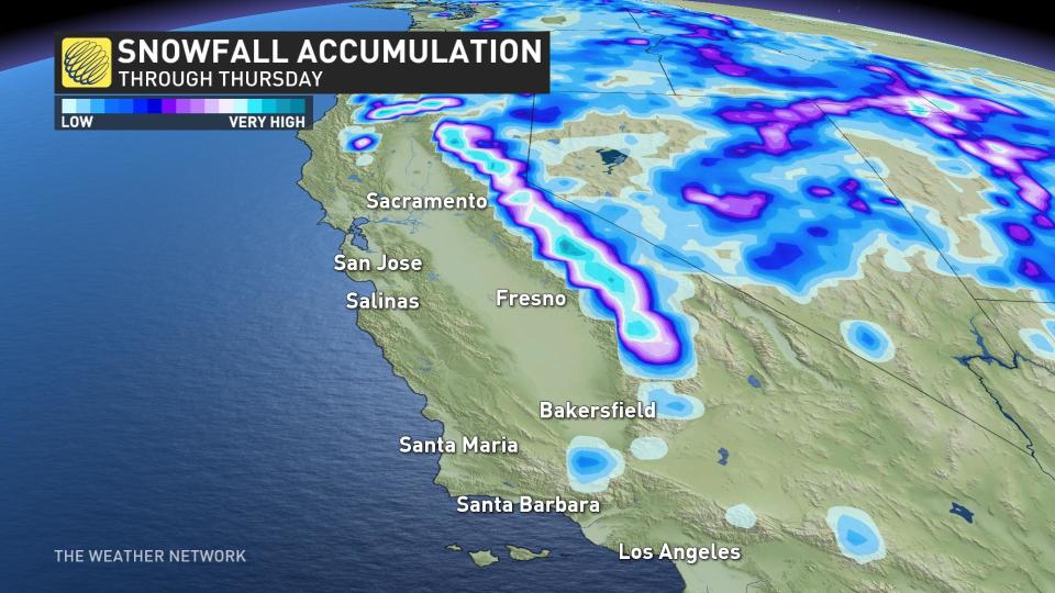
Forecasters expect 100-200+ cm of snow across the mountains, with freezing levels falling to around 1800 m by Monday. This will make travel difficult or nearly impossible at times through the mountain passes.
A deep snowpack isn’t just good for the region’s ski resorts. Mountain snowmelt is a significant source of freshwater for much of California come the spring and summer.
Despite the recent storms, this weekend’s average snow depth across the Sierra came in around 70 to 80 percent of normal for the middle of February.
Strong California storms common in El Niño winters
California is no stranger to disruptive storms during El Niño winters. The same patterns that affect Canadian weather also force a strong jet stream to drape over the southern half of the United States, allowing repeated storms to hit the West Coast.
Los Angeles came close to seeing its wettest day on record amid a powerful atmospheric river at the beginning of the month.
The University of California’s downtown campus measured more than 100 mm of rain on February 4, tying the record for tenth-wettest day ever recorded in the city. The storm killed several people across the state and knocked out power to hundreds of thousands of homes.
Header image courtesy of NOAA.

