Walking RI: Discover a hidden gem of forest, ponds and wetlands in Little Compton
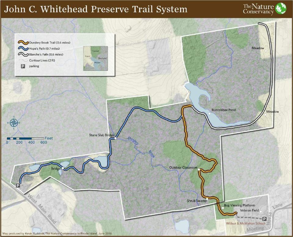
LITTLE COMPTON — Three different paths lead to Dundery Brook and the surrounding forested lowlands in the John C. Whitehead Preserve.
One follows a dirt and grass trail over plank bridges and around several tiny ponds. Another crosses a three-quarters of a mile raised boardwalk under oak, beech, holly and red maple trees. And the third winds along an old farm lane and by meadows lined with wildflowers on what was once Bumble Bee Farm.
I decided to hike all three to get the full experience of the 188-acre preserve named for Whitehead, the late naval officer, investment banker and diplomat who founded the Rhode Island chapter of The Nature Conservancy. A nonprofit organization, the conservancy acquired the property from the heirs of former landowners and established the sanctuary in 2001.
Walking RI: Spectacular bay views and Colonial and tribal history at Mount Hope Farm
Walking RI: Discover why hikers and anglers love the 'wild and scenic' Beaver River
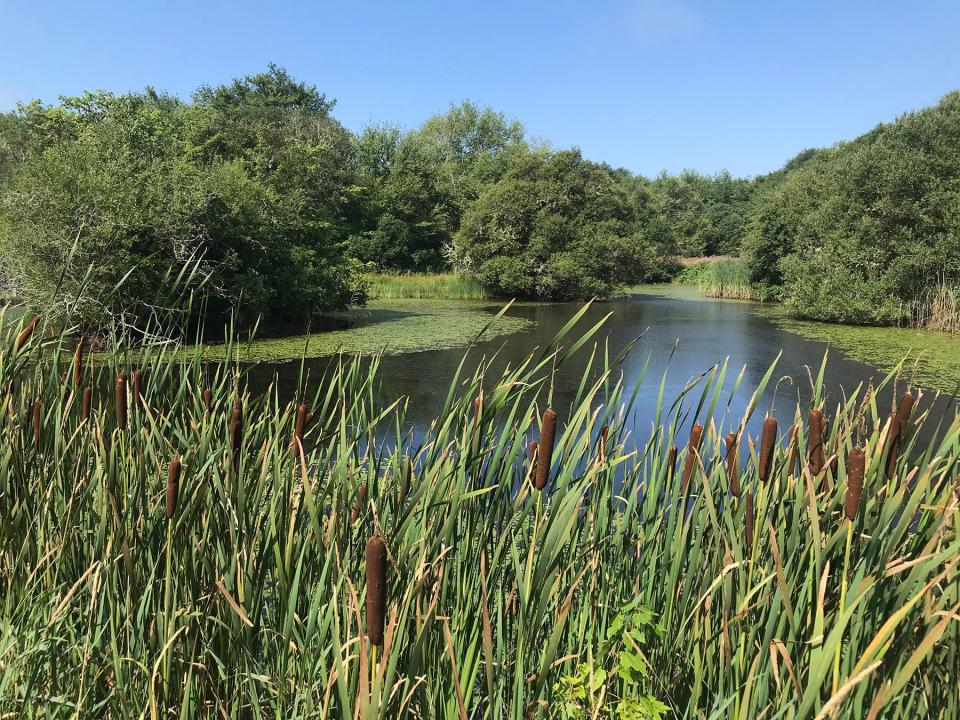
Hope's Path: A trio of ponds surrounded by woods and meadows
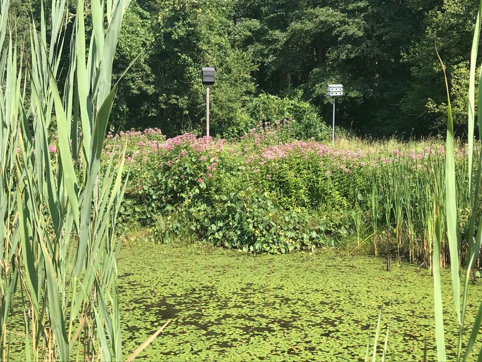
Setting out from the trailhead on West Main Street, I headed east on Hope’s Path, named for Hope Burchard Purmont, who used to own the property. The grassy trail ran along the banks of the small, man-made ponds that were covered with lily pads, cat-o'-nine tails and tall reeds. I noted a bat box and a birdhouse on poles above the edge of the water.
Purmont’s father, Leeds Burchard, dug the first pond by excavating to the groundwater level and letting the depression fill, a once-common practice to create watering holes for livestock. In the late 1960s, her sons, George and Wayland, dug the other ponds and stocked them with fish.
Hope’s son George Purmont and his wife, Daune Peckham, a landscape architect, planted native wildflowers and shrubs around the ponds, which attract birds and pollinators in spring and summer.
Walking RI: Want to practice some rock climbing? Head to Connors Farm in Smithfield
Walking RI: Leave the noise behind at a wooded retreat in Richmond
As I walked, the path passed through gaps in several stone walls and crossed a series of bog bridges laid down over wetlands and unnamed seasonal brooks that had dried out in early August during the severe summer drought.
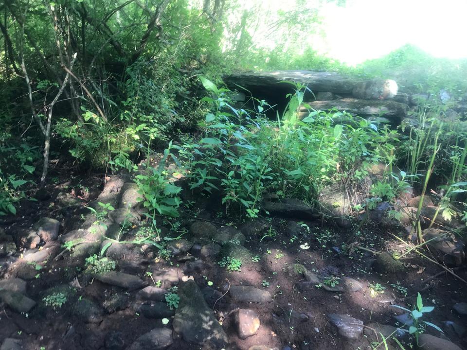
A short distance later, I crossed Dundery Brook on a bridge made of four, huge stone slabs supported by smaller, rounded stones and built strong enough to carry farm wagons.

The brook usually flows southeast across the preserve and supplies clean freshwater to the coastal lagoon ecosystem downstream at Briggs Marsh. But the brook had dried up during the recent heat wave, and the bed was dark, cracked mud.
Walking RI: Follow in the footsteps of Trappist monks in Cumberland
Walking RI: Tillinghast Pond's trails are part of something special and well worth a visit
The floodplain that surrounds the brook includes swamps, marshes, mixed forests and wet meadows. While the drought had parched nearby farms and hillsides, the streamside areas, known as riparian zones, had stayed green. On hot summer days, the stream beds often dry out, but within the floodplain, there is still much water below the surface, slowly percolating to recharge groundwater reservoirs. After thunderstorms, surges of freshwater run down the channels to revive pools along the way and refresh Briggs Marsh, which remained as high as ever in August.
Dundery Brook Trail: A boardwalk 'classroom' to study wetlands
Continuing down the trail, I walked on narrow dirt and rooted paths, lined with thick ferns, and crossed more board bridges, some newly constructed by volunteers, before coming to a T-intersection, with a raised boardwalk that ran left and right. I went right and south and followed the 4-foot-wide boardwalk, which has low rails on both sides and is elevated about 4 feet off the ground. In several places, there are bump-outs where you can pause and study the trees, native shrubs and wetlands. In other places, the walkway has high railings and wire mesh sides.
Walking RI: Mingle with birds, beavers, mink and more at Exeter's Fisherville Brook refuge
Walking RI: Ninigret National Wildlife Refuge harbors naval, tribal history
The boardwalk, built in 2012 from durable, native black locust, zigzags through the preserve and offers a flat, easy walk for walkers of all ages and is wheelchair accessible.
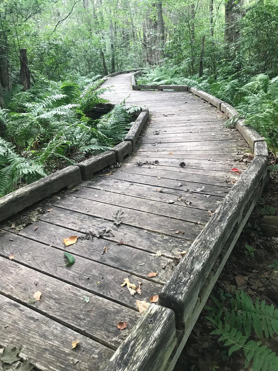
It also serves as an outdoor classroom where young people can study the ecology of the wetlands, vernal pools and flowering plants, including jack-in-the-pulpits. During the wet spring months, water is underneath the boardwalk for its entire length.
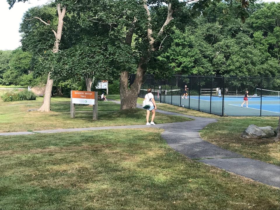
I followed the boardwalk until I heard the “thump” of a tennis ball hitting the strings of a racket and walked through an opening in the brush to find a sports complex with tennis courts, a paved walking track and a soccer field being watered by sprinklers. The Wilbur & McMahon School is nearby.
I met a walker who told me the tents set up on the property were for a community chicken barbeque which was set up off the parking lot on Meetinghouse Lane. The lot also serves as a trailhead for the preserve.
Walking RI: Looking for a great birdwatching spot? Try this former Navy site in North Kingstown
Walking RI: A step-by-step guide to beautiful Stepstone Falls
She said she walks through the Whitehead Preserve regularly and couldn't recall an August when it had been this dry. But she added that the drought hasn’t curbed the mosquitoes, ticks and deer flies. I rested on a bench and reapplied some insect repellent.
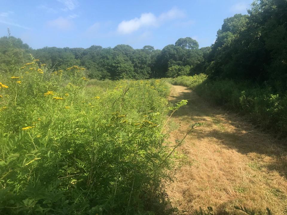
Blanche's Path: Flower-filled trail through former Bumble Bee Farm
After watching a tennis match for a few minutes and drinking some water, I returned to the boardwalk and retraced my steps all the way to the junction I had passed earlier. This time, I went right on the boardwalk for a few more yards before it ended at a wide, grassy path called Blanche’s Path, named for Blanche Borden Frenning. She and her husband, Alfred, acquired and expanded the property starting in the 1930s. They named the farm Bumble Bee.
Blanche, nicknamed “Inchy,” loved horses and was an interior designer and architect with expertise in Colonial homes. She took care of much of the farm herself.
Walking RI: Best place for a hike and osprey spotting? Try the Great Swamp in South Kingstown
Walking RI: Trestle Trail in Coventry is a great spot for fitness training
The path runs along Bumble Bee Pond, a simple impoundment built in the 1940s to capture surface runoff and water the horses. Blanche reportedly enlisted help building the dam from soldiers stationed at nearby Fort Church. Locals say her real intent was to tire the men out so as to give the young women in town some rest from their pursuit.
Along the banks of Bumble Bee Pond, the reeds and bushes had grown so high that it was difficult to see the water. But as I walked the path, I heard the splash of turtles and frogs slipping into the pond. At one point, I rousted a heron that took flight.
Hikers report sightings of deer and wild turkeys in the fields alongside the path, and birders have identified 60 species, including warblers, vireos, hawks, owls and Baltimore orioles. The pond is also a stop for migratory ducks.
Walking RI: Retracing Thoreau's 1854 hike through Providence
Walking RI: Rediscover Providence's Roger Williams Park on a serene hike around its ponds
Walking RI: Time-traveling along the Queen River in Exeter
I followed the path over a wooden bridge and passed meadows filled with wildflowers, bees and butterflies before the trail came to an end, marked with a chain and a private property sign. I turned around and walked back to the boardwalk and then followed Hope’s Path back over Dundery Brook to where I'd started.
In all, I walked about four miles over two hours.
The Nature Conservancy plans to add another mile of trails to create a loop through the preserve. That will give me a good excuse to return, maybe in the spring, when water should be flowing through the brooks and the wetlands will be alive with new life.
Now that I think of it, the preserve wouldn’t be a bad walk in the fall, either, when the leaves turn color. The trees and bushes along the boardwalk must be a spectacular sight.
John Kostrzewa, a former assistant managing editor/business at The Providence Journal, welcomes email at johnekostrzewa@gmail.com.
This article originally appeared on The Providence Journal: Walking RI: A lovely woodland hideaway in Little Compton

