Walking RI: Discover why hikers and anglers love the 'wild and scenic' Beaver River
RICHMOND — The Beaver River rises from James Pond in Exeter and flows south for 11 miles through the heart of Richmond before eventually emptying into the Pawcatuck River.
While the Beaver River may not be as well-known as other major waterways in Rhode Island, its large watershed and floodplain provide a rich habitat for wildlife, vegetation and fish. Anglers have been catching wild brook trout in the cold, clear river for generations. The groundwater in the watershed is a source of drinking water for thousands and helps farmers along a southern stretch irrigate their fields.
And besides all that, the river is simply a lovely place for a walk.
Walking RI: 5 great hikes with ocean views
Walking RI: Want to practice some rock climbing? Head to Connors Farm in Smithfield: Walking RI
Walking RI: Leave the noise behind at a wooded retreat in Richmond
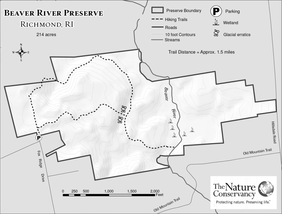
I explored the river during back-to-back hikes in the Beaver River Preserve, managed by The Nature Conservancy (TNC), and a smaller area to the south, called Beaver River Park, owned by the Town of Richmond.
Setting out from the trailhead at the end of Fox Ridge Drive, I started my hike by walking down a small embankment. At a junction, I went left on a yellow-blazed trail that passed through a boulder-strewn forest.
Walking RI: Follow in the footsteps of Trappist monks in Cumberland
Walking RI: Tillinghast Pond's trails are part of something special and well worth a visit
Amy's Rhode: Amy Russo tests the waters with a kayak trip on RI's 'wild and scenic' Wood River
The path weaves through oak trees and soon crosses wooden-plank walkways over seasonal brooks and seeps, wet areas where groundwater comes to the surface and pools. Some of the narrow boards were slippery after an overnight rain.
The footpath then bends east and downhill and was, at times, overgrown with bright-green ferns, bushes and tall, thick, wild grass in clearings. A few downed trees also crossed the path.
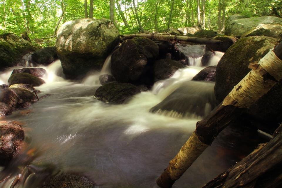
At one point, the trail softened, with needles dropped from a stand of pine trees along a ridgeline covered by boulders of all shapes and sizes that ran parallel on the right.
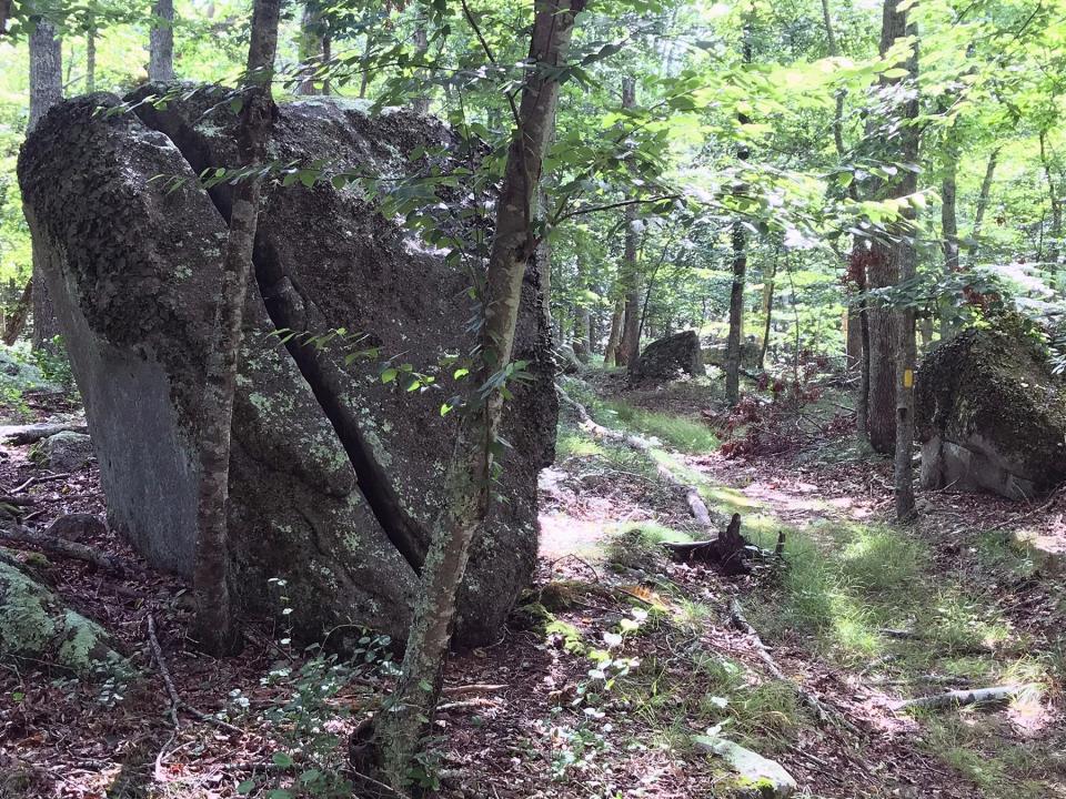
At a junction, one trail on the right went uphill while the other, on the left, went downhill. I headed southeast on the downslope toward the river on a wide cart path, lined with giant boulders. Some were split and cracked. Others were covered with lichen and thick, green moss.
Walking RI: Trolley line left its mark at Lincoln's Lime Rock Preserve
Walking RI: Mingle with birds, beavers, mink and more at Exeter's Fisherville Brook refuge
The path led to a short wooden bridge over what looked like a tributary from the river. But it may actually have been a manmade channel, because when I followed it along its banks to the right, I found the remains of a stone foundation and what was perhaps a dam built to hold back water. I also noticed the land was raised on both sides to funnel the water to the mill. I learned later that a Colonial-era grist mill once operated on the site.
Walking RI: Ninigret National Wildlife Refuge harbors naval, tribal history
Walking RI: Looking for a great birdwatching spot? Try this former Navy site in North Kingstown
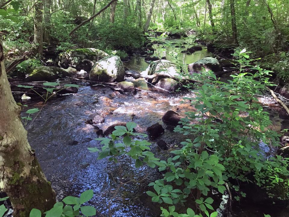
After returning to the bridge, I followed the main path for a short distance for my first look at the Beaver River. I stood there for a while and watched the 15-foot-wide river flowing slowly downstream around a bend and south.
Wonder why it's called Beaver River? The evidence is all around
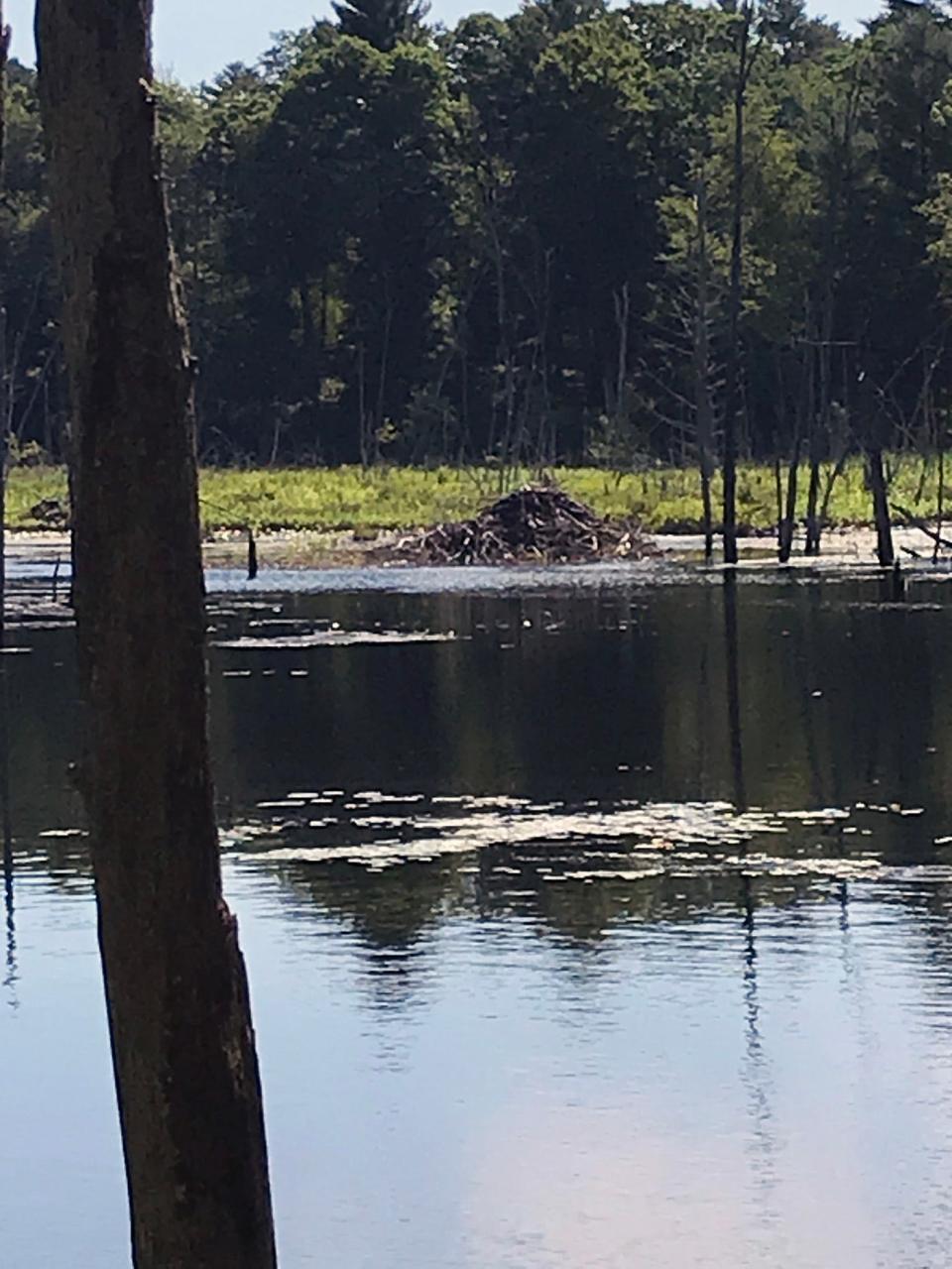
But what also caught my attention was an extensive network of beaver dams built of sticks and mud on the river and adjacent streams that have backed up the water to form a huge, shallow swamp to the north. I also spotted a large, rounded beaver lodge about 50 yards offshore and ducks swimming on the surface of the marsh.
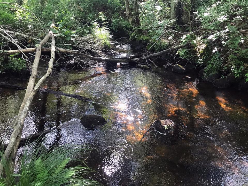
Looking across the river, the cart path seemed to continue into the brush, but a wooden footbridge that once let you cross the river is long gone. I decided against trying to cross the river on some downed branches that fell across the water, or taking off my boots to wade across.
Walking RI: A step-by-step guide to beautiful Stepstone Falls
Walking RI: Best place for a hike and osprey spotting? Try the Great Swamp in South Kingstown
On the east side of the river, The Nature Conservancy recently acquired 52 acres, including a white pine grove and a bog. The conservancy is exploring the possibility of creating a trailhead and parking on Hillsdale Road, with a trail that crosses the river from the east and connects to the existing paths.
Walking RI: Trestle Trail in Coventry is a great spot for fitness training
Walking RI: Retracing Thoreau's 1854 hike through Providence
After studying the river for a bit, I turned and retraced my steps on the cart path to the junction I had passed earlier. This time, I went left and up a gradual rise to a line of outcroppings and glacial erratics deposited during the Ice Age. The path wound through the boulders, but I ran into thick, thorny vines and had to find a side path around them before circling back to the main path and continuing up the hillside. Along the way, I crossed more seeps on boards laid down as part of a Boy Scout Eagle Project. I learned later that the Scouts also built the wooden bridge I'd crossed by the river.
After a short distance, I saw a house through the trees to the left and soon after returned to the trailhead.
I’d hiked about 2.5 miles over 90 minutes. But my trip wasn’t over.
Farther south, a 'catch and release' fishing spot
I wanted to see the river farther downstream, so I drove south to Route 138 and then east to the intersection with Beaver River Road. There’s a turnout and fishing area there managed by the Rhode Island Department of Environmental Management. The water flows under a concrete bridge and by 10 stone slab steps that lead to the water.
DEM stopped stocking the river with hatchery trout last year, but there are footprints and other evidence on the banks that anglers still wet a line here. The river is designated a no-kill “catch and release” area, meaning that any caught fish have to be returned to the river immediately.
Walking RI: Take in the fragile beauty of Warren's Touisset Marsh during a coastal hike
Walking RI: At Trustom Pond in South Kingstown, silence is golden
I also found a monitoring device maintained by the U.S. Geological Survey since 1974 to measure river flows. The data collected helps in the design of bridges, culverts and fishways and forecasts the potential for downstream flooding for villages such as Kenyon and Shannock.
Recent monitoring shows water levels are low because of the drought this summer.
Deciding to move on, I then drove a short distance down Beaver River Road to Beaver River Park on the left. At the edge of a playground, a 15-foot-wide, mowed, grassy path leads into the woods and around a large field covered with wildflowers and a few bluebird boxes. I saw forested swampland on the right and passed a line of cedar trees.
Walking RI: Coastal views and prime bird-watching at Tiverton's Emilie Ruecker preserve
Walking RI: A birder's paradise by the shore in Middletown
The path turned into a small clearing when it reached the river, with a sitting bench and several wooden steps down the bank. The river here is shallow and about 20 feet wide and flows easily south through a flat, wide floodplain for about 3 miles to the Pawcatuck River. Several oaks had fallen across the waterway, giving the area a wild, natural look.
I returned to the main trail and before heading back to my car, circled the field to complete a stroll of about three-quarters of a mile.
Beaver River is part of the National Wild and Scenic Rivers System
About 90% of the land along the Beaver River is undeveloped and half of the river runs through protected properties held by The Nature Conservancy, RI DEM, towns and local land trusts. The unbroken forest and 20-square-mile watershed along its banks provides a clean, cold-water habitat for fish, wildlife and birds.
Walking RI: Retracing an Aussie Walkabout in George Washington Management Area
Walking RI: Hollywood wow factor on Hopkinton trail
Those attributes qualified the Beaver River in 2019 to be a National Wild and Scenic River in 2019. The special designation was created in 1968 under a federal law enacted to preserve rivers with natural, cultural and recreational values.
That’s a great way to describe all that I found while walking along the river.
Trail Tip
Guidelines for the Beaver River Preserve:
• Stay on marked trails.
• Visit from one hour before sunrise to one hour after sunset.
• Do not ride horses, bikes or motorized vehicles.
• Do not remove or disturb vegetation.
• Remove all trash.
• Dress in long pants for protection from ticks.
John Kostrzewa, a former assistant managing editor/business at The Providence Journal, welcomes email at johnekostrzewa@gmail.com.
This article originally appeared on The Providence Journal: Fish and hike at Richmond, RI's beautiful Beaver River Preserve

