Walking RI: Family-friendly hiking at a former Girl Scout camp in Westerly
WESTERLY — Generations of Girl Scouts once gathered at Camp Wahaneeta to hike the hilly terrain, rock-hop across brooks, play sports in the meadow, swim in the pond and learn outdoor skills.
But the camp closed in 1996 and the Scouts sold the property in 2012 to the Westerly Land Trust. Since then, volunteers have built bridges over streams, blazed trails, cleared blowdowns, repaired old structures and created a 73.7-acre public preserve with color-coded paths that are perfect for family hikes.
If you’re more ambitious, though, and want to hike through deeper woods and along rockier trails, the Wahaneeta Preserve abuts the Woody Hill Management Area, which includes a wildlife marsh, an overgrown cemetery and stone foundations built by early farmers.
Walking RI: Looking for a great birdwatching spot? Try this former Navy site in North Kingstown
Walking RI: Immigrant war hero's legacy lives on at Glocester preserve
Overall, the connected preserves include 1,200 acres of public land that can provide a great outdoor experience for hikers of all ages and interests.
A hiking buddy and I recently decided to hike through both preserves. At the trailhead, we stopped at a kiosk to check a trail map and then set out to explore.
Walking RI: A step-by-step guide to beautiful Stepstone Falls
Walking RI: Best place for a hike and osprey spotting? Try the Great Swamp in South Kingstown
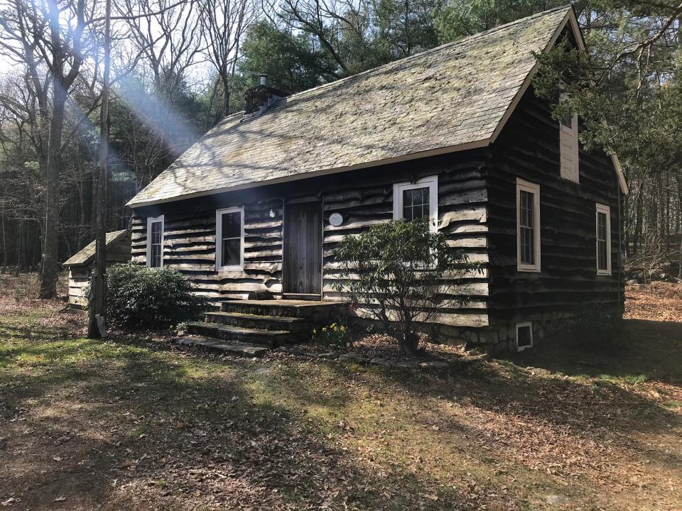
We walked a short distance on a dirt road to a lodge, built with a slate roof and timber harvested and milled at the nearby Crandall sawmill. There's a rustic flagpole out front where Scouts must have raised the colors to start the day at Wahaneeta, which opened for its first season in 1941.
An early Scout, Evelyn Reese, won a composition contest to name the camp by writing about the Native American maiden Wahaneeta, whose name means “faithful.” According to legend, Wahaneeta stood on a bluff in Watch Hill waiting for her lover to return from the sea. When he did not, she jumped to her death.
Just down the slope from the lodge is a covered pavilion, a meadow and other camp buildings.
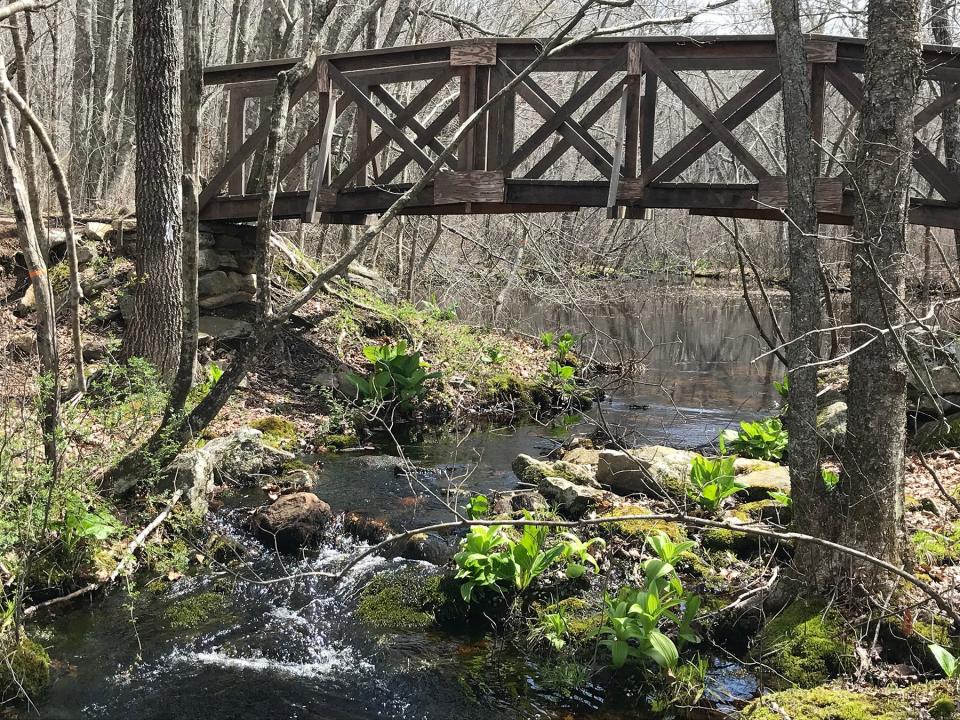
We took the blue-blazed perimeter trail east and noted small signs that identified white oak, red cedar and birch trees. The path follows a stone wall on the right, passes outcroppings and climbs a small rise before leveling off and descending to a hollow and a stream crossed by a wooden bridge. One of the planks has CCC 2022 carved in it, marking the work of the Coffee & Clearing Club of volunteers who keep up the property.
Walking RI: Exploring trail-blazer 'Vin' Gormley's playground in Charlestown
Walking RI: At Peck Pond in Burrillville, enjoy the calm before the summer rush
After the bridge, the trail soon passes an 82-foot-tall sweet black birch, with a circumference of 159 inches. The tree is recognized by the Rhode Island Tree Council as one of the biggest of its kind.
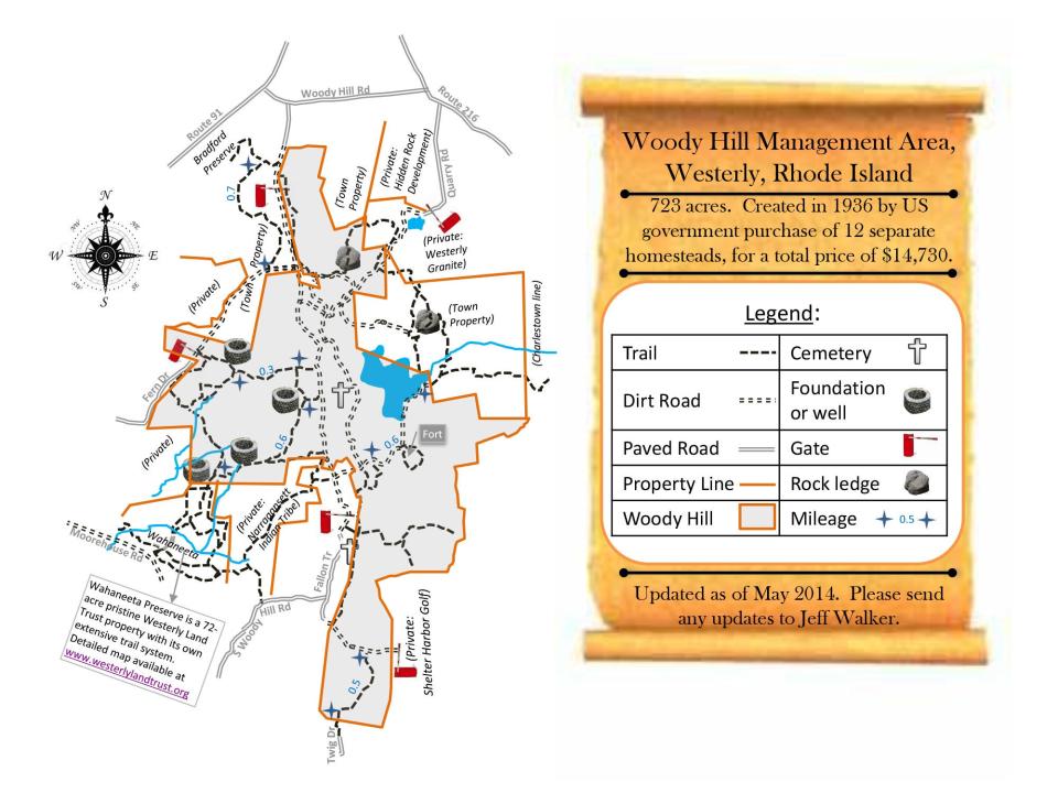
Woody Hill Management Area has a link to FDR's New Deal
At the northern tip of Wahaneeta, a trail leads north into the Woody Hill Management Area, named for a 200-foot hill in the preserve that is managed by the Rhode Island Department of Environmental Management.
The blue-dot-blazed trail then reaches a fork. We went right and passed a 15-foot square cellar hole for a house with stone steps leading down and a center chimney near the back wall. There was also a side room on the back that may have been for storage.
Just ahead there’s a three-sided stone foundation for a barn or storage building, a stone-lined well and a manmade channel to a stone-rimmed depression in the land that probably caught runoff to form a farm pond for watering the livestock.
Walking RI: Trestle Trail in Coventry is a great spot for fitness training
Walking RI: Seal-watching and scenic splendor at Rome Point in North Kingstown
The property was one of 12 homesteads the federal government purchased under the Bankhead-Jones Farm Tenant Act of 1937. The law, passed as part of Franklin Delano Roosevelt’s New Deal, allowed the acquisition of land no longer fit for agriculture.
The property, about 723 acres, was transferred from the U.S. Forest Service to Rhode Island in 1955 to form the Woody Hill Management Area.
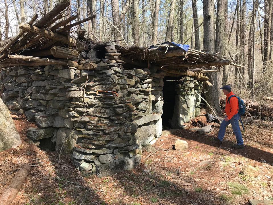
When the trail reached a road, we turned right and followed it by a small, stone-walled shelter. The locals call it the “fort,” and it was part of the farm owned by Charles Saunders (1819-1904) and later his son. Nearby, parallel stone walls may have been built to herd farm animals.
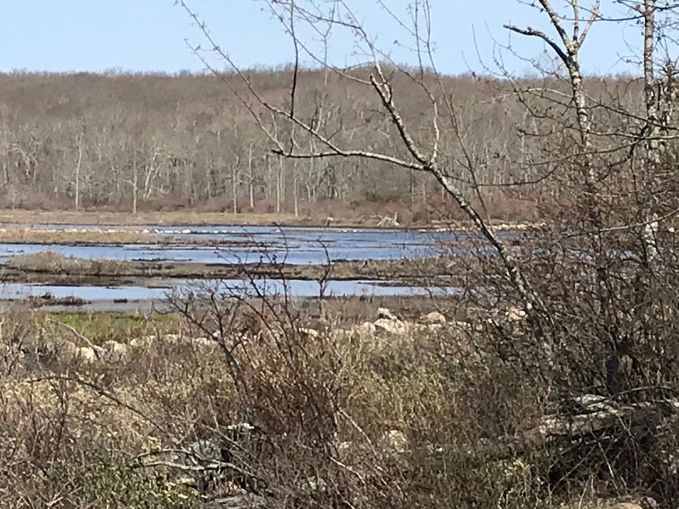
The road runs over a hill and then down a slope and across an impoundment that holds back water to create a wildlife preserve. The stream flows through the dam and forms Perry Healy Brook, which runs into the Burlingame State Management Area and under the Vin Gormley covered bridge.
Walking RI: Column's readers and fans share their RI trail wisdom
Walking RI: Retracing Thoreau's 1854 hike through Providence
In 2016, DEM and Ducks Unlimited, an organization that conserves, restores and manages wetlands and habitats for waterfowl, partnered to improve the impoundment and replace an old water control structure that had been clogged by beaver activity, mud and debris.
Managing water levels to benefit both native plants and ducks
The improvements allow the DEM’s Division of Fish and Wildlife to manage water levels and replicate natural cycles. In the spring and summer, the water is lowered to promote the growth of emergent plants. In the fall, the vegetation is slowly flooded to provide food and habitat for ducks.
While we stood on the embankment, a heron waded through the shallow marsh that also attracts mallards, black ducks and Canada geese. Green-winged teal have also been spotted. Wood ducks inhabit boxes on posts in the water.
We continued down a road around the marsh and then on a trail through hilly property owned by the Town of Westerly. The path ran west and then south back into the Woody Hill preserve, where we spotted an overgrown cemetery outlined with granite posts on property once owned by Their J. Crandall. Members of the Ney, Rathbun and Crandall families are buried there, including Revolutionary War soldier Ebenezer Rathbun.
Walking RI: Take in the fragile beauty of Warren's Touisset Marsh during a coastal hike
Walking RI: Rediscover Providence's Roger Williams Park on a serene hike around its ponds
The trail led us back to Wahaneeta. We turned right on a path through the preserve and walked across a stone and earthen dam and a newly constructed bridge over a stream. The dam originally was built to create Wahaneeta Pond, where the Scouts once swam. Over the years, though, the pond filled with sediment and shrank in size. The Westerly Land Trust plans to dredge it this summer to improve the habitat for fish and birds.
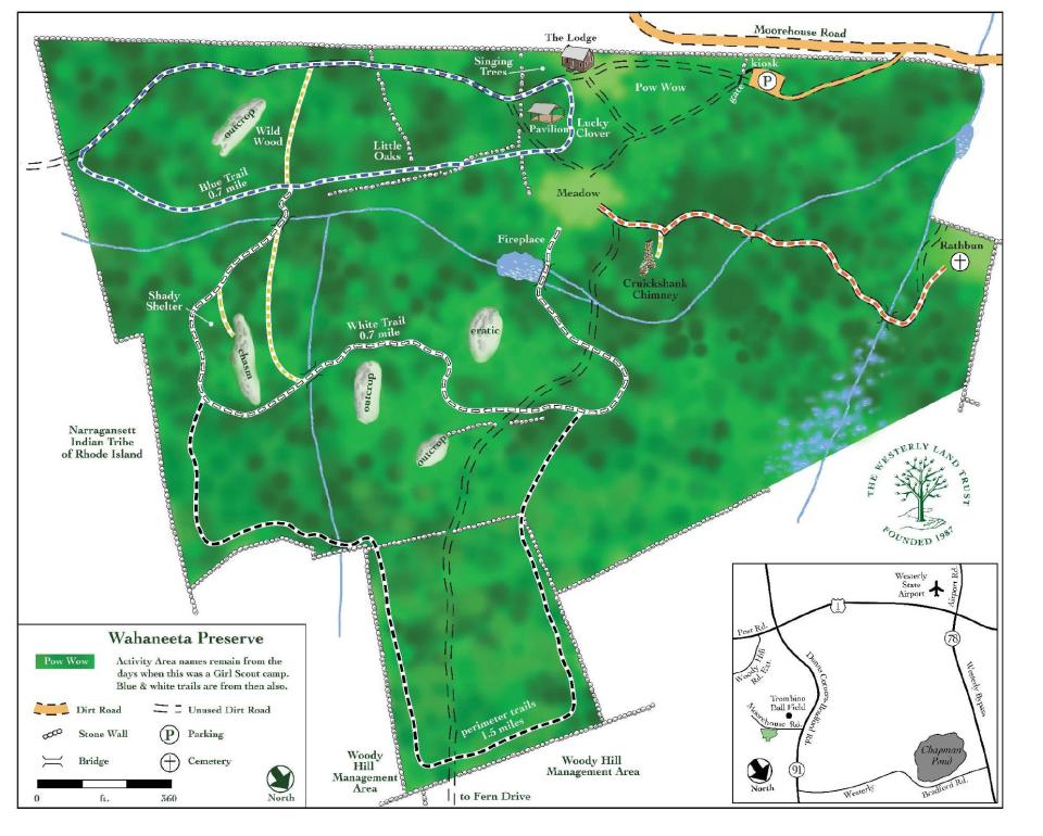
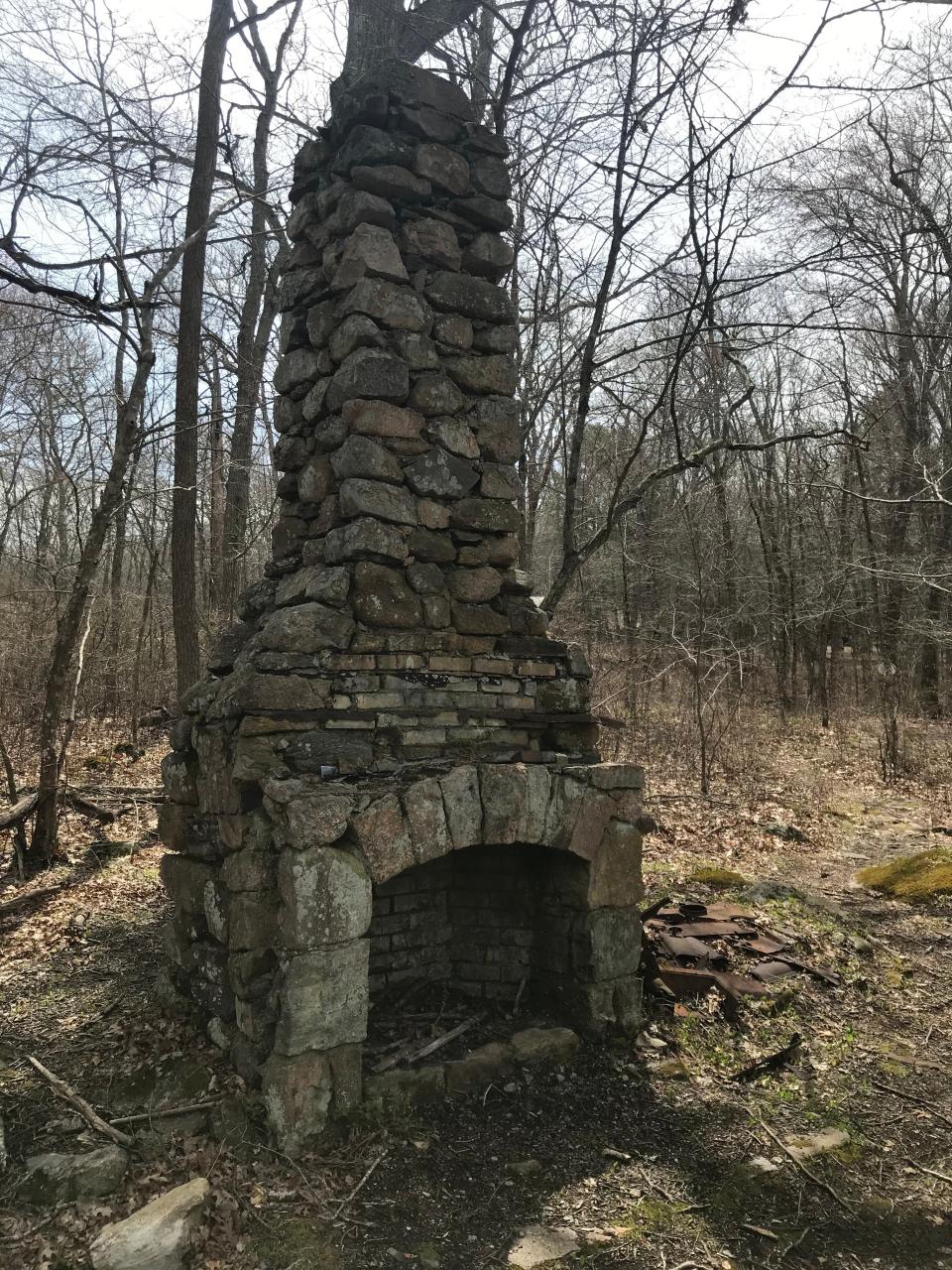
On the other side of the bridge is a large stone fireplace, probably once used by the Scouts for cookouts.
Walking RI: 5 great hikes with ocean views
Walking RI: At Trustom Pond in South Kingstown, silence is golden
We followed the path to the meadow and turned west on an orange-blazed trail that ran by a tall chimney on land once owned by Stuart Cruickshank, an immigrant from Scotland who worked at the Smith Quarry and later became chief engineer of the Bradford Dyeing Association. He sold 21 acres for $10 to the Scouts in 1941 to start the camp.
The trail crossed several bridges over streams lined with bright green skunk cabbage and ended at the Thomas Rathbun Ground, a small cemetery of 35 unlettered gravestones where Rathbun family members are buried.
Walking RI: A birder's paradise by the shore in Middletown
Walking RI: Splendid isolation and Native history at Wickaboxet Management Area
Walking RI: Retracing an Aussie Walkabout in George Washington Management Area
We retraced our steps to the meadow where we'd started after walking 5.6 miles over a little more than three hours. Before leaving, we took one last look at Wahaneeta, and it was not hard to imagine the Scouts exploring and enjoying the camp.
Over the decades, a lot has changed at Wahaneeta, but there is still much for all types of hikers to learn about the outdoors.
Trail Tip
During hunting season, all users of state management areas are required to wear a minimum of 200 square inches of solid fluorescent orange, such as a hat or vest, from April 16 to May 31. Violators are subject to a $100 fine.

John Kostrzewa, a former assistant managing editor/business at The Providence Journal, welcomes email at johnekostrzew@gmail.com.
This article originally appeared on The Providence Journal: Former Westerly, RI Girl Scout camp offers family-friendly hiking

