Walking RI: The haunting legacy of Tiverton's Fort Barton Woods
TIVERTON — The Sin and Flesh Brook that winds through Fort Barton Woods is one of the most intriguing places I’ve ever come across while hiking in Rhode Island.
The origin of the name dates back 350 years to King Philip’s War between the Colonists and Native Americans, a series of bloody battles marked by many atrocities.
In the deep woods here in 1676, Zoeth Howland, a Quaker preacher, was tortured and killed while traveling from his home in Dartmouth to visit a congregation in Newport. His mutilated body was found in an unnamed stream that became known as “Sinning Flesh River.” Over the years, the name evolved to Sin and Flesh Brook.
Walking RI: Ninigret National Wildlife Refuge harbors naval, tribal history
Walking RI: Visit A Civil War grave and remnants of a bygone RI railroad in Hopkinton
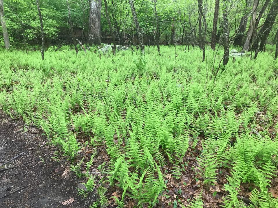
That violent history contrasts with the quiet, peaceful preserve I found when I recently hiked through the 98-acre sanctuary. The brook meanders through the isolated eastern side of the preserve under a dense canopy of oaks, maples and holly trees. Thick green ferns carpet the banks.
Scenic remains of a Revolutionary War lookout
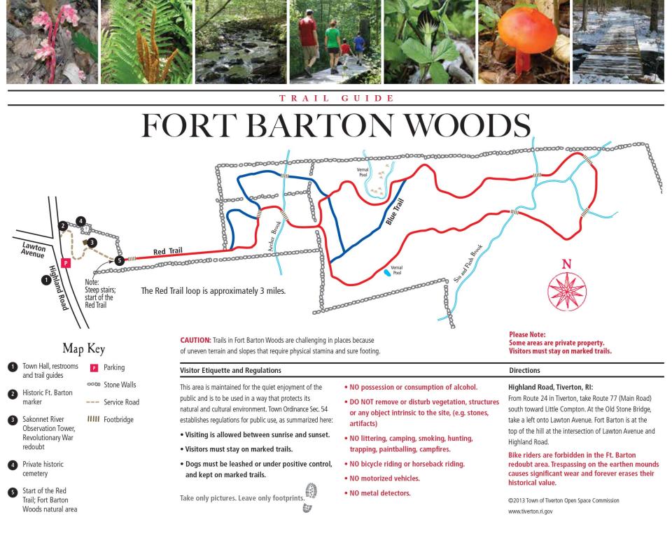
I set out to see the brook for myself early one foggy morning from the trailhead on the western side of the preserve, which is managed by the Tiverton Land Trust. I walked up a short, steep, paved pathway to the remains of fortified earthworks built on a granite outcropping on High Hill during the Revolutionary War. The redoubt on a bluff 110 feet above the Sakonnet River defended the narrow passage between Tiverton and Portsmouth. It also served as a lookout to check on the British occupation of Aquidneck Island from 1776 to 1779.
Walking RI: Family-friendly hiking at a former Girl Scout camp in Westerly
Walking RI: Looking for a great birdwatching spot? Try this former Navy site in North Kingstown
From the fortifications, Lt. Col. William Barton and a ragtag band of Colonists in 1777 launched a daring raid by boat around Prudence Island to Portsmouth. They rowed three boats in the dark of night through the British fleet, slipped ashore and captured British Gen. Richard Prescott in his quarters.
The raid had little strategic significance, but reports of Prescott being led off in his nightshirt swept through the Colonies and boosted the morale of the rebels.
To honor the raid’s leader, Tiverton Heights was renamed Fort Barton.
A 20-story observation tower now stands on the high ground next to a pole flying the American flag. I decided to save the climb to the top for later, after the fog had lifted.
Walking RI: 5 great hikes with ocean views
Walking RI: Immigrant war hero's legacy lives on at Glocester preserve
Ancient homeland of the Pocasset Tribe swept up in King Philip's War
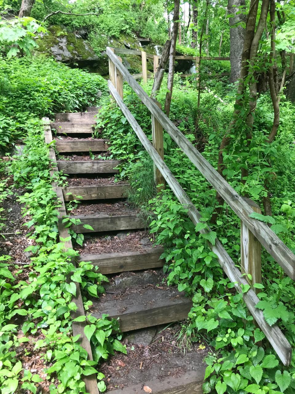
From behind the tower, I walked down a gravel path to a set of wooden steps that led down a steep embankment and into Fort Barton Woods.
I picked up the red-blazed trail and passed by a farm behind a stone wall on the right, where I heard a rooster crow before seeing chickens in a pen pecking for food. The path, rocky and rooted in places, ran up and down a small ridge before crossing a wooden bridge over Archer Brook.
Walking RI: A step-by-step guide to beautiful Stepstone Falls
Walking RI: Best place for a hike and osprey spotting? Try the Great Swamp in South Kingstown
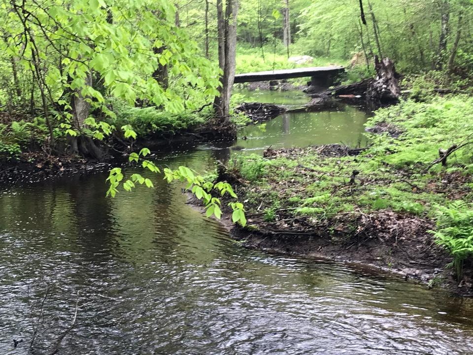
Continuing east under stands of holly, birch and black cherry trees, I crossed a stone wall and passed through a muddy area before getting a first glimpse of Sin and Flesh Brook, which meandered easily through the woods.
It was peaceful.
The Pocassets, part of the Wampanoag nation, lived and hunted here for thousands of years.
During King Philip’s War (1675-1676), they joined other tribes to fight the Colonists after an escalating series of disputes over land claims, tribal rights and cultural tensions. When the Colonists encroached on local lands, the Native Americans retaliated by raiding settlers’ homes and property. That led to more brutal clashes.
Two of the first armed engagements of King Philip’s War took place in Tiverton as the war spread throughout the region.
In December 1675, in what is now South Kingstown, the Colonists massacred 600 Native Americans, including women and children, and burned dwellings and food in what came to be called the Great Swamp Massacre. About 150 members of the Colonial militia died in the battle.
Walking RI: Exploring trail-blazer 'Vin' Gormley's playground in Charlestown
Walking RI: Trestle Trail in Coventry is a great spot for fitness training
In response, the Native Americans burned settlements and killed Colonists throughout Rhode Island. In 1676, Howland, the preacher, was found dead in Sin and Flesh Brook. Historians have found court records that named a Native American as his killer.
The war lasted until Canonchet, chief of the Narragansetts, and later, Metacomet, chief of the Pokanoket and also known as King Philip, were killed.
As the war ended, the Pocassets were driven from the land, which was granted to Colonists, in some cases for outstanding service during the war. Their farms dominated Tiverton for hundreds of years. The stone walls that crisscross Fort Barton Woods were probably constructed as property lines or barriers to keep livestock from wandering into swampy areas.
Peaceful yet eerie setting for a woodland walk
I paused and thought about all that history as I followed the red-blazed trail across a wooden bridge over the Sin and Flesh Brook, which flows southwest into Nannaquaket Pond. I crossed the winding brook three more times on wide, wooden-board bridges. At one bend in the river, in a darkened area heavily shaded by tall oaks, the only sound was the water rippling over stones in the shallow stream. It felt a bit eerie.
Walking RI: Seal-watching and scenic splendor at Rome Point in North Kingstown
Walking RI: Retracing Thoreau's 1854 hike through Providence
The trail bent north and then east, with a stone wall running parallel to the path.
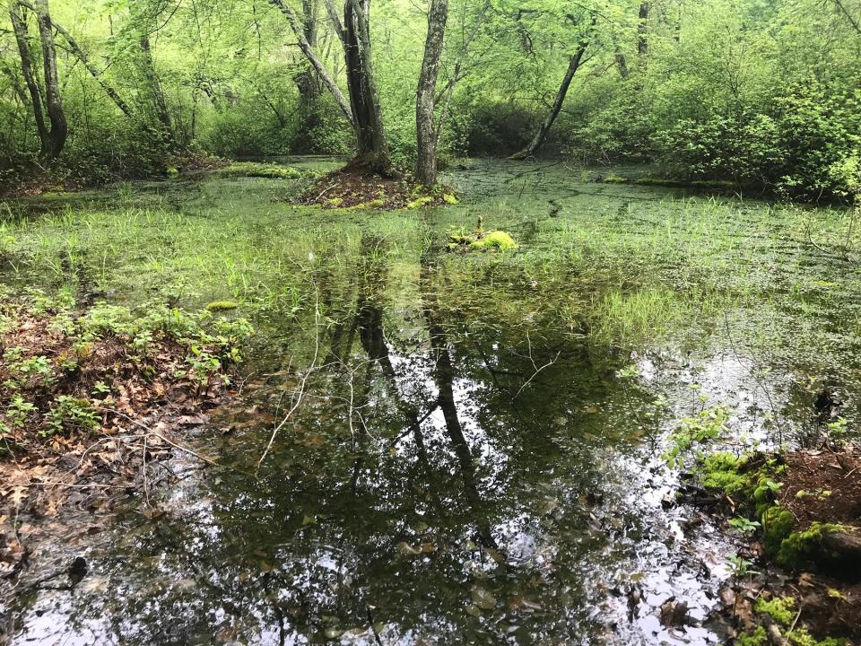
I passed through a rocky area of outcroppings and boulders before dipping down to some wetlands, including a placid, vernal pool with red maple and yellow birch trees growing on a small island in the middle. I heard the strum, a deep, banjo-like twang, of a frog.
At a junction, a blue-blazed cross trail opened on the left, but I continued straight on the red-blazed trail. When I reached a green-blazed trail on the right, I took it up a hillside and through what’s called Highland Woods. From there, I took a short path on the left and found a small, stone-lined cemetery with stones for members of the Manchester and Durfee families.
Walking RI: Take in the fragile beauty of Warren's Touisset Marsh during a coastal hike
Walking RI: Rediscover Providence's Roger Williams Park on a serene hike around its ponds
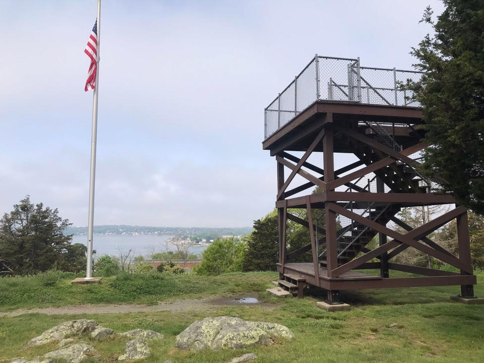
Panoramic views from observation tower
Just a short walk up the hillside on the left was the observation tower I'd passed when I started. The weather had cleared, and I climbed the wooden tower, erected in 1970, for a panoramic view west to the Sakonnet Passage and Mount Hope Bay. I could see the Sakonnet River Bridge and Roger Williams University far in the distance.
The area around me had once been a staging ground for 11,000 Colonial troops who were ferried across the passage in 1778 to fight in the Battle of Rhode Island on Aquidneck Island. Their assault was unsuccessful.
Walking RI: Exploring Big River, site of the flood that never was
Walking RI: At Trustom Pond in South Kingstown, silence is golden

When I was done studying the scene, I finished my walk of about 3.5 miles over two hours.
How did Sin and Flesh Brook get its name?
I was intrigued by what I had seen, though, and did some additional research into the meaning of “Sinning Flesh River” that later became Sin and Flesh Brook. Nobody really knows.
I did learn that Howland became a Quaker after speaking out publicly and harshly against the Puritans, whose clergy fined him, put him in the stocks and drove him from his home in Plymouth. So, does the name refer to a sinful man who was punished for his beliefs? Or is it as simple as the sinful murder of a peaceful preacher? Or does it mean something else altogether?
Walking RI: New conservation area in Coventry honors memory of late educator
Walking RI: Coastal views and prime bird-watching at Tiverton's Emilie Ruecker preserve
Walking RI: A birder's paradise by the shore in Middletown
Whatever the derivation, the name, and its history, are haunting and not easy to forget.

John Kostrzewa, a former assistant managing editor/business at The Providence Journal, welcomes email at johnekostrzewa@gmail.com
This article originally appeared on The Providence Journal: Hiking in RI: The haunting history of Tiverton's Fort Barton Woods

