Walking RI: Leave the noise behind at a wooded retreat in Richmond
RICHMOND — Willard and Esther Crawley bought a tract of old farmland and woods here in the 1930s as a weekend retreat from city life. Over the decades, they enjoyed walking through shady pine, oak and maple forests and along a tumbling brook. From a high point on the property, they could look out to the surrounding rural area.
After the Crawleys died, their descendants honored their wishes to preserve the land by selling it to local land trusts. They used the proceeds to help pay for the college educations of the Crawleys’ grandchildren.
Today, the Crawley Preserve offers hikers about three miles of trails on 99 acres that are managed by the Richmond Rural Preservation Land Trust and the South Kingstown Land Trust. About 84 of the acres are in Richmond and the rest are in South Kingstown.
Walking RI: Follow in the footsteps of Trappist monks in Cumberland
Walking RI: Tillinghast Pond's trails are part of something special and well worth a visit
No noise, except songbirds and a babbling stream
When I recently walked the paths, I enjoyed a secluded, heavily wooded hike far removed from urban life. There were no cars, no noise and no urban sprawl, just the sounds of songbirds in the trees and the ripple of a stream.
That’s what must have made the retreat special to the Crawleys.
To reach the trailhead, I drove across a bridge over the Queen River, passed Kenyon’s Grist Mill and followed Glen Rock Road to a small turnout on a hillside. An old cabin once stood there but was cleared to create a few spots for cars and a kiosk with a trail map.
I set out from the southern end of the lot on the blue-blazed Crawley Trail. After a short distance, behind a stone wall on the left, I saw overgrown stone foundations for a house, smaller outbuildings and a chimney. Some of the walls may have penned in sheep, cattle or horses. Town records show the land was owned in the 1800s by Asa B. Marshall, who was listed as a woodcutter.
The wide trail, rocky and rooted in places, runs up a hillside before it flattens out and narrows to a footpath along the southern border of the preserve.
Walking RI: Trolley line left its mark at Lincoln's Lime Rock Preserve
Walking RI: Mingle with birds, beavers, mink and more at Exeter's Fisherville Brook refuge
Evidence of damage from drought and insects
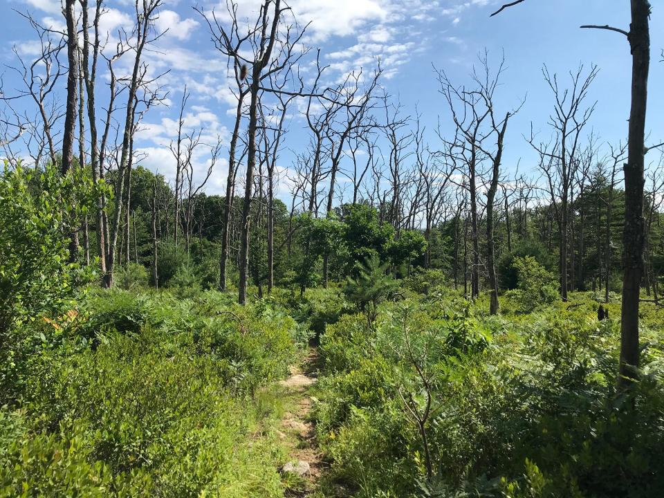
At a junction, I turned left on the red-blazed Red Fox Trail, which runs across a hillside dotted with defoliated oak trees, victims of drought or a spongy moth infestation.
Just ahead, the orange-blazed Box Turtle Trail opened on the left, and I took the loop over land that farmers had cleared years ago to grow crops in the fine, silty loam. When the farming ended, shrubs and trees took root to form a new forest.
At the southern end of the loop, I saw an electric fence for a horse farm, where a pony grazed in one of the back fields.
The trail led me under Northern red and white oaks and red maple trees to the high point of the property — about 340 feet above sea level. Pine Hill is just to the south.
Walking RI: Start your day on the right foot with a hike at Cranston's Curran State Park
Walking RI: The haunting legacy of Tiverton's Fort Barton Woods
On clear days in the winter, hikers report they can see the University of Rhode Island, but the dense trees and brush blocked my view.
I then headed north along a private property line and spotted a cabin just off the trail to the left. The path turned east, and I walked until I reached an intersection with the yellow-blazed Brook Trail and took it down a long slope with several interesting sites.
Just off the path, there are several seeps — moist or wet places where groundwater reaches the surface, usually from an underground aquifer. The seeps dry up during hot summers, but during other seasons they supply water to a variety of wetland plants that provide food to animals.
Vestiges remain of a devastating chestnut blight
In another section along the trail, white pines and white and black oaks line the path. Long ago, American chestnut trees, once one of the dominant species in New England, grew here. But a fungal blight killed off almost all mature chestnut trees in the region. Now, only chestnut sprouts or saplings remain, and they never grow very high before dying.
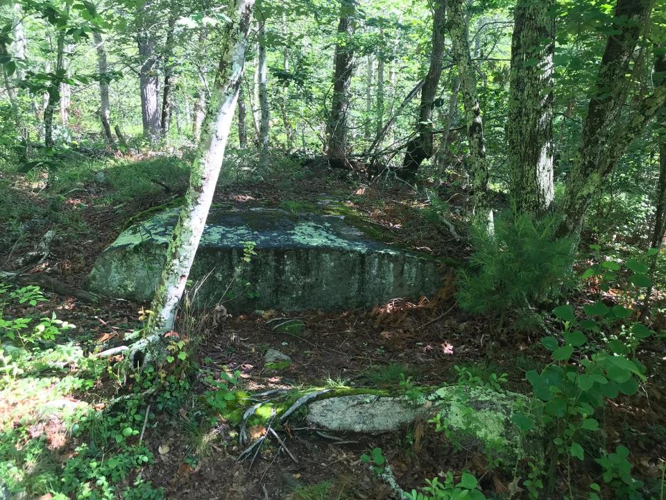
I also passed a series of ledges, outcrops and glacial erratics — boulders dropped by slowly retreating glaciers during the Ice Age. One of the huge erratics is perched on a ledge.
Walking RI: Ninigret National Wildlife Refuge harbors naval, tribal history
Walking RI: Visit A Civil War grave and remnants of a bygone RI railroad in Hopkinton
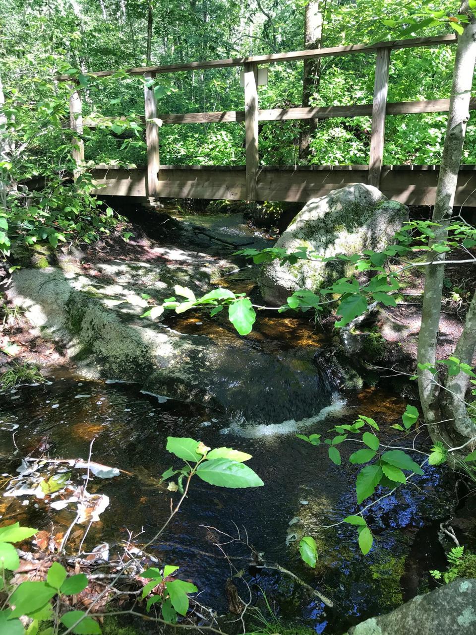
After a bit, the trail heads downhill, and I heard the first sounds of trickling water. A few steps later, I saw a wooden bridge over a narrow stream called Sandy’s Brook, which enters the property from the west and then runs southeast. I paused and studied the flowing water as well as the construction of the bridge. I measured the bridge, which was built on two long log supports, at 24 feet long by 4 feet wide.
Remnants of a former granite quarry
I continued on the yellow-blazed trail and noted the beech trees mixed with oaks, maples and pines before coming across huge slabs of bedrock, some covered with lichen and fungi, that seemed to have been cut on an angle. I learned later that the area was once a small quarry, and the locals used drills, chisels, hammers and wood pegs to break and split the granite and igneous rocks known as granitic gneiss.
The exposed bedrock was once deep within the earth. But over the course of millions of years it was worn down by erosion.
The yellow-blazed trail soon reached a second bridge, called the Lower Bridge, over Sandy’s Brook. The stream is fed by precipitation, groundwater and runoff from a 160-acre watershed, creating a lush area with vegetation called a riparian zone, a habitat rich in fruits and insects that serve as food for birds, reptiles and mammals.
Walking RI: Looking for a great birdwatching spot? Try this former Navy site in North Kingstown
Walking RI: Immigrant war hero's legacy lives on at Glocester preserve
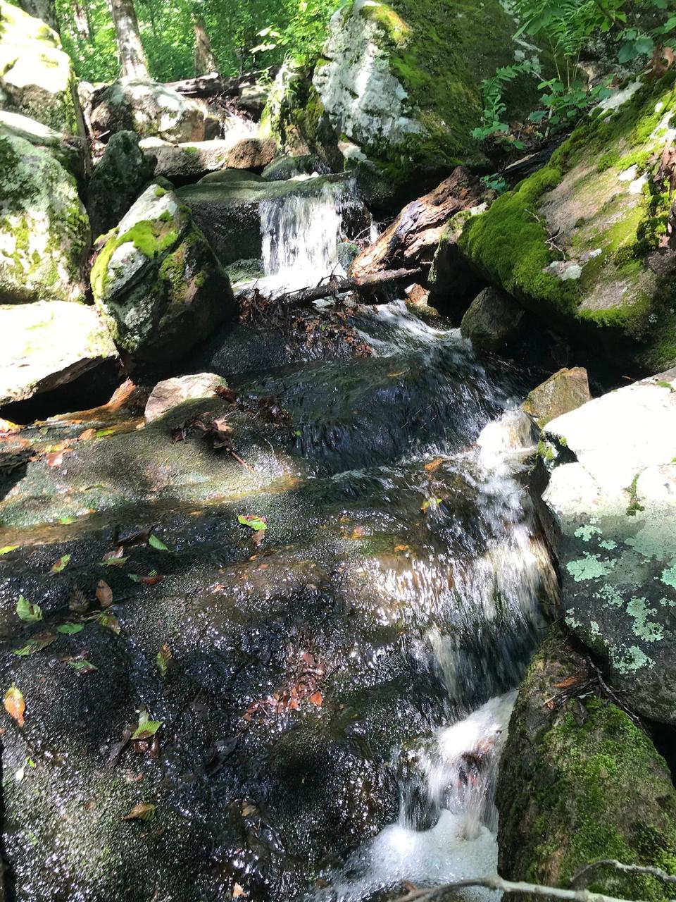
The path led me back to the trailhead, but there was still more to explore, so I set out again on the red-blazed Red Fox Trail. I headed west up a hillside until I reached a turn with a trail bench that overlooked an unnamed stream. The water spilled down a steep hillside, creating several mini-waterfalls. I took a break, sat on the bench and watched the cascades.
When it was time to head back, I picked up the white-blazed trail that opened across from the bench on the other side of the brook. There was no bridge here and I was careful to pick my way over moss- and lichen-covered stones smoothed by the flow of water. On the high ground on the other side of the stream, there’s another bench that offers a good look down a steep slope and into the gully cut by the brook.
I followed the white-blazed trail to the yellow-blazed trail that I had been on before and took it southeast back to the parking lot.
In all, I hiked 2.5 miles over 90 minutes.
Walking RI: A step-by-step guide to beautiful Stepstone Falls
Walking RI: Best place for a hike and osprey spotting? Try the Great Swamp in South Kingstown
Walking RI: Trestle Trail in Coventry is a great spot for fitness training
Notebooks filled with messages from other hikers
Back at the kiosk at the trailhead, I noticed two notebooks filled with hand-written messages from visitors. My favorites were those from children.
One read, “I liked the mini waterfalls the best. Rachel.”
Another, signed by “Justin, Addie (dog) and Angela,” said, “Our family found a big turtle on the Box Turtle Trail. Lots of fun.”
Those experiences, and the joy they brought the visitors, are probably just what the Crawleys had in mind.
Walking RI: Retracing Thoreau's 1854 hike through Providence
Walking RI: Rediscover Providence's Roger Williams Park on a serene hike around its ponds
Trail Tip
Prohibited activities at Crawley Preserve:
Use of mountain bikes or motorized vehicles.
Hunting, trapping or fishing.
Removal of dead wood or fallen branches.
Building fires, camping or remaining on the property after sunset.
Leaving any trash.

John Kostrzewa, a former assistant managing editor/business of The Providence Journal, welcomes email at johnekostrzewa@gmail.com.
This article originally appeared on The Providence Journal: Leave the noise behind while hiking at a wooded retreat in Richmond RI

