Walking RI: Mingle with birds, beavers, mink and more at Exeter's Fisherville Brook refuge
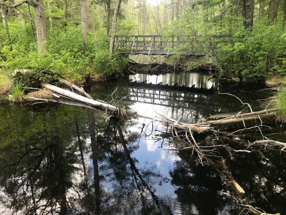
EXETER — An old mill pond with a footbridge on one end above a beaver dam and a waterfall over a stone dam at the other are among the special features at the Fisherville Brook Wildlife Refuge.
There are also a variety of birds to spot in a grassy, hillside pasture and, if you’re lucky, you may spot a mink by the water and streams. (I saw the birds but not the mink.)
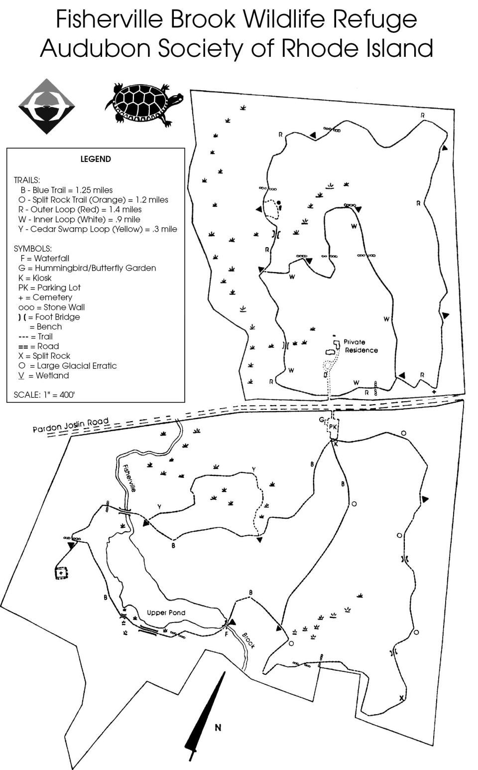
You also have several choices of trails.
One trail circles Upper Pond on the southern side of the 1,010-acre preserve managed by the Audubon Society of Rhode Island. It’s perfect for families and first-time hikers.
Walking RI: Start your day on the right foot with a hike at Cranston's Curran State Park
Walking RI: The haunting legacy of Tiverton's Fort Barton Woods
There’s another loop trail on the northern side of the refuge that’s a bit more rugged and runs by ridges, small hills, brooks and huge glacial erratics left from the Ice Age.
I set out from the parking lot and stopped at a kiosk to check the map. I studied the color-coded trails, took a cellphone picture and chose the blue-blazed path headed south.
Walking RI: Visit A Civil War grave and remnants of a bygone RI railroad in Hopkinton
Walking RI: Ninigret National Wildlife Refuge harbors naval, tribal history
Walking RI: 5 great hikes with ocean views
The wide trail rises and falls over small ridges and below tall white pine trees. At a junction with the yellow-blazed trail, I took the short loop along the edge of a white cedar swamp before returning to the blue-blazed trail.
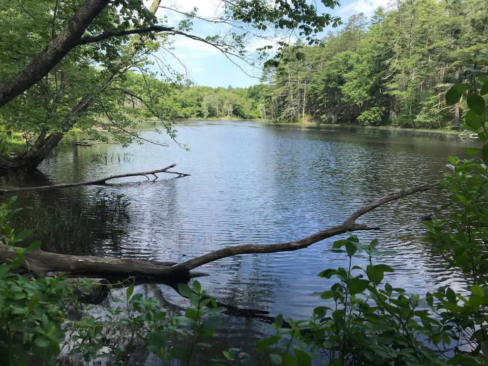
A little further down the path, there’s a sitting bench and a short side spur on the left to a flat ledge where I’ve seen families pause for a break and look down the slope at the small, L-shaped mill pond.
Evidence of busy beavers at work
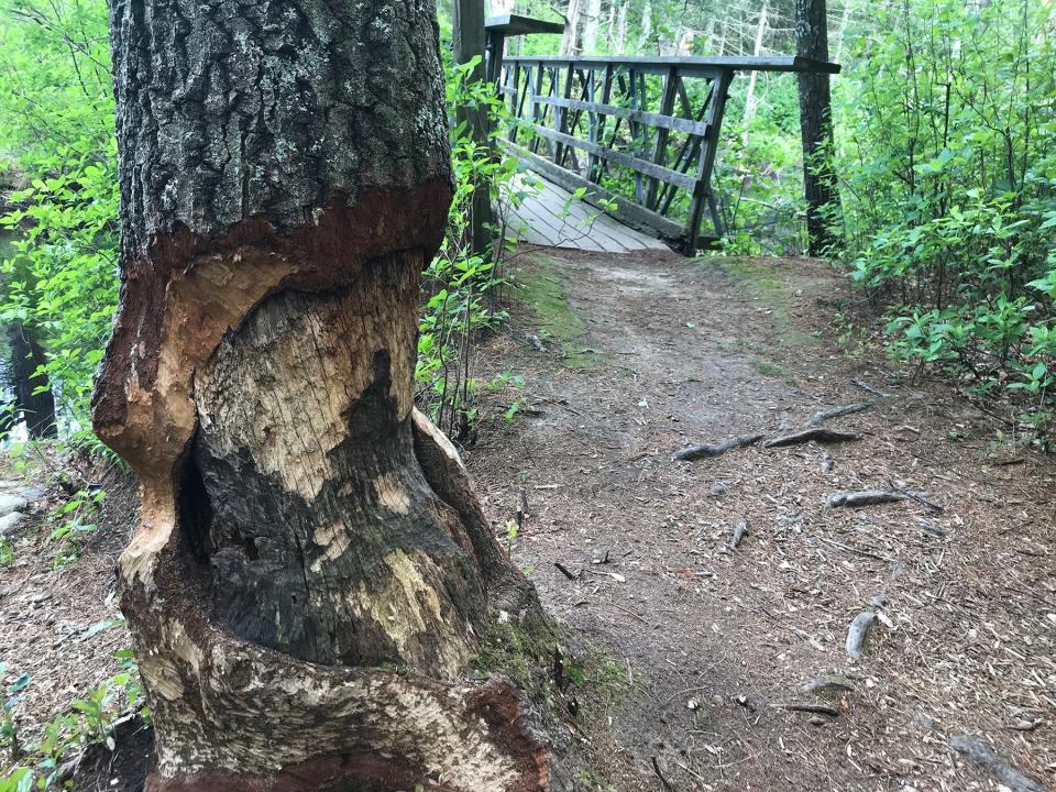
After a gentle descent, you’ll come to a wooden footbridge over Fisherville Brook, which feeds the pond from the north. If you look down, you’ll see the beaver activity that has blocked some of the water flow into the pond and created a large swampy area upstream. And don’t miss the tree gnawed almost all the way through at the start of the bridge.
Trail stewards periodically clear out the branches and mud dams built by the beavers that sometimes flood the trails. The beavers are most active in the fall, when they construct dams to raise the water level before winter so they can get to their food storage under the ice.
Hikers also report seeing or hearing otters, muskrats, fox, deer, wood frogs, spring peepers and minks. I was especially interested in the minks, which have long, skinny chocolate-brown bodies and live near water, where they dig burrows in riverbanks or use old muskrat or beaver dens. They eat muskrats, frogs, fish and other small animals. But I didn’t see one on this walk.
Walking RI: Family-friendly hiking at a former Girl Scout camp in Westerly
Walking RI: Looking for a great birdwatching spot? Try this former Navy site in North Kingstown
On the far side of the bridge, the trail skirts the lily-pad-covered Upper Pond, with several pastures on a hillside on the right, and several lean-tos built with thick branches under pine trees at the shoreline.
A sign marks a side trail for a short walk up a hill on the right to a large, grassy field. A sign says it is mowed once a year in the fall to preserve the mix of grasses and forbs (herbaceous flowering plants) that are a natural habitat for plants and grassland animals. Without regular mowing, the fields would revert to forest land and be dominated in 15 or 20 years by shrubs and trees.
Walking RI: A step-by-step guide to beautiful Stepstone Falls
Walking RI: Best place for a hike and osprey spotting? Try the Great Swamp in South Kingstown
In the middle of the meadow is a raised, stone-wall-lined graveyard on land that was once the old John Gardner (1754-1837) homestead and later the Reuben Brown farm. The headstones mark graves from the 1800s and 1900s for members of the Gardner, Sweet, Bailey and Hall families.
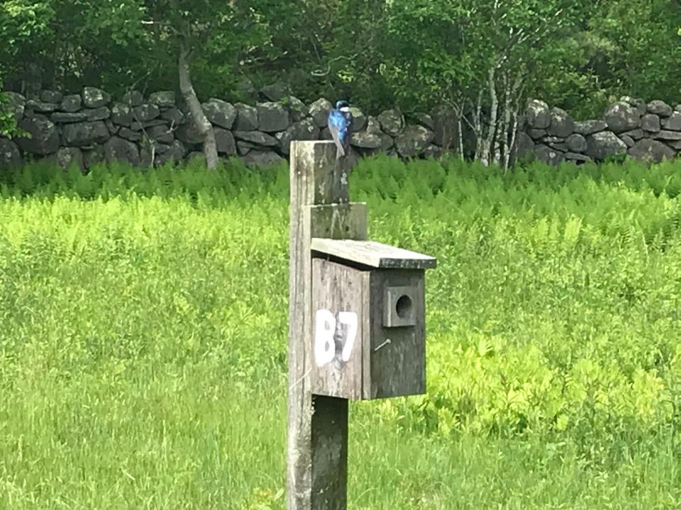
Nesting boxes for a variety of birds
The graveyard is encircled with nesting boxes of various shapes and heights with different-sized holes to attract a variety of birds, said Laura Carberry, refuge manager.
The small wooden boxes are home to tree swallows and bluebirds. I took some time to watch a small tree swallow with blue feathers perched on top of one.
An odd-shaped structure, called a gourd, with bulbous white boxes arranged in a ring at the top of a tall pole is for purple martins, which like to live in a community. A nesting pair had settled in one of the gourds.
Walking RI: Exploring trail-blazer 'Vin' Gormley's playground in Charlestown
Walking RI: Trestle Trail in Coventry is a great spot for fitness training
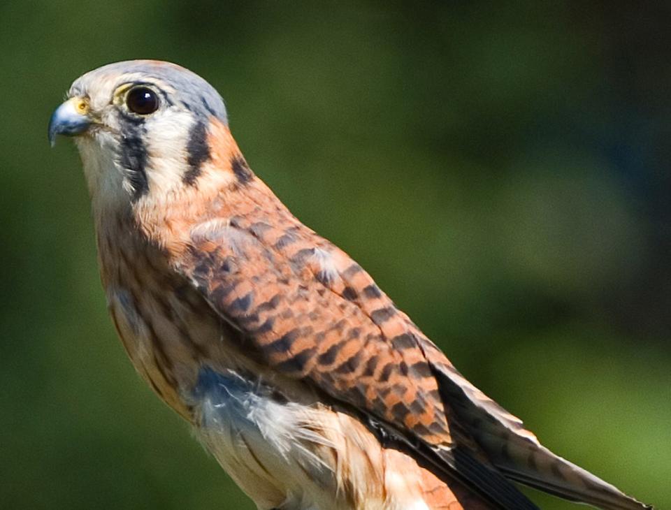
Another tall pole with a box on top is for the American kestrel, the smallest of falcons, which like to live in cavities.
While watching the birds, I surveyed the pasture and the trees, including a few cedars, and the stone walls that surround it. A large farmhouse is about 400 feet higher up the hill. I heard a dog bark.
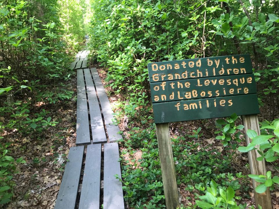
Returning to the blue-blazed trail, I continued on the path around the pond and walked over a lengthy set of bridges made from recycled plastic planks over lowlands that are dry now but sometimes flood from beaver activity and during rainy seasons.
Carberry said a woman from Exeter who loved the refuge donated the planks to extend an existing boardwalk. An Eagle Scout built the extension and, at the woman’s request, put up a sign so hikers and her grandchildren would know of their donation.
It reads: “Donated by the grandchildren of the Levesque and LaBossiere families.”
Walking RI: Stunning views of two states on Exeter's Hemlock Ledges Trail
Walking RI: Retracing Thoreau's 1854 hike through Providence
Walking RI: Unwind on Mowry preserve's peaceful trails in Smithfield
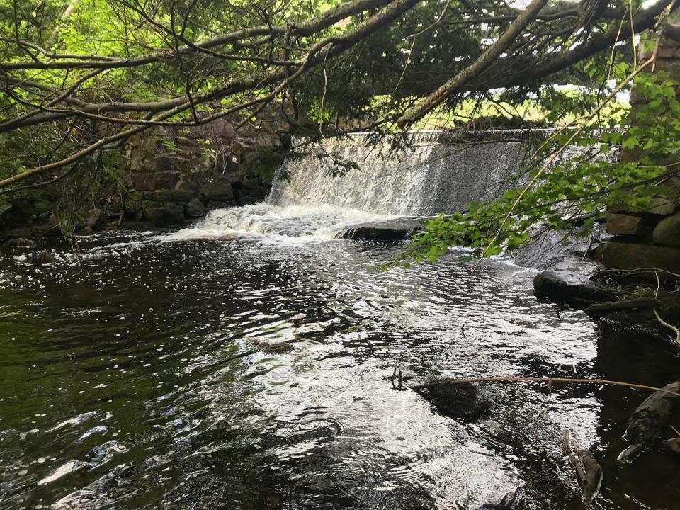
The trail skirts the pond before crossing a wooden bridge over a dam that forms a waterfall where outflow from the pond tumbles about 8 feet to a spillway. The dam was built to create Upper Pond and includes a stone-block foundation and what looks like a sluice gate. I read that a sawmill and later a cotton spinning mill once operated there. During the winter, ice blocks were cut from the pond.
The water flows into Fisherville Brook, which runs south under Route 102 to merge with Sodom Brook before entering the Queen River. Along the way, it passes through Fisherville, once a small mill town that thrived in the mid-19th century. The remains, including a gristmill, sawmill and a Cape-style house, were listed on the National Register of Historic Places in 1980.
Walking RI: Take in the fragile beauty of Warren's Touisset Marsh during a coastal hike
Walking RI: Rediscover Providence's Roger Williams Park on a serene hike around its ponds
The trail crossed the walkway over the dam and reached a junction in about 50 yards. The blue-blazed trail goes left and returns to the parking lot. I turned right on the orange-blazed trail, which crossed two small bridges over streams and passed under oak and beech trees and by several fields before returning to the lot where I'd started.
The northern loop: Mysterious cairns and glacial erratics
Walking north across Pardon Joslin Road, I set out for the second loop through the other half of the preserve. I walked a few yards up a driveway for a private residence and turned right on the red-blazed, pine-needle-covered trail that ran up a small hill. The woods here were dense and quiet.
There are several sitting benches along the trail that passes through tunnels of mountain laurel in several places.
Walking RI: Losing the trail and finding a mystery in Exeter
Walking RI: Exploring Big River, site of the flood that never was
At the northern section of the path, I noted several small cairns in no apparent order. I’ve seen those before in Exeter, Hopkinton and Coventry. Historians say they may have been built from rocks cleared from fields by early settlers or by Native Americans for ceremonial purposes.
Nobody’s sure.
The trail turned south and, at a bench, I went left on a short unmarked loop by a stone wall and some of the largest glacial erratics on the property. A hiker’s report said a small, unmarked graveyard is nearby, but I couldn’t find it. But I did see what may be small kettle holes formed when indentations in the land filled with chunks of glacial ice that melted, creating the depressions.
I returned to the red-blazed trail. A white-blazed inner loop trail opened on the left, but I stayed straight, crossed a small bridge and passed what looked like an old nature study course for children. I spotted a house and shed on the left before walking downhill and back to where I'd started.
Walking RI: At Trustom Pond in South Kingstown, silence is golden
Walking RI: Coastal views and prime bird-watching at Tiverton's Emilie Ruecker preserve
Walking RI: A birder's paradise by the shore in Middletown
In all, I hiked about 4 miles over two hours.
Before you leave Fisherville, check out the Pollinator Garden just off the parking lot. It’s planted with flowers and plants to attract and support pollinators, such as bees and butterflies, and curb the decline in their population.
It’s a nice way to end an enjoyable and educational walk.
Trail Tip
The Audubon Society advises that wildlife refuges are places to walk, observe, photograph and learn about plants and animals while respecting the land, solitude and other hikers. They are not a place to run, make noise, picnic, camp, walk dogs, ride horses, drive motorized vehicles, leave refuse, smoke, drink, hunt, fish or trap.

John Kostrzewa, a former assistant managing editor/business at The Providence Journal, welcomes email at johnekostrzewa@gmal.com.
This article originally appeared on The Providence Journal: Hike among wildlife at Exeter's Fisherville Brook preserve

