Severe weather in forecast for North Texas Tuesday and Wednesday. Here’s what we know
North Texans should brace for severe weather Tuesday evening as a warm front moves into the region, according to the National Weather Service in Fort Worth.
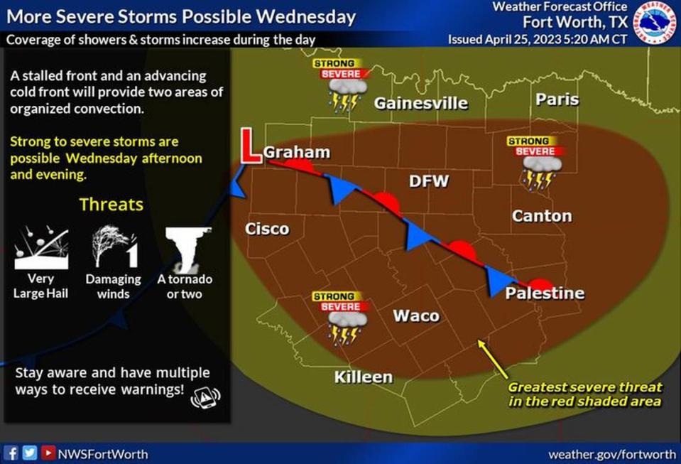
Large hail, damaging winds and a few tornadoes are all possible, according to the weather service.
A first round of storms is forecast across Central Texas beginning around 6 p.m. Tuesday with mainly a threat for large hail. Additional storms could spread into North Texas, including Dallas and Fort Worth, later Tuesday night into early Wednesday morning. Storms in North Texas are forecast between about 9 p.m. and 6 a.m., with threats for both hail and strong wind gusts. There is a low tornado threat as well, according to the weather service.
Temperatures are expected to be in the 60s to 70s Tuesday afternoon, with gusty winds expected to reach 15 mph to 20 mph. Damaging winds are most likely to be localized south of Interstate 30 and happen in the evening, according to the National Weather Service.
Around round of storms, including severe weather, is expected beginning Wednesday afternoon with hail, damaging winds and isolated tornadoes. Dallas-Fort Worth, areas to the west, east and south are the most likely areas for severe weather Wednesday along and ahead of an approaching cold front.
Clear skies are predicted most of the day Thursday before a return of storms Friday afternoon and evening. At this time, widespread severe weather is not expected on Friday. However, stronger storms will be capable of producing hail and gusty winds.
3-Day Storm Outlook
This map shows the 3-day weather outlook for storms by the National Weather Service's Storm Prediction Center. Sources: National Weather Service, Esri.
Current Temperatures
Current temperatures and weather data from NOAA weather stations updated hourly. Tap on the map for current weather conditions, including humidity, wind speed. and direction. Data provided by NOAA and Esri.

