Warm Great Lakes to serve as fuel for multiple rounds of lake-effect snow


A storm bringing accumulating snow to portions of the northern United States and southern Canada will also set the stage for lake-effect snow into the early week across the Great Lakes. As colder air rushes east behind this storm, the lake-effect snow machine will rev to life downwind of the lakes.
Forecasters say sandwiched between two separate periods of lake-effect snow could be another storm that also brings snow to more than just the lake-effect snow belts. The net effect of it all will result in the longest stretch of wintry weather thus far across the region.
"There will be two distinct periods where true lake effect is expected to occur downwind of the lakes," said AccuWeather Senior Meteorologist Brian Wimer. The first occurred Saturday night, primarily across Michigan downwind of Lake Superior and Ontario.
CLICK HERE FOR THE FREE ACCUWEATHER APP
However, there were not many significant accumulations with the first batch of lake-effect snow, and the reason has to do with the lakes themselves.
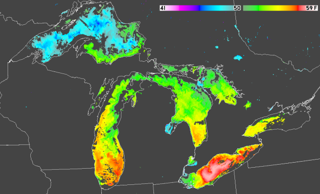
Even though the United States is deep into autumn, the Great Lakes have not gotten the message that summer is over.
" As of Nov. 11, each of the Great Lakes is running hot for this time of year, compared to the 1995-2020 average, by 3 to 5 degrees Fahrenheit," AccuWeather Meteorologist and Senior Weather Editor Jesse Ferrell explained.
 |
Clear skies in the early morning of 10 November 2021 allowed mapping of lake surface temperatures from VIIRS satellite data acquired at CIMSS. Much of Lake Superior was in the mid-40s F while much of central Lake Erie is in the upper 50s F. (SSEC/CIMSS) |
"Shallower waters nearshore are running even higher, with Buffalo's water temperature at 54 degrees Fahrenheit, 10 degrees above its November average."
AccuWeather forecasters say an Alberta clipper will sweep from the northern Plains across the Great Lakes. This will once again disrupt the lake-effect snow across the region as the winds shift yet again, but the clipper could also bring widespread accumulating snow across parts of the region.
"Certain atmospheric conditions need to fall into place in order for lake-effect snow to occur. One component is that the air that blows across the Great Lakes has to be significantly colder than the water in the lakes," explained AccuWeather Meteorologist Mary Gilbert. "However, another is that the wind direction is largely uniform through a large layer of the atmosphere."
The changes in wind speed and direction in height - or lack thereof - are called wind shear. While wind shear is conducive for weather features such as severe thunderstorms, other events, like hurricanes and lake-effect snow, require lower wind shear to be able to become more organized.
"Wind shear in lake effect essentially 'shreds' lake-effect bands apart and prevents them from becoming well organized," Wimer explained.
However, while this clipper sweeping across the Great Lakes from Sunday to Sunday night may cause wind shear that will disrupt lake-effect snow bands, it can bring its own accumulating snow which could cause roads to become slippery across the region. This clipper will exit the Great Lakes to the east by late Sunday and usher in a shot of even colder air, which will then allow the lake-effect machine to ramp back up again.
 |
As this colder air sweeps in, the lake temperature will become less of a factor, and even communities near the lakeshore are expected to see all snow from Sunday night into Monday night. Because of the very large difference between the air temperature and lake temperature, the lake-effect snow with this round could become particularly heavy.
"Areas downwind of the eastern Great Lakes, from southern Ontario into parts of northeastern Ohio, northwestern Pennsylvania and upstate New York, could bear the brunt of this second round," Wimer said.
While the next several days will feature a frequently changing weather pattern, featuring visits from low pressure combined with lake effect, some communities that receive the most persistent snow from either the clipper storm, lake effect or both could end up with a foot or more of snow over several days.
 |
Brian Cintron walks in his snow-bound south Buffalo neighborhood on Thursday, Nov. 20, 2014, in Buffalo, N.Y. (AP Photo/Mike Groll, File) |
"With all things considered, a large portion of the Great Lakes region will likely receive at least a coating of snow at some point in the coming days. In areas that get several rounds of snow across several days, snow could accumulate at least several inches," Wimer said.
Throughout the Great Lakes, residents will need to be alert for potentially hazardous, rapidly changing conditions. Even those simply traversing the region on major routes such as I-80 or I-90 should be prepared for pockets of slippery road conditions and reduced visibility.
 |
One particularly dangerous hazard that could arise from this event is sudden snow squalls, which can quickly reduce visibility to near zero and create icy and snow-covered roads with little warning.
Since it's still late in the fall, most roads have not been treated for snow and ice yet, which could further elevate the potential for hazardous road conditions as crews work to catch up and treat all of the roads. The prospect of rain at times leading up to the event can also make it harder to adequately treat roads, as road crews have less time to try to pre-treat roads in advance since treatment could just be washed away by rain.
While this will be the most prolonged taste of winter thus far for most in the Great Lakes, a reprieve is on the horizon. Milder weather will return during the middle of this week, which will help to melt snow and ease the chill.
For the latest weather news check back on AccuWeather.com. Watch the AccuWeather Network on DIRECTV, Frontier, Spectrum, fuboTV, Philo, and Verizon Fios. AccuWeather Now is now available on your preferred streaming platform.
