In a warming world, 'Cat 6' hurricanes could soon be coming to a coast near you
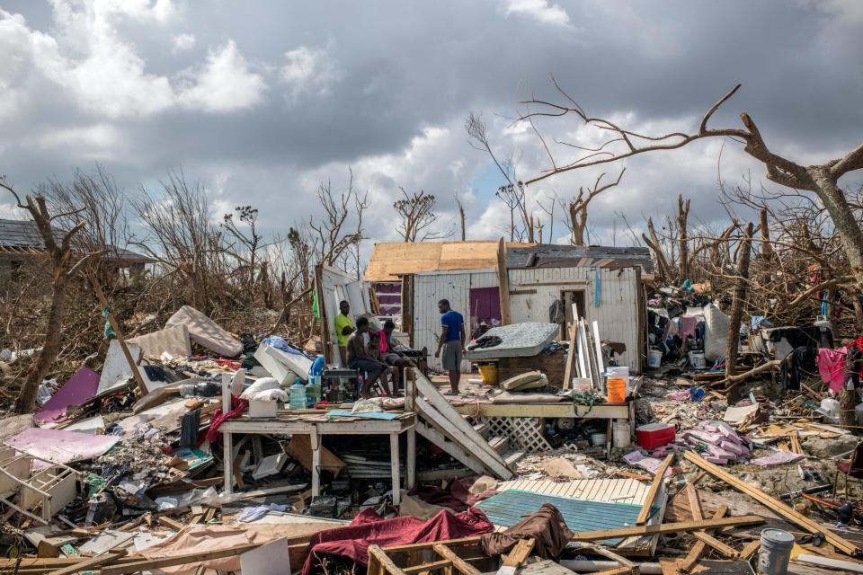
A few days before Hurricane Dorian slammed into Ocracoke Island and the southern Outer Banks in September 2019, the massive storm was packing winds of 185 mph as it devastated the Bahamas.
Dorian's development into a "superstorm," tying the record for the strongest Atlantic hurricane at the time of its Bahamas landfall, is no longer an unusual event. Recent storms with names like Katrina, Ivan and Matthew have all had winds that topped 160 mph, surging well past the Category 5 designation on the Saffir-Simpson Hurricane Wind Scale, which is used to identify the strongest storms in the world that have sustained winds of 157 mph or higher.
And with researchers forecasting climate change to produce more of these "superstorms" in the future as the planet continues to warm, some climate scientists are suggesting that a "Category 6" be added to the wind scale.

One of those is Dr. Michael Mann, director of the Earth System Science Center at Penn State University.
"It has been argued by some that there’s no need for a higher category than '5' because a '5' causes total destruction," he said in an email. "That’s less true now with the more resilient infrastructure that we’re creating, and there is a qualitative difference in the impact of a 157 mph weak Cat 5 and a 185 mph monster Cat 5."
On the current scale, a storm is classified as a Category 1 hurricane when its sustained winds are between 74 and 95 mph. The "Cat" level then increases every 15 to 25 mph until it maxes out at Category 5, used to describe storms with winds of 157 mph or greater.
More: On the Outer Banks, structures rise and fall as climate change looms
Mann argues that just saying a storm is a Cat 5 doesn't convey all of the dangerous impacts a super hurricane can pack, namely in the form of massive storm surge and precipitation events dumping tremendous amount of water on areas over a very short period of time.
But the need to add a new wind category isn't shared by all meteorologists.
Dr. Lian Xie, professor of marine, earth and atmospheric sciences at N.C. State University, said he didn't support the push since such events are still relatively rare and the benefits of doing so are unclear.
"Although adding a Category 6 may get the attention of the public on the present and future danger of super hurricanes, it can also mislead the public to focus too much on the impact of wind speed," he said in an email. "In fact, recent studies indicate that in a warmer environment, the atmosphere would be able to hold more moisture, and hence leading to increased precipitation from hurricanes."
Mann, however, said the new category would just be following the reality we're already seeing on the ground, not putting the cart before the horse. That includes a growing body of research that shows a storm's potential maximum intensity increases by about 23% for each 1 degree Celsius (1.8 Fahrenheit) of warming over pre-Industrial Revolution temperatures. The planet crossed that 1 degree threshold late last decade. Climatologists warn that on our current track of greenhouse gas usage, the Earth could see up to a 3 degree Celsius (5.4 F) warming by 2100.
Related: Dire climate report is a call to action. What individuals can do to make a difference
"It’s not a coincidence that the strongest hurricanes and typhoons ever observed globally, Patricia in 2015, and in both hemispheres, Patricia in the Northern Hemisphere and Winston in 2016 in the Southern Hemisphere, were within the past decade," Mann said. In October 2015, Patricia made landfall along the Pacific coast of Mexico with maximum sustained winds of 215 mph.
Perhaps the most important body when it comes to hurricane forecasting also is casting doubt about the usefulness of creating an additional wind speed category.
"At the National Hurricane Center, we've tried to steer the focus toward the individual hazards, which include storm surge, wind, rainfall, tornadoes and rip currents, instead of the particular category of the storm, which only provides information about the hazard from wind," said Dennis Feltgen, spokesman for the National Hurricane Center, in an email. "Category 5 on the Saffir-Simpson scale already captures 'Catastrophic Damage' from wind, so it's not clear that there would be a need for another category even if storms were to get stronger."
Living shorelines: Along the N.C. coast, preparing for rising waters with natural remedies
He added that 90% of hurricane-related deaths in the U.S. are caused by water-driven events, such as storm surge and flooding, not from damage due to strong winds.
While Mann and Xie might disagree on the need for a new category class, one aspect of forecasting hurricanes that they agree on is that the current storm reporting system doesn't factor in all of the dangerous conditions they can present, namely that size matters.
While two storms might have similar wind speeds, the researchers said storm size and intensity can make a huge difference in the damage potential from wind, flooding and storm surge.
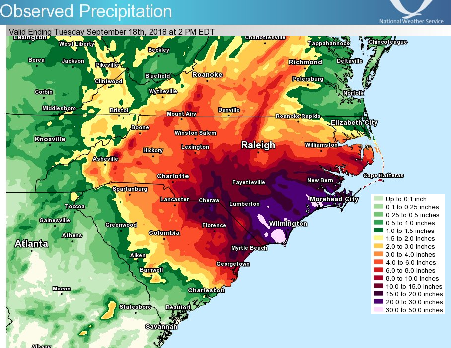
Hurricane Florence, for example, was only a Cat 1 storm when it made landfall at Wrightsville Beach in September 2018. But the slow-moving storm devastated much of Eastern North Carolina with record-setting rainfall dumping more than 30 inches in places and storm surge impacts amplified by sea-level rise.
"Until these important missing factors are considered, adding a Category 6 classification may do more harm than good in terms of raising the public’s awareness of how dangerous future storms can be," Xie said.
Testing 200 mph winds
Bigger storms packing stronger winds, increased storm surge risk, and dumping more rain on areas isn't the only bad news about our future hurricanes.
"Some of our research suggests that climate change may actually be pushing the tracks poleward, so that storms that might have, say, been headed toward New York City in the past are more likely to landfall on the New England coast," Mann said.
Rising seas: How rising seas could bring new challenges for two big Wilmington infrastructure projects
Faced with stronger and potentially more frequent storms threatening the U.S. mainland in the coming years and decades, the federal government is
In January the National Science Foundation (NSF) awarded a $12.8 million grant to Florida International University for a testing facility capable of wind speeds of up to 200 mph, combined with a water basin to simulate storm surge and wave action.
Joy Pauschke, program director of NSF's Division of Civil, Mechanical, and Manufacturing Innovation, said the goal of the new facility won't be to just document the worst that Mother Nature can bring, but transform that research into building more storm-resilient and prepared communities.
The new facility will allow researchers to test how powerful winds and water surges can increase loads on structures on a scale that isn't currently possible.
"It will allow us to design structures and retrofit existing buildings and infrastructure to better survive these conditions, and that's really exciting," Pauschke said.
Mann said any changes or innovations that can help communicate the grave threat posed by these storms is a win-win for emergency officials and residents potentially in harms way.
![Hurricane Florence brings storm surges and flooding to sections of historic New Bern. Areas near the Trent and Neuse River are affected by major storm damage and piled debris. [Gray Whitley / Sun Journal Staff]](https://s.yimg.com/ny/api/res/1.2/tQd0llRnfJF07hzKOBBiyw--/YXBwaWQ9aGlnaGxhbmRlcjt3PTk2MDtoPTY2MA--/https://media.zenfs.com/en/star-news/85a1f36c3ae04772ed8a6b9d1b3a3a0b)
In 2017, Mann recalled visiting First Presbyterian Church in New Bern to give a talk about the threat posed to coastal North Carolina by sea-level rise and the specter of stronger hurricanes.
A year later, Florence flooded the church just a few blocks from the Neuse River.
"The intensity of the storm, coastal flooding potential and inland flooding potential were all boosted by the warmer oceans," Mann said. "That's not going to change."
Reporter Gareth McGrath can be reached at GMcGrath@Gannett.com or @GarethMcGrathSN on Twitter. This story was produced with financial support from 1Earth Fund and the Prentice Foundation. The USA TODAY Network maintains full editorial control of the work.
This article originally appeared on Wilmington StarNews: Super hurricanes have some researchers pushing for a Cat 6 designation

