Warning: Canton weather may be severe on Tuesday, with damaging wind gusts, tornado chance
CANTON ‒ Mild weather is in the forecast for today, but that could change by Tuesday when there is a chance for severe thunderstorms, according to the National Weather Service.
Today's high temperature is forecast to be near 72 degrees with a northeast wind around 7 mph.
Monday night is expected to bring a chance of showers before 2 a.m., then a slight chance of showers after 3 a.m. It will be mostly cloudy with a low around 54 and northeast wind at 5 to 7 mph. The chance of precipitation is 30%. New precipitation amounts of less than a tenth of an inch are possible.
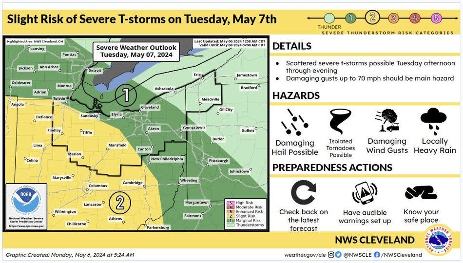
The Akron-Canton area has a marginal risk of severe thunderstorms from Tuesday afternoon through evening. Damaging wind gusts up to 70 mph should be the main hazard. Isolated tornadoes and damaging hail the size of quarters are also possible. Areas to the southwest, including Holmes County and areas west and south of Wooster, are at a greater risk.
On Tuesday, showers are expected, mainly after 3 p.m. The high will be near 77. The chance of precipitation is 80%. New precipitation amounts of less than a tenth of an inch possible.
Tuesday night will bring showers and possibly a thunderstorm, mainly before 2 a.m., then a slight chance of showers and thunderstorms after 2 a.m. The low will be around 62. The chance of precipitation is 80%. New rainfall amounts will be between a tenth and quarter of an inch, except higher amounts will be possible in thunderstorms.
'It's part of what we do:' Stark County EMA assists tornado recovery in Logan County
What's the Canton weather forecast?
Here's what the National Weather Service predicts through Sunday:
Wednesday: Mostly sunny, with a high near 80. At night, a chance of showers and thunderstorms, then showers likely and possibly a thunderstorm after 2 a.m. Mostly cloudy, with a low around 60. Chance of precipitation is 70%.
Thursday: Showers likely and possibly a thunderstorm. Mostly cloudy, with a high near 74. Chance of precipitation is 70%. Night will bring a chance of showers and thunderstorms. Mostly cloudy, with a low around 50. Chance of precipitation is 40%.
Friday: A chance of showers. Partly sunny, with a high near 61. Chance of precipitation is 40%. At night, partly cloudy, with a low around 45.
Saturday: Mostly sunny, with a high near 66. At night, a chance of showers. Mostly cloudy, with a low around 48. Chance of precipitation is 30%.
Sunday: A chance of showers. Partly sunny, with a high near 65. Chance of precipitation is 40%.
This article originally appeared on The Repository: Canton weather calls for damaging wind, possible tornado on Tuesday

