Washington, Iron counties get more representation in Legislature's proposed redistricting maps

Utah lawmakers passed four redistricting maps on Wednesday despite criticisms the maps were "gerrymandering" with the heaviest criticism going towards the congressional map.
Now the only thing left to make these maps official is Gov. Spencer Cox's signature. In a Tuesday night town hall, Cox indicated he likely wouldn't veto any maps.
Following the 2020 Census, the state was tasked with redistricting and drawing new boundaries for state house districts, state senate districts, congressional districts and school board districts. Utah didn't gain any new seats in Congress this time, but as the fastest-growing state in the nation, the boundaries were expected to change dramatically. Southern Utah residents expected to see increased influence because Washington County was the fastest-growing area in the state.
Washington County is set to gain an extra house seat and a larger share of a senate district in the new maps.
Redistricting this year was a unique process for multiple reasons, one of which was the Census delayed its results by months due to coronavirus pandemic which forced a more condensed timeline. There were also two tax-payer funded groups working on redistricting.
One of which was the Legislative Redistricting Committee that was made up of state representatives and senators. The other was the Utah Independent Redistricting Commission that included seven commissioners picked by Republicans and Democrats.
In 2018, Utah voters passed Proposition 4, a ballot referendum that proposed an independent commission should redraw the boundaries. In its next session, the Legislation amended the rule to also create the legislative committee, giving itself more influence on how the maps were created.
This referendum was backed by a group called Better Boundaries Utah in the hopes to end partisan gerrymandering.
The Independent Commission was an advisory group to the Legislative Committee and created three sets of maps for each set of districts. Proponents of the commission and proposition 4 said the maps created through the commission were less partisan than any map created by legislatures.
This group said in a press release it's "extremely disappointed" in the maps approved by the Legislature and said it's exploring legal and legislative solutions. One of which is to start a political action committee to "pursue electoral consequences" that was started with a seed donation of $50,000.
The maps were passed during a jam-packed two-day Legislative special session that tackled many issues including changing Dixie State University's name, reforming the state's bail system and denouncing certain bank reporting requirements outline by President Joe Biden's administration.
For local stories that matter, subscribe today.
Congressional Maps & Gerrymandering
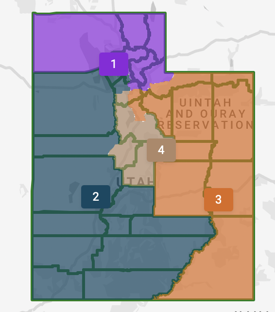
This map was controversial since it split Democratic-leaning Salt Lake County — which contains about one-third of Utah's population — four separate ways, dividing up the Salt Lake-area votes in a way that one district stretches all the way to Washington County.
The map that ended up passing the house was the one created by the committee chairs, Rep. Paul Ray, R-Clearfield, and Sen. Scott Sandall, R-Tremonton, the two chairs of a Legislative Redistricting Committee appointed to draw up new maps, by a vote of 50-22.
The committee chairs released their maps late on Friday night, giving the public very little time to comment on them. But in the maps produced and presented at a contentious redistricting hearing on Monday, both chairs defended their own maps, saying they believed in an urban-rural mix for congressional districts.
“We've made decisions that we think best reflect the will of the people that we are elected to represent,” Ray said at the redistricting hearing on Monday.
“We are one Utah and we are in one combined community of interest, in my view,” said Sandall, the co-chair of the Legislative Committee.
Ultimately, the Legislature approved all the committee chair maps for redistricting, although not without controversy. Hundreds of residents showed up and complained these maps were gerrymandered, including Evan McMullin, a former presidential candidate and a current challenger to incumbent U.S. Sen. Mike Lee, and Katie Wright, the executive director of Better Boundaries Utah.
Democratic state senators called the congressional map passed by the Legislature an "unacceptable abuse of power"
Representation must be close to and created by and for the people. The Legislature’s passage of H.B. 2004 blatantly silences the voices of Utahns through Congressional boundaries that unacceptably divide and crack our communities #Utpol #Utleg pic.twitter.com/eMMCZbWwd5
— Utah Senate Democrats (@UtahSenDems) November 10, 2021
There were alternative maps proposed by the Independent Commission that was backed by Democratic representatives, but those maps failed.
These donut hole maps would have created two urban districts along the Wasatch Front and two large rural districts encompassing both the northern and southern parts of the state. They failed, 55-17.
Some Republicans voted against the majority on these congressional maps, including Rep. Ray Ward, R-Bountiful, who created his own map, saying it would be more competitive and create a swing district.
"There need to be places where people know it could go either way," Ward said about why he supported the idea.
Ultimately, Ward's map failed to get adopted.
House Speaker Brad Wilson, a Salt Lake City Republican, was steadfast in his preference for elected legislators to have the power to draw voting districts over appointed independent commissioners, saying the Utah Constitution gives the Legislature the final say on redistricting.
The majority of state senators agreed, approving the congressional map with a veto-proof majority. All six Democratic Senators voted against this map, along with one Republican, Sen. Daniel Thatcher of West Valley.
Southwest Utah would remain under a similar district as it is today, inside of District 2, which stretches from Salt Lake City to St. George and is currently represented by U.S. Rep. Chris Stewart, a Republican. Some local leaders argued during the redistricting process that incumbency should have an influence in how the maps are drawn.
"If we can put in a plug for Washington County … we firmly want Congressman Stewart since they already understand the issues,” said Adam Snow, a recently-appointed Washington County commissioner who previously worked as a staffer for Stewart, during a redistricting hearing in September.
St. George Mayor Michele Randall said that even with the city growing fast, she prefers an urban-rural mix of congressional districts and likes Stewart.
"We still have many rural land issues throughout our county that only Congressman Stewart is very familiar with and well versed," Randall wrote in an email to the Independent Commission and shared with The Spectrum.
State House Districts
Due to Washington County's explosive growth since 2010 — the population increased by more than 30% — the area is getting more representation in the statehouse.
"Understand, the biggest population shifts happened in Utah County, and down in southern Utah and Washington counties,” Ray said during the Monday redistricting hearing.
Each House district would ideally represent roughly 43,000 residents.
That means that under the new map Washington County will have four representatives exclusively inside the county lines, up from three in the current maps.
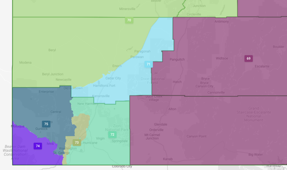
A district that currently includes part of Iron County would now stop at the eastern and northern borders of the county and cover the Hurricane Valley area and Zion National Park.
Iron County is mostly represented under two districts under the new map, with the 71st district exclusive to Iron County. The 70th district will be combined with Beaver, Sevier and Piute counties.
These maps were approved quickly by lawmakers, with debate on the house floor over the statehouse map lasting around 20 minutes. They were approved by a vote of 60-12 by the house and by 25-3 in the senate.
Although Democrats did introduce motions that would've adopted maps produced by the Independent Commission during the debate, all these motions were voted down by the majority.
Senate Districts
The senate maps also sailed through the Legislature with relative ease on Wednesday, passing the House by a vote of 60-12 and the Senate by a vote of 26-2.
Sandall said this map tried to keep the "core" of current districts intact as much as possible since the Senate currently has an average term of fewer than seven years. Voters are responsive to senators and will elect new senators if they wanted to, he said, remarking that "the will of the voters have spoken" when it comes to senate terms.
He also argued that it would be a disservice to drastically change the makeup of senate districts where it wasn't called for, since senators have gotten to know their districts well and the people they represent.
The senate districts were renumbered for the ease of the Legislative staff, said Sandall, meaning the senate district numbers look different than the original map that was shown on the night of Nov. 5.
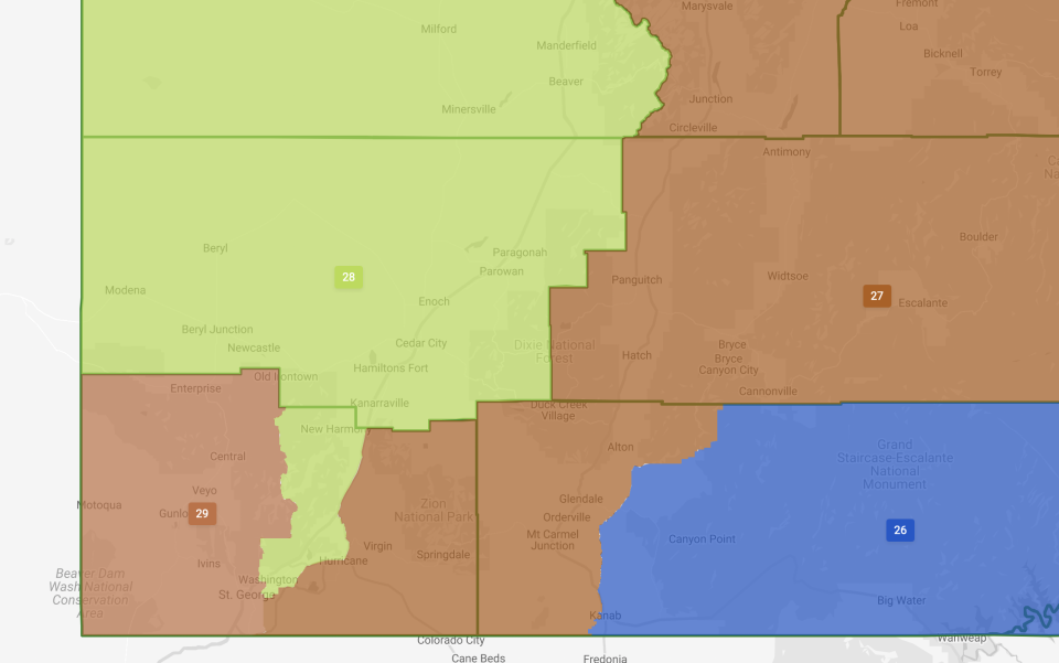
But this new district map does significantly change the makeup of senate districts in southwest Utah. Before this corner of the state only had two senators. Now it will have three senators, meaning three state senators could technically live in Washington County in the future. But two of the three districts will be very large geographically and encompass multiple counties.
Each district is supposed to have an ideal size of roughly 112,000 residents.
The 27th district will be one of the largest land-size districts in the state and will cover portions of 10 counties, combining the eastern part of Washington County with several central counties including Utah County.
The 28th district will now just take a sliver of central Washington County including Washington City — which is the county's second-most-populous city — after this district covered the eastern part of the county for the last 10 years. That sliver of Washington County will be combined with all of Iron County and three other counties going north along Utah's border with Nevada.
The 29th senate district will be the only one that is exclusive to Washington County and is currently represented by Sen. Don Ipson. This district looks very similar to the previous senate district in that it covers St. George and the western part of the county.
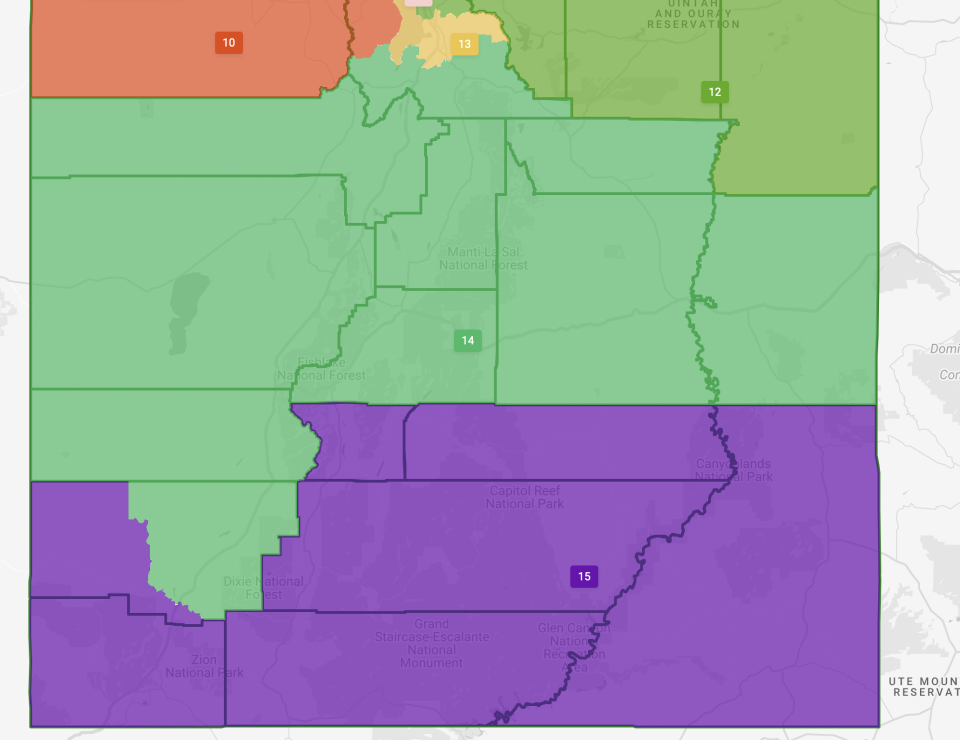
School Board Maps
The state school maps weren't debated much on either floor and passed the house by a vote of 59-11 with much of the attention on this map given to how districts were divided within Salt Lake and Davis County.
For southern Utah, the 15th district is now much larger geographically. Previously this district was just Iron and Washington counties. Now, this district only takes a part of Iron County and combines it with Washington County and five other southern Utah counties that go across the entirety of the state.
In this new map, St. George and Cedar City will be in two different school board districts, with St. George in the 15th and Cedar City is in the 14th. Cedar City and a large chunk of Iron County will be combined with nine counties that cover the mostly rural central part of the state. It also combines Cedar City with the southern portion of the state's second-most-populated county, Utah County.
These maps need the approval of Gov. Cox, which is likely to happen since Cox said during the virtual town hall event he isn't a "bomb thrower" and will honor the maps passed by the Legislature.
Sean Hemmersmeier covers local government, growth and development in Southwestern Utah. Follow on twitter @seanhemmers34. Our work depends on subscribers so if you want more coverage on these issues you can subscribe here: http://www.thespectrum.com/subscribe.
This article originally appeared on St. George Spectrum & Daily News: Washington, Iron counties to get more representation under new maps
