Water levels on the Mississippi River are plummeting for the second year in a row
Water levels along the Mississippi River are plummeting for the second year in a row after this summer’s blistering heat and low rainfall triggered extreme drought across parts of the Central US.
The low water levels have made a unique rock formation in the Mississippi River, usually surrounded by water, accessible by foot, and the Army Corps of Engineers is increasing the size of a levee in Louisiana to prevent saltwater from surging into drinking water in New Orleans.
The drought comes as a critical harvest season approaches and farmers across the Midwest are concerned about water supply and barge deliveries. Officials and residents along the river worry about the widespread impacts another decline could bring.
Every water level gauge along a nearly 400-mile stretch of the Mississippi from the Ohio River to Jackson, Mississippi, is at or below the low-water threshold, according data from the National Oceanic and Atmospheric Administration and US Geological Survey.
The same stretch of the river experienced record-low water levels last year in October, which brought major impacts on farming communities and barge traffic during the critical harvest period, where staple Midwestern crops including soybeans, corn and wheat are transported down the river.
“We’ve been teetering on drought, extreme drought since last fall,” said Colin Wellenkamp, the executive director of the Mississippi River Cities and Towns Initiative, a network that includes mayors and experts along the Mississippi River.
“We get a little reprieve, and then it’s warm and dry,” Wellenkamp told CNN. “We really haven’t ever totally climbed out of the drought from last fall for the whole river yet.”
Exceptional drought – the worst category – has spread across parts of Texas, Louisiana and Mississippi. This year has so far been the hottest on record for Louisiana and Mississippi, according to recent figures from NOAA dating through August.
Extreme drought is present in several states across the Midwest, including Minnesota, Wisconsin, Iowa and Missouri, according to the US Drought Monitor.
“Those four states have really been significantly impacted by drought since last winter, it’s just ongoing,” Wellenkamp said.
Tower Rock accessible again – with a catch
A rock formation in the Mississippi River normally only reachable by boat is accessible by foot for the second year in a row due to the drought and low water levels, gauge data shows and officials with the Missouri Department of Conservation told CNN, but work on a pipeline is impeding road access to the formation.
Tower Rock juts out of the Mississippi River in Perry County, south of St. Louis and around 25 miles north of Cape Girardeau. When water levels drop below 1.5 feet at a nearby river gauge, enough of the underlying ground is exposed for people to walk to the formation.
Water levels at the gauge were near zero as of September 20, with no improvement forecast in the near term.
This rare occurrence happened last October amid another severe drought, causing tourists to flock to the site.
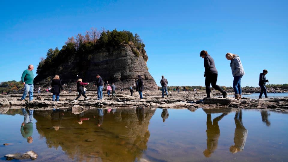
“Previous to last year, it was probably only accessible once or twice in the last decade,” Steve Schell, a natural history biologist at the Missouri Department of Conservation, told CNN.
Unfortunately for potential tourists, road access to the site is impeded by construction work on a pipeline, officials with the Missouri Department of Conservation told CNN. They urged people to schedule a visit at a later date, but said they were unaware when the work would be completed.
None of the officials CNN spoke to had been to the site since it became accessible by foot, both because of the lack of road access and because of low water levels which made it hard to access by boat.
“Part of the consequences of low water, is there are not a lot of places you can put a boat in on the river anymore,” Schell said. “All of those places are dry, and the only place they have right now is south of Cape Girardeau. Tower rock is, off the top of my head, 20 or 30 miles from the only available boat ramp.
Salty ocean water threatens drinking water
As water levels drop, the threat of saltwater intrusion is growing in Louisiana as ocean water pushes north into drinking water systems, unimpeded by the Mississippi’s normally mighty flow rate.
Gov. John Bel Edwards declared a state of emergency for Plaquemines Parish in July as saltwater began to impact drinking water systems there, and the US Army Corps of Engineers built a 1,500-foot-wide underwater levee south of New Orleans to prevent it from pushing even farther north.
Last week, Plaquemines Parish President W. Keith Hinkley said at a news conference that clean water was being distributed to around 2,000 residents who were impacted by the saltwater intrusion. The Army Corps also announced plans at the same news conference to make the levee larger.
“Based off the current forecast, and if no action is taken, you could potentially see the saltwater wedge all the way up to the French Quarter,” Cullen Jones, commander of the Army Corps’ New Orleans District office, said at a news conference on Friday.
But as the Army Corps is building up the riverbed in Louisiana, it has been dredging other portions of the river to keep traffic flowing – albeit at a slower pace than normal. The treacherously low river has been impeding hundreds of barges and vessels from passing through — and it is also causing the cost of transporting some of the harvest to soar.
“They have to light load barges in order to get them to float, so it’s more trips,” Wellenkamp said. “And so you’re not putting as much product into one barge. The barge will move on, and it’s gotta go back again — all of this eats up a lot of fuel and eats up a lot of time.”
There are also signs that drought and low water levels get worse in the Upper Midwest as El Nino strengthens in the Pacific Ocean, said Jonathan T. Overpeck, dean of the school for environment and sustainability at the University of Michigan. But this year’s conditions were not caused by the natural climate phenomenon, he said.
“This is heat that has already been trapped in the system due to climate change,” Overpeck told CNN.
Unless officials invest in efficient climate adaptation projects to protect communities, he said, it will be an increasingly challenging problem as the planet warms.
“These conditions will only become more frequent, if we don’t phase out fossil fuels,” Overpeck said. “It’s cooking the planet and we’re seeing the impacts unfold in the Mississippi River right now.”
For more CNN news and newsletters create an account at CNN.com

