Central Florida is waking up to breezy conditions after Saturday’s rain maker
Read weather updates below:
▶ WATCH CHANNEL 9 EYEWITNESS NEWS
▶ DOWNLOAD OUR WEATHER APP
12:25 a.m. update:
The rain will continue overnight as well as the risk of more minor street flooding. But that will taper off by Sunday morning.
There is still an outside chance of a strong storm, but the chance of severe weather continually decreased Saturday evening, certified meteorologist George Waldenberger said.
Read: Powerball: Jackpot climbs to $543 million
He said cooler temperatures have minimized the chance of storms organizing.
There is still an outside chance one or two strong storms could form, so Waldenberger will continue to monitor conditions overnight.
By Sunday morning, rain will taper off and winds will shift, he said.
It will feel cooler by Sunday afternoon as a post-storm chilly blast begins.
Download the WFTV weather app to stay informed of weather conditions in your neighborhood.
10:45 p.m. update:
A strong system will pass over Florida overnight through Sunday morning.
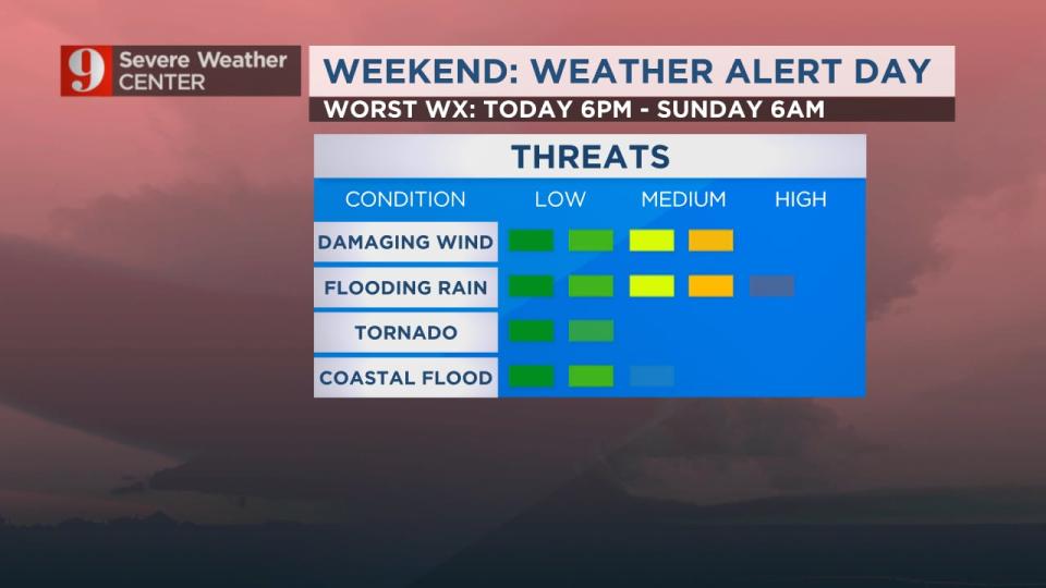
There is a risk of isolated severe, wind-producing storms late Saturday and early Sunday as the system makes its closest approach to Central Florida.
Rain will taper off by morning, but windy and cooler weather moves in tomorrow.
Read: Volusia County officials prepare for strong storms at the beach overnight
Rain has already topped 4 inches in some areas and wind gusts have topped 50 mph in some coastal areas.
More than six inches of rainfall is possible before the region dries out Sunday.
Read: Sheriff: WWE wrestler Liv Morgan arrested in Sumter County
Certified meteorologist George Waldenberger said he is keeping an eye out for more flood advisories.
He said an isolated risk for tornadoes or storms with damaging winds remains possible for Central Florida as the system passes through.
Watch live updates on Channel 9 Eyewitness News, and download the WFTV weather app to be notified about severe weather in your neighborhood.
Read: Woman killed in hit-and-run crash in Titusville, police say
7:30 p.m. update:
A flood advisory will continue for parts of Orange and Seminole counties.
These include Orlando, Apopka, Altamonte Springs, Oviedo, Winter Springs, Winter Park, Casselberry, Maitland, Longwood, Goldenrod, College Park, Azalea Park, Lockhart, Pine Hills, University Of Central Florida, Fern Park, Orlando Executive Airport, Fairview Shores, Union Park and Forest City.
The advisory is until 9:45 p.m. Saturday.
More flood advisories are popping up around Orlando, Kissimmee, St. Cloud, Brevard County...some local areas are approaching 4" for rainfall and it continues into the night, with a few storms potentially developing. pic.twitter.com/E9soPnZUBR
— George Waldenberger (@GWaldenWFTV) December 17, 2023
5:30 p.m. update:
The National Weather Service has issued a flood advisory for a portion of east Central Florida, including Brevard, Orange, Osceola, Seminole and Volusia County.
This means minor street flooding is possible and could impact areas that are low-lying and have poor drainage.
The advisory will be in effect until 7:15 p.m.
Officials advise you to be cautious when driving at night and not to drive on flooded roads.
Here is a list of the affected locations:
Orange County: Avalon Park, Azalea Park, Bithlo, Christmas, Chuluota, Conway, University Of Central Florida, Goldenrod, Orlando, Wedgefield, Winter Park
Seminole County: Casselberry, Goldenrod, Oviedo, Winter Springs
Brevard County: Cocoa, Lone Cabbage Fish Camp, Port Saint John, Sharpes, Titusville, Titusville Airport
You watching the Cure Bowl on Channel 9? Very wet game! Flood advisory extended into Orange County, including area around FBC Mortgage Station where the game is being played. Minor flooding possible, 2"+ have fallen in spots. pic.twitter.com/5yX68D5IRP
— George Waldenberger (@GWaldenWFTV) December 16, 2023
Previous story:
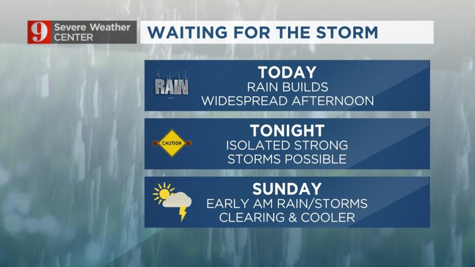
First the rain, then the storms.
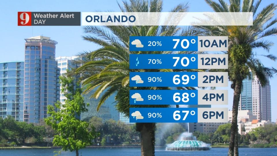
Rain has been widespread today, but that is not why the Weather Alert Day was issued for the weekend.
Meteorologist George Waldenberger said it’s because strong storms are possible tonight as the center of the storm system gets closer and then passes Florida.
First advisory...possible minor street flooding as Brevard County has picked up 2"+ rain in spots. Expecting rain to pick up tonight. pic.twitter.com/ZErlAOEh9a
— George Waldenberger (@GWaldenWFTV) December 16, 2023
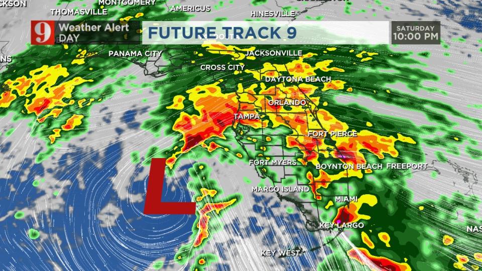
The current track of low pressures schedules it to pass just to the north of Central Florida overnight through Sunday morning.
Read: Events around Orlando making changes or canceling for this weekend
That puts Central Florida under a risk of isolated strong to severe storms, which could include damaging winds, or even a tornado warning tonight and overnight.
Severe weather won’t happen everywhere, but be ready if you get a storm warning overnight. Severe Weather Center 9 will be monitoring the storm.
Also, note that 2-4 inches of rain are likely with isolated higher amounts.
Surf is rough at the beaches, and the winds will get stronger as the storm passes.
Any rain will end early Sunday morning, and it’ll stay gusty and get cooler by the end of the day.


Follow our Severe Weather team on X for live updates:
Click here to download our free news, weather and smart TV apps. And click here to stream Channel 9 Eyewitness News live.

