Broward public schools shut down Thursday as heavy rains hammer South Florida into the night
South Floridians are getting drenched Wednesday night as torrential downpours inundate the region — and forecasters predict the worst showers lie ahead. The inclement weather prompted officials to shut down all Broward County public schools on Thursday.
Bracing for more rain and potential flooding, the Broward County Public School district announced class cancellations, which include any extracurricular activities before and after-school.
“To ensure the safety of students and staff, all District schools and administrative offices will be closed on Thursday, November 16, 2023,” the district said. “BCPS thanks all its employees, especially our maintenance and facilities personnel, who will be canvassing schools to assess if any campuses experience water intrusions or other damages.”
Broward College had already canceled classes Wednesday. It’s unclear whether they, too, will close operations tomorrow.
As for Miami-Dade County Public Schools, the district wrote on X that it will monitor the weather situation overnight but plans to remain open Thursday.
.@MDCPS continues to monitor local weather conditions. All Miami-Dade County Public Schools remain OPEN tomorrow, November 16, 2023. pic.twitter.com/fHQUQ22SCb
— Miami-Dade Schools (@MDCPS) November 16, 2023
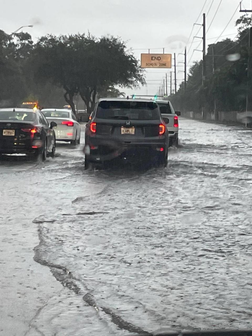
As downpours intensify, Fort Lauderdale is seeing flooded roadways and stalled cars, similar to what the area experienced Tuesday night. Dozens of crashes have been reported in Broward through the day on slick roads and highways with ponding water.
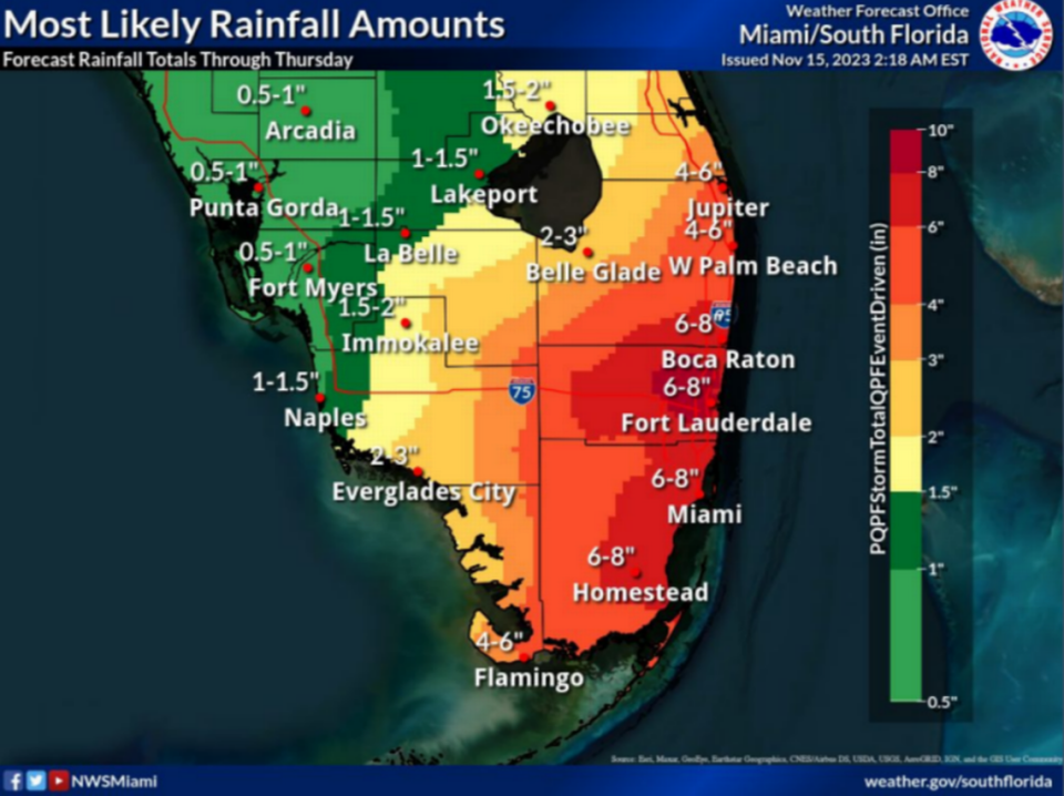
The region could see up to 10 inches of rain by night’s end, forecasters say.
Wednesday’s rains are linked to a low pressure system that could cause flooding in South Florida through Thursday mid-morning, the National Weather Service in Miami said Wednesday afternoon. It’s also triggered several advisories.

A flash flood warning was issued Wednesday night for a small portion of Miami-Dade, but was later changed to cover almost the entirety of the county. It will last until 6 a.m.
Another flash flood warning was also issued for nearly the entirety of Broward until 6 a.m.
The system’s rain bands coming from the Gulf of Mexico are forecast to bring 4 to 6 inches of rain in Miami, Fort Lauderdale, Palm Beach and Boca Raton. About an inch had already fallen during the morning and early afternoon, but no major flooding had been reported in the area early Wednesday, weather service meteorologist Ana Torres-Vazquez told Miami Herald.
On Tuesday night, storms followed by major street flooding stalled cars in Broward.
“The worst hasn’t come yet,” Torres-Vazquez said.
What else should South Floridian’s expect? Here’s the latest update:
When is the heaviest rainfall expected?
The heaviest rainfall is expected Wednesday afternoon through Thursday morning, the National Weather Service said.
“Shower activity continues to increase across South Florida early this afternoon with the greatest concern for flooding occurring later this afternoon into the evening hours,” the weather agency said on X, formerly Twitter.
READ MORE: Disturbance to affect South Florida and the Keys while another threatens the Caribbean

Where will it rain the most?
There’s uncertainty on exact totals and timing of the heaviest rainfall, the weather agency said, but it’s expected to rain the most in the east coast metro areas.
The approximate times for high tide in metro South Florida are 10 p.m. Wednesday and 11 a.m. Thursday, meteorologist John Morales said on X.

“The ability for rain runoff to drain out to sea and/or be stored underground will be diminished in the hour leading up to those times, hastening floods,” Morales added.
Approximate times for high tide in metro South Florida: 10 AM, 10 PM, and 11 AM tomorrow. The ability for rain runoff to drain out to sea and/or be stored underground will be diminished in the hour leading up to those times, hastening floods. A Flood Watch continues in effect https://t.co/tX6yH6kt7d
— John Morales (@JohnMoralesTV) November 15, 2023
How much rain is forecast?
Forecast rainfall amounts in some areas could reach 10 inches in a worst-case scenario, Torres-Vazquez said.
“There is a one in 10 chance that will happen,” Torres-Vazquez said.
The weather agency said on X: “Very heavy rainfall could lead to highly impactful urban flash flooding.”
Be sure to remain weather aware across South Florida today and tonight. Very heavy rainfall could lead to highly impactful urban flash flooding.
A Moderate Risk (level 3/4) of Excessive Rainfall is in effect. #FLwx pic.twitter.com/LiFlu6Oe95— NWS Weather Prediction Center (@NWSWPC) November 15, 2023

Are there any flood watches or warnings?
A flood watch remains in effect for the coastal and metro areas of Palm Beach, Broward, and Miami-Dade counties through Thursday morning, until around 10 a.m. A flood watch is also in effect for the Florida Keys during the same time period.
“Those living in areas prone to flooding should be prepared to take action should flooding develop,” the National Weather Service in Key West said Wednesday.
Here are the most likely rainfall amounts, and the worst case (1 in 10 chance) rainfall amounts through Thursday morning. Confidence is higher on heavier rainfall totals along the entire Southeast Florida coast. (2/3) pic.twitter.com/OCbhA2aU0B
— NWS Miami (@NWSMiami) November 15, 2023
What else do you need to know about the weather?
A wind advisory is in effect for all coastal Atlantic areas for easterly winds 20 to 30 mph with possible gusts up to 40 mph until 1 p.m. Thursday. A small craft advisory was in effect for Biscayne Bay until 4 p.m. Wednesday. And a gale warning remains in effect though 4 p.m. Thursday from Jupiter Inlet to Deerfield Beach. A small craft advisory was also in effect for the coastal waters of the Florida Keys on Wednesday afternoon
Additionally, a Coastal Flood Statement is in effect for all of the #FLKeys and a Small Craft Advisory is in effect for the coastal waters.
Be sure to visit https://t.co/I7EVypI26l for the latest! (2/2)#FLwx #FloridaKeys #KeyWest #MarathonFL #KeyLargo pic.twitter.com/oHGe62w4wT— NWS Key West (@NWSKeyWest) November 15, 2023
Heavy rainfall is ongoing and expected to increase/worsen across southern FL this afternoon and evening with significant flash flooding possible. #TurnAroundDontDrown pic.twitter.com/kHHZkkPwAs
— National Weather Service (@NWS) November 15, 2023

