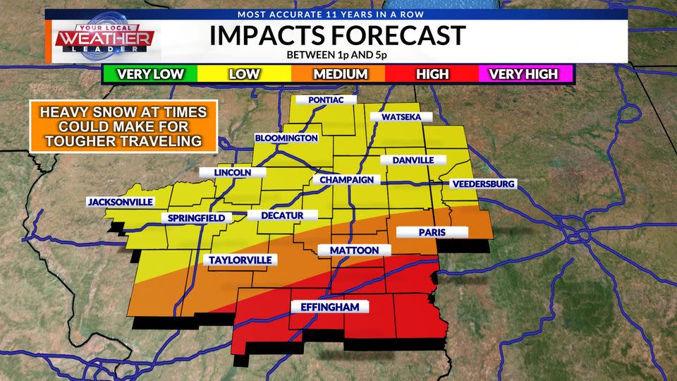
WEATHER BLOG: Friday Snow 2/16/24


Winter Weather Center: Live Traffic Updates
Weather Map Room: Live Current Conditions
Friday 9:00
Our attention now is on the rapid fall of our temperatures as skies clear tonight. Lows will find their way into the low teens and upper single digits, with wind chill values near 0. With things becoming so cold so quickly, we will see a lot of our precip at the ground refreeze and compact together, making things slippery once again. Be careful if you are driving late tonight or early tomorrow morning.


Friday 6:20
Here is a video and audio recording of the thundersnow heard earlier today in Effingham County! As you can hear, this was a loud boom that a lot of people throughout the county managed to hear! Video submitted by Jessica Fritch in Mason, IL
FRIDAY 5:23
As of 5:23 PM Friday, here are some of our highest official snowfall amounts. We should see some more reports trickle in later tonight as those around I-70 are just now wrapping up the snow, but as you can see, lots of places saw over 3″ today! The big winner of the day was Sangamon County, as multiple towns got 6″ or more!

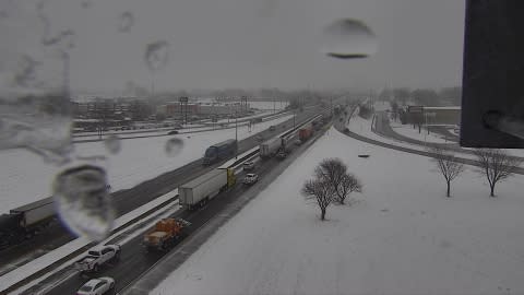
FRIDAY 4:28
Snow is almost entirely out of the area, and as it exits, road conditions should begin to improve for a brief window of time as the warm ground will help melt away the snow. Later tonight however, temperatures are set to enter the teens and single digits, which will cause that leftover precip to freeze in some spots.

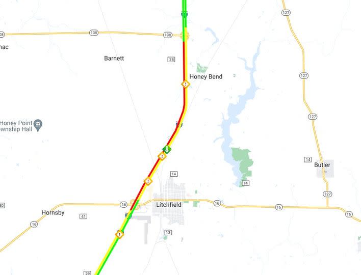
FRIDAY 3:45
Numerous crashes reported on I-55 near Litchfield this afternoon. Avoid the area.
FRIDAY 3:15
3:15p – Accident reported on I-74 EB past the Neil street exit, has traffic backed up a bit.
Other accident reports are coming in quickly in parts of the I-70 corridor and on I-57 from Mattoon Charleston south to Effingham, and especially heading south toward Mount Vernon.
More reports of crashes are coming in from the Edgewood area on I-57 south of Effingham.

FRIDAY 2:35p
Thundersnow has been reported in the Effingham County area. A strike of lightning and a large rumble of thunder was reported in the heavy snow just before 2:30p near Mason. The thunder was heard across the area.

Did you hear it? Do you have a video doorbell that might have caught the thunder? Check at around 2:28p to see. Our weather team would love to hear your reports and see any footage you’d be willing to pass along.
Thundersnow is a thunderstorm that occurs, but instead of rain, there is snow (often heavy) falling. For this to happen, typically there has to be vertical motion in the atmosphere similar to what you would see in summertime thunderstorms. As warm air is forced upward from cold air moving in at the surface, it allows for enhanced rising motion which allows for conditions that are conducive for thunder and lightning during heavy snow. In addition, the heavy snowfall tends to muffle the sound of thunder so it is more like a low rumble compared to a sharp clap of thunder you might experience in a summer thunderstorm. You can also have thundersleet in similar conditions like what we are experiencing today.
FRIDAY 2:15p
Last real thumping band pushing through Champaign-Urbana, Decatur and into Taylorville now. It’ll continue sliding to the east and then snowfall begins to diminish. Might be a few minutes of VERY heavy snow with it.

FRIDAY 1:50p
New information from ISP indicates that two accidents occurred on I-74 between Urbana and St. Joseph this morning, one of them involving an IDOT Plow Truck. The incidents resulted in I-74 becoming closed for a period of time.
An email response from ISP to an inquiry about the scene: “Preliminary information looks like there were two separate crashes on I-74 westbound around 8:20 AM. Troopers initially responded to a single vehicle property damage crash. There were no injuries with it. Once on scene they also located a Jeep that had struck an IDOT snow plow. The driver of the Jeep was transported to a local hospital with injuries while the plow driver was uninjured.”
Read more on the story below as it becomes available.
FRIDAY 1:40p
IDOT reports several crashes/slide-offs along I-70 from Vandalia to Effingham to Cumberland County that have resulted in various lane closures in the area. Roads are slick in the area.
Latest reports from IDOT on road conditions in the area.

FRIDAY 1:30p
THUNDERSNOW: There’s been reports of thundersnow with lightning strikes across parts of Missouri and Illinois, including even in the St. Louis area in the last hour. An occasional clap of thunder can’t be ruled out even as far north as the I-70 corridor through this evening.
Thundersnow occurs when intense rising motion generates convection similar to that in the warm season, but instead of rain it’s cold enough for sleet and snow.

FRIDAY 1:20p
Road conditions really beginning to worsen in Effingham and along the I-70 corridor as the heaviest snow band moves in.

FRIDAY 12:30p
Thinking based on trends, we’re fixing to have some problems this afternoon along the I-70 corridor. The snow band in St. Louis is causing lots of traffic problems. Be aware and slow down in heavy snow. Roads can quickly become slick.
FRIDAY 12:20p
Here’s the latest from WCIA 3 News at 12p on the snow in the area.
FRIDAY 12:00p
The next band of heavy snow is heading for areas that have missed out on the sticking snow.

FRIDAY 11:50a
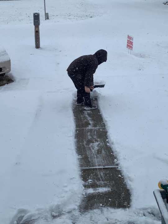
Here’s some viewer photos from around the area of the snow.


FRIDAY 11:35a
Take advantage of this delicious recipe from Meteorologist Jacob Dickey if you haven’t ever made it!

FRIDAY 11:00a
Quick update from Jacob.
FRIDAY 10:15a
We’ve had some improvement in road conditions in the last hour or two in Champaign-Urbana. You can see where roads have been treated compared to parking lots that have not.

As the snowfall rates decrease and the initial thumping snow band exits, snow melting rates can overcome the snow falling and therefore with a net deficit, snow melts on roads. There is still slush but it’s a lot better than an hour ago.
However, even with just wet roads, with plummeting temps tonight, black ice and slick spots remain a concern.
Latest road conditions below:

FRIDAY 10:15a
Notice from Danville MTD:
Due to bad road conditions on Interstate 74, the 10:20 Danville-Champaign is being cancelled. We will reevaluate the road conditions and make a decision on the 12:20 Danville-Champaign. Sorry for any inconvenience this may cause.
Steven White
Director of Public Transportation
Danville Mass Transit
Decatur Public Transportation System is also running snow routes only for buses today. A message from them:
We are operating on snow routes only to start the day – Friday, Feb. 16, 2024
Due to weather conditions, we will have buses operate on snow routes until further notice. Thank you and travel safe!
ISP Troop 6 reports they have handled 3 motorist assists and 11 crashes. No further information is available on the severity of any of the crashes as crews continue to respond in the area.
FRIDAY 9:15a
The City of Rantoul has activated snow routes immediately.
“Snow routes will go into effect starting immediately through Saturday morning at 6:00AM. Please be sure all vehicles on an emergency snow route are moved as soon as possible.
During a snowfall where an accumulation of two or more inches occur, vehicles may not park or remain parked on designated streets.”

Report from DeWitt County Sheriff’s Office: Current road condition US Route 51 approximately 1 mile North of IL Route 10. Southbound lanes partially blocked due to minor semi tractor / pick up truck accident (property damage only). Use caution in this area. All roads are hazardous use caution while traveling.

Champaign County Sheriff’s Office reports the following: “We have already received a few reports of slick roads and slide offs this morning since the snow started. Please use caution when traveling today: make sure your headlights are on, leave early, and drive slow.”
Cass County Sheriff Devron Ohrn reports slick roads in the area. “There is enough snow to make things interesting and it’s wet and slick. Use caution as the slushy snow is hard to navigate. Temp is 29 so I assume less traveled roads will stay a little sketchy for a bit.”

FRIDAY 8:55a
Multiple crashes and slide-offs reported in Champaign County from ISP, IDOT and viewers. Road conditions are deteriorating quickly.
Facebook Live from 8:30a from Jacob.
FRIDAY 8:10a
IDOT reports a slide-off/crash on I-74 EB near Lake of the Woods. Slow down when you see snow falling, roads can become slick very quickly.

FRIDAY 7:55a
IDOT reports a crash on I-55 NB at the Chatham exit with lanes closed. Traffic is backed up in the area. We are working to get more information from Illinois State Police.

FRIDAY 7:50a
If you were up early this morning and noticed no snow falling, but you saw your radar on the app showing snow, it is because of dry air at the surface that was eating away at light snow trying to fall.

Once the heavier band arrives and snowfall rates increased quickly, that dry air no longer becomes a problem and you’ll go from no snow to heavy snow in a very short period of time.
The high rate of snowfall also is enough to overcome the warm ground. Widespread 2″ appears likely with a few of us making a run at 4″ somewhere locally.

FRIDAY 7:30a
Many of you have shared photos of the snow in the area this morning, particularly along I-55. Snow will continue to fill in from west to east during the morning and at times may fall at a heavy rate.


FRIDAY 7:10a
Slick roads are being reported across parts of Central Illinois this morning. Get the latest on the WCIA 3 Winter Weather Center.
FRIDAY 6:35a
Here’s a look at snow-covered roads in Jacksonville this morning.

FRIDAY 6:30a
Snow begins to pick up over the next few hours. The worst conditions will be mid to late morning into the early afternoon. By tonight, wet roads could freeze up with temperatures plummeting into the teens, especially on surfaces that aren’t treated.

Download our WCIA 3 Weather App to stay up-to-date through the day, and be sure to also get the WCIA 3 News app while you’re at it!
WEATHER NOW FORECAST: Snow is back for Friday

For the latest news, weather, sports, and streaming video, head to WCIA.com.

