Weather: Clear, cool here as focus is on Hurricane Ian path and power
As Hurricane Ian intensifies, Greater Cincinnati will continue to experience relatively dry and sunny days.
According to the National Weather Service, there will be a gradual cooling trend into the middle of the week. A few showers will be possible from west central into central Ohio.
Entertainment:These epic fall hikes are within driving distance of Ohio
Expect mostly sunny days with highs in the low 70s to high 60s throughout the week.
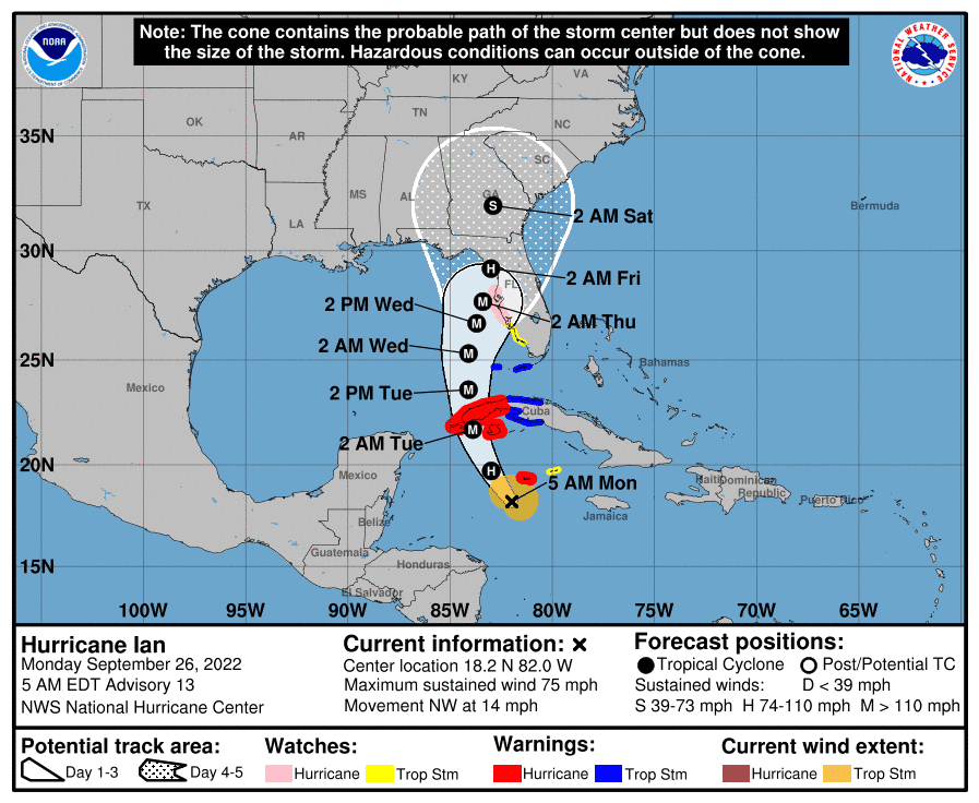
The focus heading into the weekend will be the fate of Ian. There is still a lot of uncertainty in the paths and speed of movement of the system, according to the weather service. The effects for the region range from some showers to rain drenching the entire area.
A gradual warming trend will occur starting Friday, with temperatures reaching the mid-70s by Sunday.
Detailed Cincinnati Forecast
Monday: Sunny, with a high near 70. Tonight, partly cloudy, with a low around 47.
Tuesday: Sunny, with a high near 67. Tuesday night, mostly clear, with a low around 45.
Wednesday: Mostly sunny, with a high near 65. Wednesday night, partly cloudy, with a low around 45.
There will be a gradual cooling trend into the middle of the week. A few showers will be possible from time to time from west central into central Ohio. pic.twitter.com/SBIvb5iYw1
— NWS Wilmington OH (@NWSILN) September 26, 2022
Thursday: Mostly sunny, with a high near 67.
Friday: Sunny, with a high near 71.
Saturday: A chance of showers. Partly sunny, with a high near 71. Chance of precipitation is 30%.
Sunday: Partly sunny, with a high near 74.
Source: National Weather Service, Wilmington.
Fall 2022:When does daylight saving time end in 2022? Here's when we 'fall back' and gain sleep
This article originally appeared on Cincinnati Enquirer: Hurricane Ian: What will storm mean for weather here?

