Only a half-inch to an inch of snow is forecast. But winds gusting to 50 mph could potentially create a whiteout known as a snow squall

The weather across much of Wisconsin is forecast to turn nasty — in brief, sudden bursts — beginning late Friday afternoon, forecasters say.
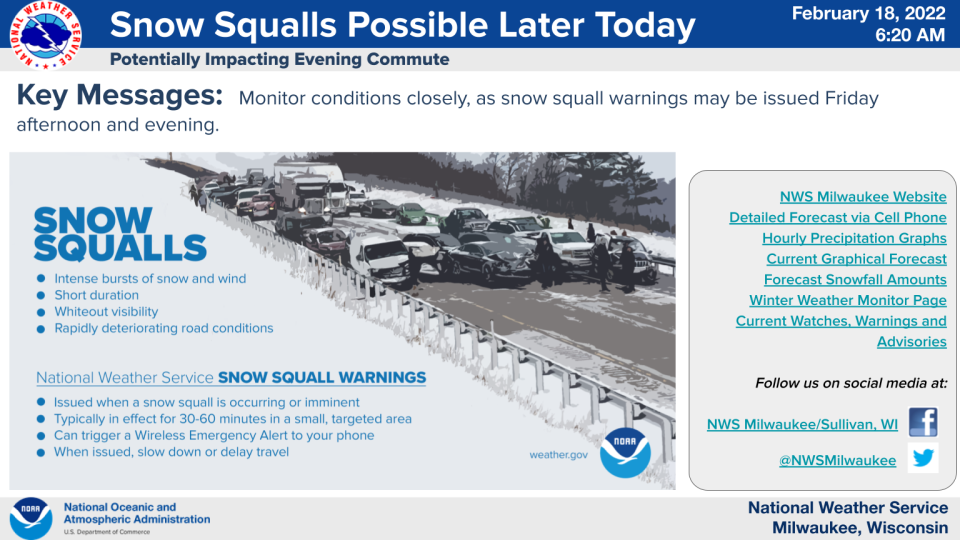
The National Weather Service is warning of the possibility of snow squalls — quick bursts of brief, heavy, wind-driven snow that can send visibility down to almost zero and make driving a nightmare.
A sudden burst of heavy snow in April caused a 100-vehicle pileup on I-41 in Washington County.
Here's how things are shaping up for Friday, according to the weather service:
Strong southwest winds up to 50 mph are expected during the afternoon. Those winds will reverse direction and begin blowing out of the northwest on Friday evening as an arctic cold front sweeps the state.
Out ahead of the front, snow showers -- some of them briefly moderate to heavy -- are expected to occur.
"Winds are going to pick up immediately before and after the snow that moves along the front," said Cameron Miller, a meteorologist with the weather service in Sullivan.
Only a half-inch to an inch of snow is expected in southern Wisconsin, but it may fall all at once in what's known as a snow squall.
"It’s going to be a very quick shot of snow," Miller said.
In an updated forecast statement issued Friday afternoon, the weather service office in Sullivan said, "Conditions still remain favorable for potential snow squalls this afternoon as gusty winds ramp up and snow showers develop along an arctic cold front currently positioned to our northwest."

Snow squalls are usually very short — they might last 30 to 60 minutes — but they are "extremely intense" bursts of snow, according to the weather service.
"There will be a pretty widespread band of snow along the front," but exactly where and if snow squalls set up remains to be seen, Miller said.
"In those localized, intense areas, you are going to see higher snowfall rates that could cause whiteout conditions and quick accumulations on roads," Miller added.
Meanwhile, on Friday, winds could gust to 50 mph during the afternoon and into the overnight hours.
A wind advisory is in effect from 2 p.m. Friday until 4 a.m. on Saturday.
Milwaukee weather radar
Refresh your browser if the radar isn’t working or click here if you can’t see it.

Snow squall warnings are fairly new
Don't be surprised if your mobile phone starts buzzing with snow squall warnings on Friday.
Numerous snow squall warnings were in effect across south central Wisconsin on Friday evening.
The weather service decided to begin issuing snow squall warnings because of, among other things, the number of big freeway pileups and crashes in the U.S. that have occurred with snow squalls.
Earlier Friday, a snow squall warning was in effect for portions of western Wisconsin, according to the weather service office in LaCrosse.
"They are definitely impactful," Miller said. "We’re trying to add value to the forecast and messaging to the public by getting these snow squall warnings out."
More: What's a snow squall warning?
Snow squall warnings are similar to the severe thunderstorm warnings often issued in the spring and summer.
If any snow squall warnings were to be issued, they would alert via wireless emergency alert (WEA) system and show up on mobile phones, according to the weather service.
"Snow Squall Warnings are a new product that the (weather service) is sending out to try and warn motorists of dangerous, quickly changing conditions," the weather service said in November.
"Obviously, we want to avoid a situation like what happened in Washington County," in April, Miller added.
"We’ll be watching this pretty closely today."
Beside snow showers, strong winds and falling temperatures will cause temperatures to drop to near zero in many areas of southern Wisconsin, with wind chills dropping into the negative teens on Friday night.
It will be even colder in areas of northern and central Wisconsin.
A wind chill advisory is in effect overnight Friday into Saturday morning for wind chills as low as minus 25 across Lincoln, Langlade, Marathon, Wood and Portage counties. Cities included in the advisory include Marshfield, Wausau, Stevens Point, Plover, and Wisconsin Rapids.
"It's going to be pretty cold," Miller said.
Contact Joe Taschler at (414) 224-2554 or jtaschler@gannett.com. Follow him on Twitter at @JoeTaschler or Facebook at facebook.com/joe.taschler.1.
Our subscribers make this reporting possible. Please consider supporting local journalism by subscribing to the Journal Sentinel at jsonline.com/deal.
DOWNLOAD THE APP: Get the latest news, sports and more
This article originally appeared on Milwaukee Journal Sentinel: A half-inch of snow is forecast for Milwaukee. It may fall all at once

