Weather Permitting: Up to 3 inches of snow forecast for Fayetteville through Saturday
A wintry mix of snow, sleet and ice will arrive in Fayetteville before dawn Friday, bringing the potential for serious travel problems.
Winter storm warnings have already been posted for parts of the Cape Fear region, and Fayetteville remains under a winter weather advisory. The National Weather Service in Raleigh has forecast up to three inches of snow and sleet for Fayetteville through Saturday morning, with the potential for higher totals.
"It needs to be stressed that uncertainty is high with this part of the event, as models are struggling to figure out how far west the low and its associated precipitation shield will go," the NWS said in its forecast discussion.
Conditions are more certain — and more unpleasant — further to the south. An Ice Storm Warning is in effect for Bladen and Columbus counties, while Sampson County remains under a Winter Storm Warning. In these areas, temperatures Friday are not expected to climb above freezing, as light rain falls. The NWS office in Wilmington anticipates freezing rain totals of more than a quarter-inch, topped by sleet and light snow Saturday.
How much snow Fayetteville receives depends on two things: when the atmospheric changeover is complete and how much moisture arrives later Friday. Late-hour modeling is hinting at higher precipitation totals, which would boost snowfall, but this would also increase ice totals to the south and east. Across the region, any precipitation that melts Saturday will refreeze overnight as temperatures drop into the upper teens in Fayetteville.
More: Fayetteville area weather related closings, delays and cancellations
A blast of Arctic air will work into the region Thursday evening. Temperatures in the northern Cape Fear region never got to their expected highs today as clouds and light rain arrived early, and temperatures will continue to drop through the night.
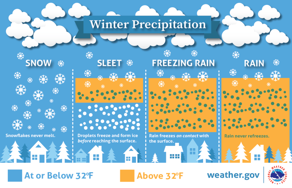
In Fayetteville, temperatures will drop to freezing shortly after midnight, meaning the city will experience a brief period of freezing rain. Bridges and overpasses will be treacherous as ice can form there well before temperatures hit freezing.
By 3 a.m., precipitation will likely switch over to sleet, with the first flakes of snow likely appearing around lunchtime. This changeover will come when temperatures about a mile overhead have cooled to freezing, allowing snow to fall all the way to the ground. Snow should continue through the afternoon into Friday night, tapering off before sunrise Saturday.
Another issue on Friday will be a biting northeast wind. Gusting up to 25 mph all afternoon, the wind will make a cold day even more raw, with wind chills across the region dropping into the mid-teens during the day and possibly single digits overnight.

More: Photos: Snow in the Fayetteville area over the years
Saturday and Sunday will be sunny, but cold. Temperatures will barely top freezing Saturday, then fight to reach 40 Sunday. Lows both nights will drop well below freezing, making roadways hazardous.
I'll update if there are any major changes. In the meantime, look for updates on Twitter.
Got a weather question? Chick Jacobs can be reached at ncweatherhound@gmail.com or NCWeatherhound on Twitter.
This article originally appeared on The Fayetteville Observer: A winter-storm will bring a mix of snow, sleet and ice to Fayetteville

