Weather Permitting: Colder air moving in Wednesday
The pollen onslaught continues across the Cape Fear region, but things will change notably this week.
Ominous yellow clouds of pine pollen moved into Fayetteville last week, adding to the chorus of snorts and sneezes from the worst pollen outbreak in five years.
Now, gardeners and fruit tree farmers are watching the approach of the first major chill to hit the Carolinas in weeks. While Fayetteville and points south of Interstate 95 should avoid frost, areas to the north and west may want to break out the sheets to protect plants lured into flowers by this false spring.
Here's the setup
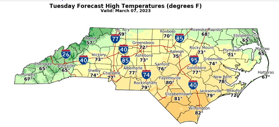
Highs in Fayetteville Tuesday will nudge into the mid-70s.
But there's a major change on the way. A slow-moving backdoor (north to south moving) cold front will sag into the Cape Fear region by late Tuesday afternoon, dropping into South Carolina overnight. It looks like a dry front, so don't look for any rainfall Tuesday.
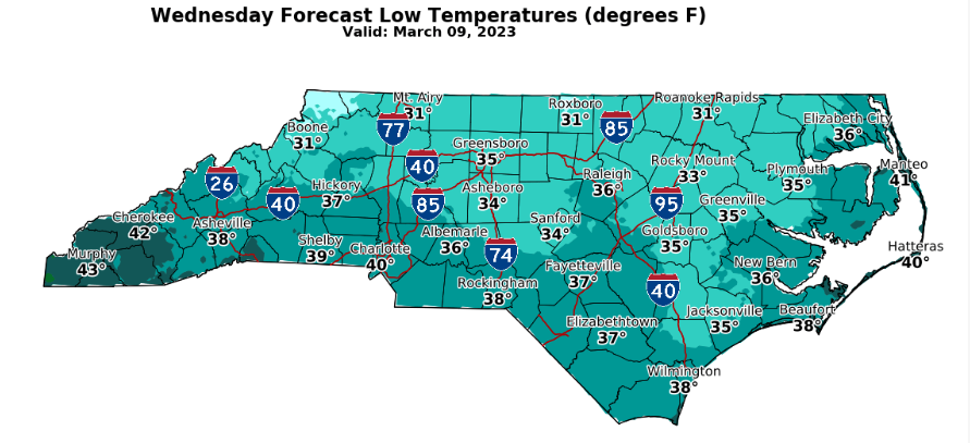
But we'll have wind — a sharp chilly northerly flow will drive temperatures from the upper 70s into the low 40s overnight. Fayetteville will feel much cooler on Wednesday as the wind continues. Highs will stall in the upper 50s with plenty of sunshine.
Overnight, winds will calm down, and skies will remain clear. It's a perfect recipe for radiational cooling, and night-time lows will dive across the region. I wouldn't be surprised to see upper 30s in the city, dropping lower in rural areas.
We'll need to keep an eye on dew points early Thursday morning. With calm air, scattered frost could form on temperatures as high as 36 degrees in sheltered areas. For now, the forecast keeps dew points dry enough to prevent heavy frost, but stay tuned.
The weekend
Friday looks a bit gloomy and chilly, with increased chances of light rain and highs stalling around 50. Saturday improves a bit as another system chases the clouds. Highs will be near 60. Sunday looks sunny, with a high in the low 60s.
Down the road
Even chillier air should begin moving into the Cape Fear region by mid-week. This air has the potential to bring below-freezing temperatures to the north and central region — which is why forecasters have been begging people not to plant yet.
Stay tuned!
Got a weather question? Chick Jacobs can be reached at ncweatherhound@gmail.com orNCWeatherhound on Twitter.
This article originally appeared on The Fayetteville Observer: Weather Permitting: Colder air moving in Wednesday

