Weather Permitting: Could things be heating up in the tropics?
After bragging last week on how well-behaved the tropics have been, it appears some mischief is brewing.
A wave moving east from Africa has been taking a bite out of the dry, dusty air over the Atlantic, essentially priming the pump for future activity.
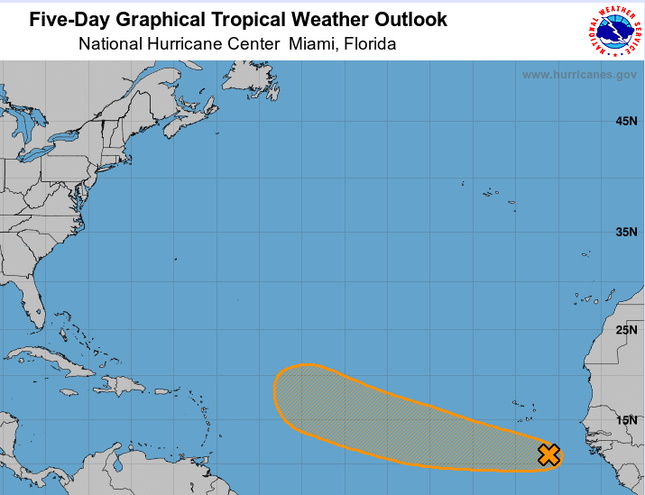
That activity may be at hand. The National Hurricane Center has given the latest wave a near-break even shot at developing by the weekend. Timing and track are still all over the place, and it still may fall victim to the dust and marginal conditions, but if it develops, we'll have Danielle to watch.
Closer to home, the Dog Days continue for the Cape Fear region, with hot, humid days and muggy evenings. For the first time in a while, however, there's a possible cooling trend on the horizon.
Here's the setup
We're starting the week in a classic summer pattern. High pressure near Bermuda continues to pump sultry air into the Carolinas, with temperatures climbing into the mid-90s and the heat index hovering around triple digits. Subtle changes in air currents steer afternoon showers around the state: One day they're crossing the Piedmont, the next along the Coastal Plain.
Overall, chances for rain in the Cape Fear region look spotty, with popcorn showers scattered across the region. Evening temperatures should stay in the low to mid-70s.
For now, Wednesday looks like the hottest day of the week in Fayetteville, say 97 degrees or so. After that, watch for a cold front (well, cooler front — but who's complaining?) to begin digging into North Carolina.
We've had a few such fronts try to reach the region recently, but this one appears to have enough energy to actually get here. If it does, look for widespread showers late Wednesday into Thursday.
More: Weather Permitting: Hurricane season has been quiet so far in 2022. Will it stay that way?
The weekend
Assuming the front can reach the Cape Fear region, showers may persist into Friday morning. Then, as things clear out, we could be looking at what, for August, is a delightful weekend.
Highs will drop into the upper 80s on Saturday and Sunday with lows in the mid-60s. I can hear the air conditioners all over Fayetteville breathing a sigh of relief.
In the tropics
There's a near 50-50 chance we'll see Danielle over the weekend. In the graphic above, you can see some nice cirrus feathering, an indication of calm shear. An earlier wave is essentially plowing the field, knocking down the dry air to the east. And, far to the right, you'll notice two more large waves sliding across Africa.
It appears the Cape Verde season is off and running.
Got a weather question? Chick Jacobs can be reached at ncweatherhound@gmail.com or NCWeatherhound on Twitter.
This article originally appeared on The Fayetteville Observer: Fayetteville, NC weather forecast for the week

