Weather Permitting: Fayetteville area under winter storm watch, snow expected through Saturday
The National Weather Service placed the entire Cape Fear region, as well as much of the Carolinas, under a winter storm watch Wednesday.
It is expected that the watch will be upgraded to a winter storm warning this evening ahead of a sprawling winter storm that will deliver a mixture of snow, sleet and freezing rain through Saturday.
Temperatures will tumble from today's expected high of 60 to highs below freezing on Friday for Fayetteville. Any precipitation that falls will stick to roads and walkways, and there's a good chance the city will see accumulations of sleet and snow through Saturday.
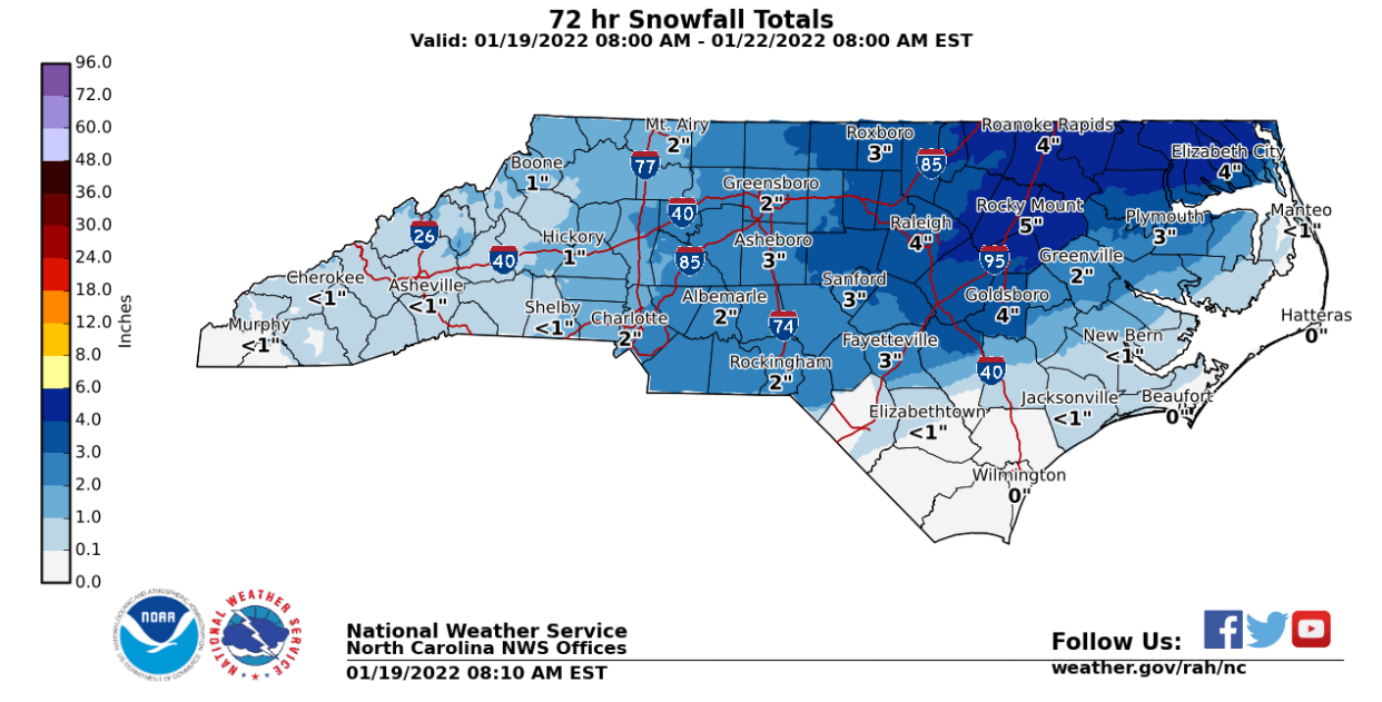
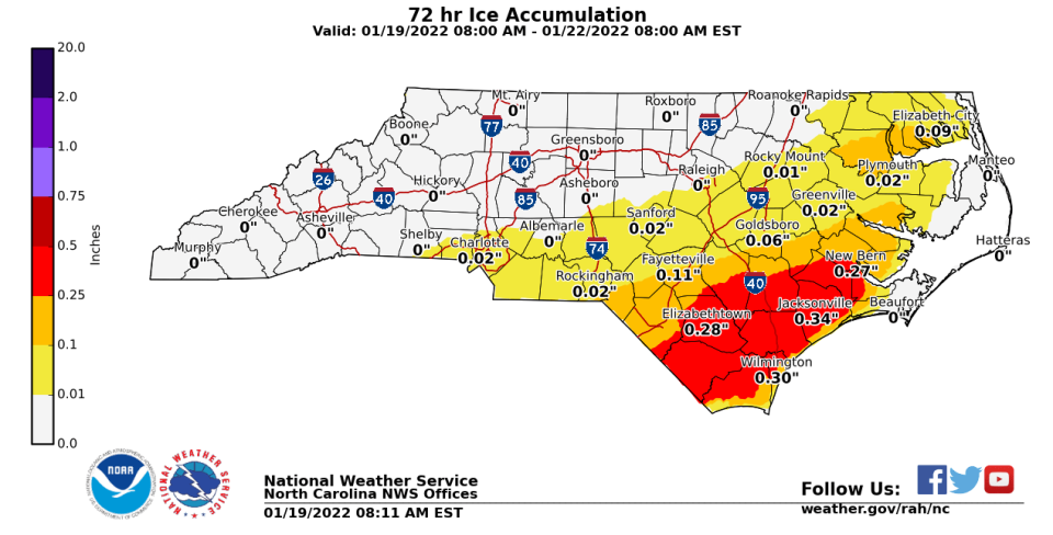
"The southern Coastal Plain and Sandhills could have 0.10 to 0.30" of ice, with the highest amounts across southern Sampson County," the NWS said in a discussion of the upcoming storm.
The NWS in Raleigh notes that conditions remain fluid, and considerable tweaking of the forecast in the Cape Fear region could change.
"Ice and snowfall amounts will likely change in the next two days as models come in even better agreement," the report added.
Unlike last weekend's wintry event, colder air continues to pour into the Carolinas, rather than retreat. Temperatures in the snow-making parts of the atmosphere remain positive, while the "warm nose," a snow-gobbling batch of warm air about a mile up, has continued to shrink.
Still, for at least part of this weekend's event, it's predicted that the warm nose will be strong enough to at least partially melt snow, which quickly refreezes and falls as sleet. Further south and east, the snow remains melted until hitting the sub-freezing surface, instantly freezing as ice.
NCDOT road crews are already preparing roadways with sand and salt.
The general expectation for much of the region is for light rain to begin falling Thursday afternoon. Temperatures will remain above freezing in Fayetteville until after midnight, with rain turning over to freezing rain and sleet before dawn.
Friday will be cold and slick. Depending on mid-level temperatures, sleet will continue through the day, mixing with light snow. Should conditions improve, snow should begin to fall by mid-morning and continue into Friday night.
Farther north, in upper Moore, Lee and Harnett counties, snow is more likely to begin early Friday morning, mixing at times with sleet. Accumulations of 3 inches or more are possible.
To the south, light rain should turn over to freezing rain before daybreak Friday, continuing through the day. There may be periods of sleet, as well. Temperatures will remain below freezing throughout the event, meaning nothing will melt. Travel will be hazardous, and there's a good chance of scattered power outages. There's a chance of brief snowfall early Saturday as the system moves out.
I'll continue to update projections at NCWeatherhound on Twitter. For now, prepare for wintry weather.
Got a weather question? Chick Jacobs can be reached at ncweatherhound@gmail.com or NCWeatherhound on Twitter.
This article originally appeared on The Fayetteville Observer: Fayetteville, NC weather: Winter storm watch, will it snow this week?

