Weather Permitting: Fayetteville experienced a warmer winter than usual
Overnight rainfall helped knock down our prolific pollen around the Cape Fear region, and helped ease dry conditions. Some spots in the southern region picked up more than 2 inches, while the city added about 1.25 inches.
Both the pollen and the persistent dryness were a by-product of an ongoing La Nina, which finally appears to be easing. Now that spring has arrived, let's take a quick look at the "winter that wasn't" for the Carolinas.
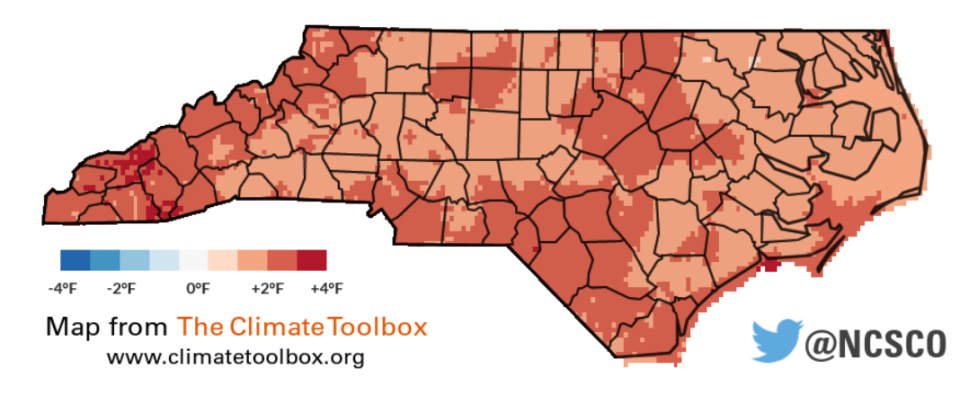
Overall, Fayetteville's winter ran about 3 degrees warmer than normal. Take out that first week around Christmas, when temperatures dropped into the 20s, and it was closer to 4 degrees: Fayetteville saw the warmest February day (85 degrees) on record, and both January and February ranked in the top-10 warmest on record.
Small wonder everything started blooming and budding weeks ahead of schedule.
As far as precipitation, the region had a nice stretch of rainfall in late January and early February. All in all, however, it was a typical La Nina pattern as high pressure shunted rain (and what meager snow was available) well to our north.
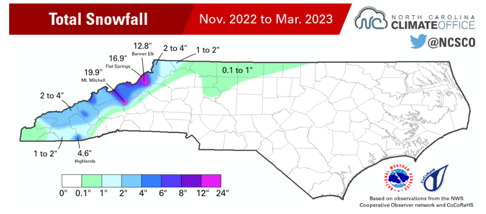
We're used to snowless winters in Fayetteville, but Asheville? This was only the second winter since 1965 that they failed to record measurable snowfall. It was a miserable year for the ski resorts, as none picked up more than 18 inches of snow.
What's this mean for spring? Over the past couple of weeks, the tropics have sent a strong signal that our three-year La Nina is ending. Conditions this spring should be closer to normal. That's good news for dry areas of the Cape Fear region that depend on spring rainfall.
It also means we should have seen our last bout of freezing weather, though frost could be an issue for a couple more weeks in traditionally cooler areas. In fact, what looked like a potential freeze in last week's modeling has modified into only slightly cooler than normal weather this week.
This week will see some unsettled weather as a pair of frontal boundaries push through the region. The first pushes through on Tuesday, holding highs in the upper 60s, then upper 50s on Wednesday. Lows across the region will stay well above freezing, however.
After a pleasant Thursday, with highs near 70 in Fayetteville, Friday will be warm and breezy ahead of the second front. The weekend, especially Saturday, looks warm and a bit muggy, with a chance of showers increasing. We'll know more as the week unfolds.
Have a great week!
Got a weather question? Chick Jacobs can be reached at ncweatherhound@gmail.com or NCWeatherhound on Twitter.
This article originally appeared on The Fayetteville Observer: Fayetteville, NC weather forecast for the week

