Weather Permitting: Which will get here first, cool weather or hurricane?
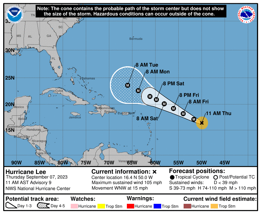
All eyes are watching what will become major Hurricane Lee this weekend.
But in the Cape Fear region, there's something else to watch — a strong front that could finally snap the scorching heat of summer.
The question: Which will arrive first?
As of now, modeling universally turns Lee to the north before threatening the Carolinas, but that's well beyond the 5-day outlook. We'll need to keep an eye on how things develop.
One of those developing things is a potent trough expected to arrive in the Carolinas early next week. With it, temperatures will drop a good 10 degrees or more.
Here's the setup
A weak frontal boundary was slowly pushing into North Carolina on Thursday but is expected to stall before getting to the region. We may see some showers walk down from the Piedmont in the late afternoon and evening, especially in the western region, but overall just another hot day in Fayetteville with a high in the upper 90s.
Overnight lows haven't been all that low, and Thursday night won't be any different. Wednesday's low in Fayetteville set a new "high-low" record at 75 degrees.
Friday will see more clouds across the region and a few more scattered showers. Both will tend to keep the high in Fayetteville a bit lower, say 92 or so. Showers that form won't be severe, and they're scattered enough not to hamper prep football. Kickoff temperatures will be about 82 degrees.
The weekend
More clouds and increasing rain should arrive as a series of weak disturbances cross the Carolinas. Timing and strength are uncertain, but Saturday afternoon looks like a pretty good chance for showers in Fayetteville. Keep an umbrella handy. Highs will hold in the mid-80s, lower in spots that get rain.
Sunday looks similar as the front remains stalled and more impulses cross the region. Highs should stay below 85, given the cloud cover. Showers that occur don't look especially scary and are more likely in the late afternoon and evening.
Down the road
The remnants of the front should move out on Monday, giving us more sunshine and slightly higher temperatures. Monday and Tuesday look good, with highs in the upper 80s and lows of about 68 in Fayetteville. Any rainfall will be widely scattered.
By Wednesday, rain chances increase as a stronger front approaches. This is the trough that is expected to keep Hurricane Lee offshore, and if it arrives before Lee does, the storm has no chance of breaking through.
In the tropics
Lee will develop into a formidable storm over the weekend. Multiple models boost it to a Category 4 Hugo-esque buzzsaw as it approaches the southern Bahamas.
At that point, projections are for it to begin feeling the "tug" of the trough sliding across the eastern U.S. It should then slow down, stall, and turn north, splitting the Atlantic between the Outer Banks and Bermuda.
That's how things are supposed to happen. However, if the "tug" of the trough isn't strong enough early next week, Lee (like Dorian a few years back) could be left behind and spin in the Atlantic as it waits for a push in any direction.
The evolution of steering currents, or synoptics, for Lee is still based on air movement that hasn't evolved yet. We'll need to keep an eye on that developing flow as much as we watch the building storm over the next several days.
Stay tuned!
Got a weather question? Chick Jacobs can be reached at ncweatherhound@gmail.com or NCWeatherhoundon X/Twitter.
This article originally appeared on The Fayetteville Observer: Weather Permitting: Here is your weekend forecast for Fayetteville, NC

