Weather Permitting: Freeze advisory Tuesday includes Fayetteville
For the last few weeks, folks in the Sandhills were begged not to start planting early — no matter how spring-like the temperatures.
This week, we'll have the answer as to why.
The National Weather Service in Raleigh has issued a freeze advisory for the entire Cape Fear region early Tuesday morning, including Fayetteville. A Freeze Warning is in place for Moore and Lee counties. Sub-freezing conditions are probable all the way to the coast on Wednesday morning as cold high pressure builds over the Southeast coast.
Things will warm up again toward the weekend, but another bout of cold air will arrive after that.
Here's the setup
Clouds and the remnants of Sunday's gloomy weather will linger over North Carolina for much of Monday. We'll be lucky to see the high side of 55, with clouds beginning to break up later in the day.
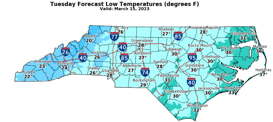
Monday evening will see a passing cold front bring much cooler air into the region. That, with clearing conditions, will drive temperatures into the mid-30s for Fayetteville by Tuesday morning. Areas to the north and west will likely drop to freezing by sunrise.
Tuesday will be clear and chilly, with highs in the low 50s — about 10 degrees below mid-March norms for Fayetteville. A cold north wind will add to the misery. Conditions look near-perfect for another round of sub-freezing cold, this time extending deep into the Cape Fear region.
Wednesday looks a little warmer as upper air conditions improve. Look for a high across the region of about 58 with plenty of sunshine. Lows will be close to freezing again for Fayetteville, and freeze advisories are likely for the northern counties.
By Thursday temperatures should return to mid-month norms, low 60s across the region with overnight lows in the low 40s.
The weekend
High pressure moves offshore, with temperatures across the region climbing into the low 70s. It looks like another front will push through overnight Friday. There's a decent chance of rain continuing Saturday morning, with winds shifting around to the west in the afternoon. Highs should be in the mid-60s. Sunday highs will hold in the upper 50s with lows dropping back into the 30s.
Got a weather question? Chick Jacobs can be reached at ncweatherhound@gmail.com or NCWeatherhound on Twitter.
This article originally appeared on The Fayetteville Observer: Weather forecast in Fayetteville, NC for week of March 13

