Weather Permitting: Heavy storms heading for NC. Here's what to expect in Fayetteville
The Cape Fear region — heck, all of North Carolina — will be looking at a split-decision weekend. If you decide to do anything outside, you'd better do it Saturday.
Sunday is looking more and more like a day when any inflatable outdoor holiday decorations in Fayetteville will be in Hoke County by nightfall.
A potent storm system is heading for the Carolinas, bringing heavy rain and blustery winds to the Cape Fear region. Timing and track are still a bit uncertain, but the system will be large enough — and strong enough — to affect the entire state.
Here's the setup
It's a complex one, beginning with low pressure forming in the Gulf of Mexico. High pressure over the Southeast will slide offshore, allowing the low to climb across Florida into the Atlantic coastline.
At the same time, a secondary low is expected to form over the western Carolinas. Between the two systems, a swath of moisture should flow into the Carolinas. PWAT (potential rainfall) levels are projected to climb to near-record levels (2 inches) — perfect fodder for a drenching weekend.
The high will hold on long enough for folks in the Cape Fear region to salvage at least half the weekend. Friday will be pleasant with highs in Fayetteville of about 60 and morning lows Saturday in the mid-30s.
Winds will shift to the east Saturday, with increasing clouds in the afternoon and evening. Still, highs will be about 60 and lows in the mid-40s. There's no hint of rainfall before midnight.
Sunday is a different story. Depending on time and track, both of which are still a bit iffy, the storm system will move in between Sunday morning and mid-day. Additional energy is expected to form over western North Carolina, creating a secondary low. How this moves and when determines who really gets soaked.
Right now, it looks like the heart of the storm will cross the Piedmont-Foothills, but we won't get left high and dry in the Cape Fear region. There's no question that we need the rain, though it would be nice to get it spread out a bit, but hey — beggars can't be choosers.
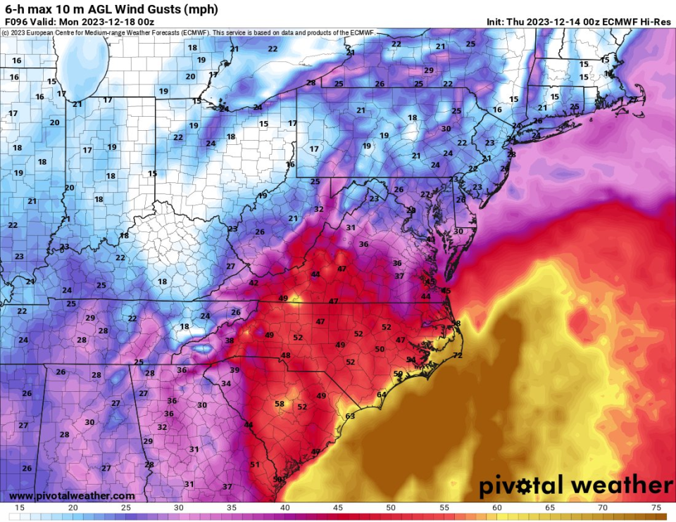
Another issue will be gusty winds. Modeling projects the low at 990-980 mb or lower over the state, easily tropical storm force. In looking through some historical data, I can't find a mid-December storm this potent in our neck of the woods over the last 25 years.
Air layers in winter systems like this don't mix as much as in summer storms. The strongest winds will likely stay aloft, but things will get blustery across the region Sunday afternoon or evening into Monday morning.
Modeling projects gusts in the 40-50 mph range for much of the region after sunset Sunday. So unless you want Santa and Rudolph decorating someone's yard in Raeford, you might want to tie them down.
By Monday the heavy wind and rain should be moving out, but it still looks like a raw, chilly day. Northwest winds will hold the high in Fayetteville below 60.
After that, all we can be certain of is cooler-than-normal temperatures. There's another potential low-pressure system that may or may not form, meaning it may or may not rain. We'll have to hold out a few days on that one.
Have a great Saturday — and hunker down on Sunday!
Got a weather question? Chick Jacobs can be reached at ncweatherhound@gmail.com or NCWeatherhound on X/Twitter.
This article originally appeared on The Fayetteville Observer: Fayetteville to see strong storm this weekend

