Weather Permitting: Here's your Fayetteville-area weekend forecast
The Cape Fear region remains in the middle of a traditional summer pattern — a bit hot, a bit muggy, and just enough afternoon shower activity to make outdoor plans a bit dicey.
At least everyone has seen some rain this month. A few folks have seen more than enough. While the Fayetteville airport has officially recorded .8 inches of rain, the northern part of Cumberland County and spots around Stedman have collected as much as 5 inches.
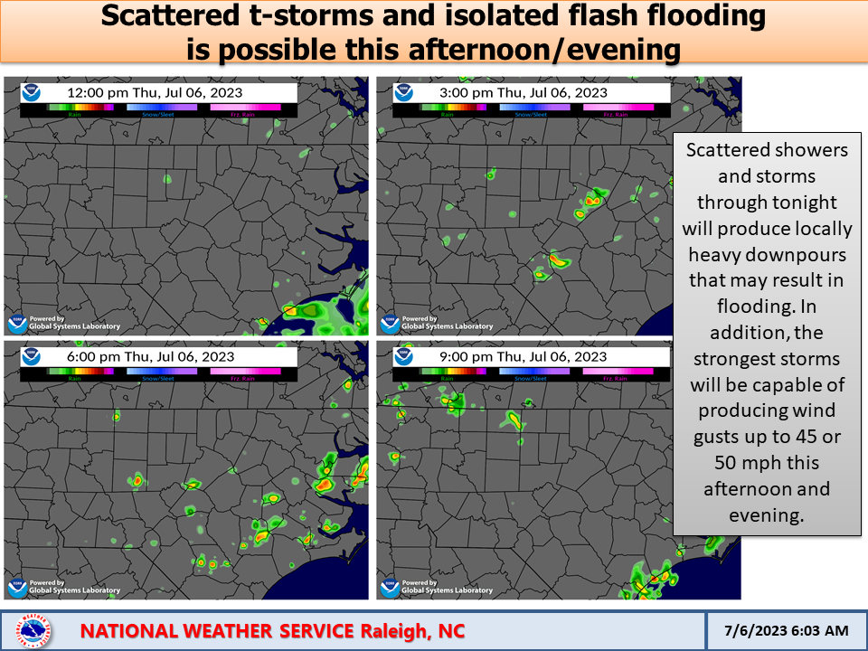
Scattered showers will continue through the weekend. While it's impossible to say who's going to get them, there's a pretty good idea when they'll arrive. Just keep an umbrella handy through the weekend.
Here's the setup
Warm humid high pressure continues to sit over the Carolinas, while a weak boundary slowly slides offshore. A series of impulses will slide along the boundary, each tapping into the heat and humidity to produce thunderstorms.
In addition, the usual popcorn showers will fire up in the afternoon and evening across the region. These are more likely south and east of Interstate 95, but with the PWAT (potential rainfall) levels above 2 inches across the region, anybody could see a soaker.
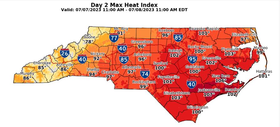
Depending on showers, highs across the region should push into the low 90s through the weekend. Right now, Friday is looking like the hottest day in Fayetteville with a high near 95 and a heat index back in the triple digits. Overnight lows will stay above 70, except where rainfall has cooled things off.
The weekend
One of those impulses is expected to slide through the Cape Fear region late Friday or early Saturday. Rain chances ease early Saturday, then pick back up in the afternoon. Look for sunshine in between, with highs in the low 90s.
Rain chances are higher on Sunday as another impulse slides through. Timing isn't set yet, but given the widespread warmth and moisture, coverage should be widespread when it arrives. Highs will depend on cloud cover, but the low 90s are a good guess.
Next week
Monday may be a bit stormy as another front taps into the moisture and instability. After that, things will calm down for a few days with slightly cooler temperatures and drier air.
In the tropics
All quiet as the Sahara Dust Layer and shear continue to knock down potential systems. Looks like another clear week.
Got a weather question? Chick Jacobs can be reached at ncweatherhound@gmai.com or NCWeatherhound on Twitter.
This article originally appeared on The Fayetteville Observer: Weather Permitting: Your Fayetteville, Cape Fear region weekend forecast

