Weather Permitting: Nature's fireworks could hit the Fayetteville area on Wednesday
After much-needed, if scattered, showers, soaked parts of the Cape Fear region overnight, folks are a bit concerned about the chance for showers dampening regional fireworks displays tonight.
There may indeed be a few stray storms, but it looks more like nature's fireworks will hold off until Wednesday.
We have a fairly normal look for the Cape Fear region on the Fourth: hot, muggy and perfect for gnats, while showers slip through the region in the early evening. By the time most organized shows begin, after 9 p.m., afternoon heating will be easing up. This robs the popcorn-type showers of enough energy to continue.
So, I'd look for a slightly sticky summer's evening — enjoy the show!
Election coverage: Early voting in Fayetteville City Council races starts this week. Here's what to know.
The Fourth of July: What fireworks are legal and where to buy them in the Fayetteville area
Here's the setup: Weak high pressure to our north doesn't have the push to break the summer swelter in this neck of the woods. Up toward Virginia, dew points are in the low 60s. Down here to the coast, it's the low to mid-70s. There's plenty of heat and moisture for storms to feast on, but little in the way of triggering — except, perhaps along the Sea Breeze Line well south and east of I-95. Unless the boundary to our north manages to push closer, the usual popcorn showers will be the only concern.
Look for these conditions to hold into the evening after a high of about 92 in Fayetteville. Temperatures when the fireworks start should be around 85, with a heat index hovering near 90. Carry some water — and bug repellant.
Conditions on Tuesday look similar, with a high in Fayetteville of about 93 and a heat index approaching triple digits. Overnight lows will stall at about 76, and with a dew point in the mid-70s, morning fog is possible.
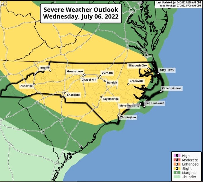
Wednesday has a chance of severe weather as another front creeps into the state. It's going to be hot — 95 in Fayetteville — and muggy. The regional heat index could trip advisories by afternoon with readings of 105 degrees.
Column:Fayetteville City Council candidate is a Proud Boy
Read this: What's Happening? 5 upcoming events in the Fayetteville area
In addition, it looks for now like the boundary will stall just to our north, adding instability to the atmosphere. Modeling is near-unanimous for storms to pop up in the afternoon, lasting into the evening. Some could include hail and damaging wind, leading the Storm Prediction Center to place us under a Level 2 storm projection.
The rest of the week looks about the same: hot and muggy, with scattered showers.
The weekend: Look for another front to approach late Friday into Saturday, and this one should have enough power to push through the state. Unsettled conditions are likely as the front approaches, with clearing, cooler and much drier conditions on Sunday.
In the tropics: Bonnie and Colin have come and gone, and things are settling down. Sahara dust should hinder any Atlantic development for the time being.
Have a great week!
Got a weather question? Chick Jacobs can be reached at ncweatherhound@gmail.com or NCWeatherhound on Twitter.
This article originally appeared on The Fayetteville Observer: Fayetteville weather: Storms could hit area on Wednesday

