Weather Permitting: Soggy weekend is in the cards for the Fayetteville area
A blustery storm system tracking along the Carolina coast will put a damper on weekend outdoor plans in the Cape Fear region.
The system, spinning up later Thursday off the Florida coast, thankfully won't have time to become a potent tropical storm before affecting the region. But Fayetteville will see increasing wind and on-and-off showers through Saturday before things clear up on Sunday.
Here's the setup
There's a decent chance that the system off Florida will develop into a tropical or subtropical depression by the time it reaches the North Carolina coast on Saturday. But the effects of the system will reach the Cape Fear region, especially east of Interstate 95, well before then.
There's little question that the system will track along the coast, perhaps coming inland further east. Steering patterns all but force it to slide up the Carolina coast through Saturday, then head north or northeast. Strength is pretty well projected, too, with a center just shy of tropical storm strength expected.
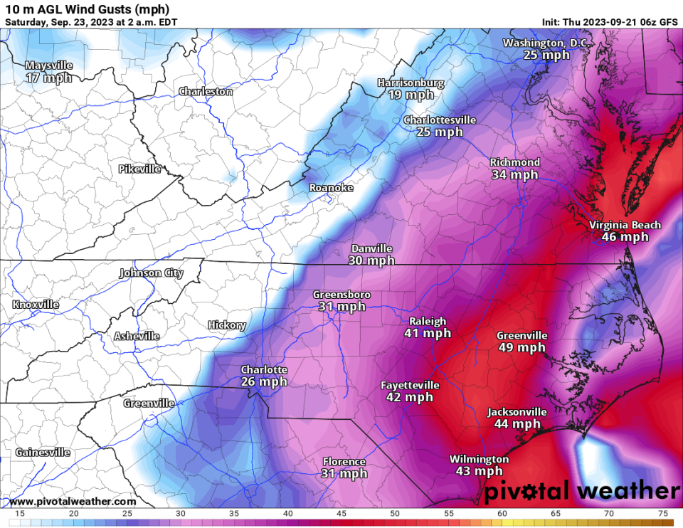
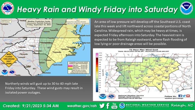
Ahead of the system, an approaching trough and the backside flow of the storm will create a fairly decent pressure gradient on Friday. Winds from the northeast will pick up during the day with gusts topping 30, perhaps 35 mph in Fayetteville by sunset. Clouds will increase during the day as well, holding highs in the region in the mid-70s.
Rainfall will drop off sharply from east to west Friday evening, with the heavier totals east of I-95. Spots in Moore and Richmond counties may only see sporadic showers. Closer to the coast, rainfall could be heavy at times. In between, Fayetteville can look for passing bands of showers through the night with a low of about 65.
Saturday looks iffy, depending on the timing and track of the system. Generally, the further south and east you are in the region, the more likely you'll be to see heavy rain and squalls.
Fayetteville should start the day cloudy and blustery with on-and-off showers. Rainfall should be lighter, but winds gusting above 30 mph continue through the day. We may not top 70 for a high and sunshine will be scant. Total rainfall from the system should range in the 1.5-inch area over the weekend.
By Sunday, dry weather returns as the storm moves up the coast. Winds die down to a light northerly flow and sunshine returns.Look for a high in the upper 70s to 80 for Fayetteville, with an overnight low of about 62.
Down the road
Early next week looks pleasant, with sunshine and highs in the low 80s. By midweek look for another approaching front to bring unsettled weather for a day or two.
In the tropics: Aside from our weekend system, Nigel is expected to remain well out to sea. However, another well-defined system has moved off of Africa, and several models project it to get close to the Leeward Islands next week. It's something to watch for future development.
Stay tuned!
Got a weather question? Chick Jacobs can be reached at ncweatherhound@gmail.com or NCWeatherhound on X/Twitter.
This article originally appeared on The Fayetteville Observer: Weather in Fayetteville, N.C.

