Weather Permitting: Summertime heat will start building again
The Cape Fear region will see one more day of sunshine and highs in the 80s. Then — well, it IS summertime, after all.
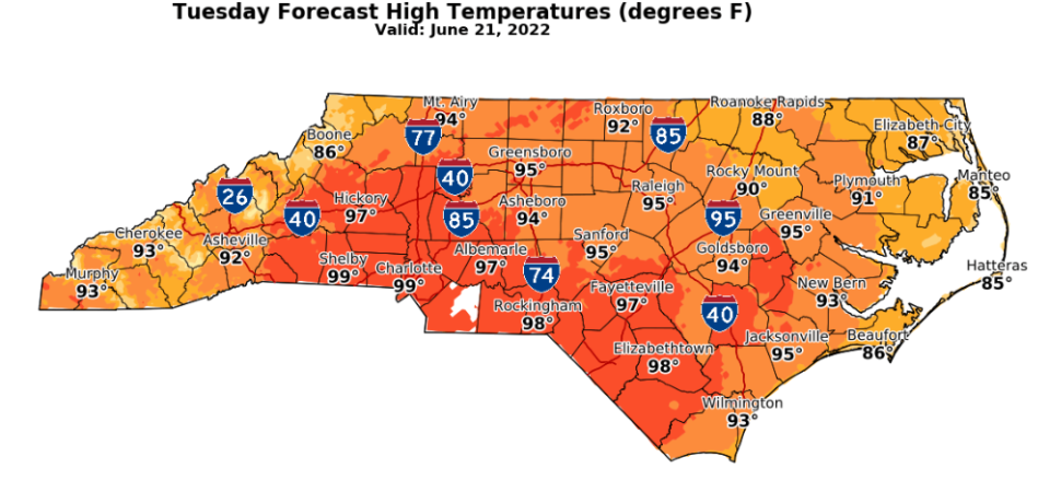
The pleasant stretch of weather dominated by cool Canadian high pressure will move out, and those steamy, sticky days of summer return. It won't be as perilously unpleasant as last week, but Fayetteville can look for highs in the mid-90s by midweek. There's also a chance that another batch of strong storms will slide through the Cape Fear region as well later this week.
Here's the setup
The stretch of pleasant, below-normal warmth that graced North Carolina this weekend is slowly sliding offshore. Farewell highs in the low 80s, lows in the upper 50s and dew points in the 40s.
Previously: Weather Permitting: Here's how to stay cool during Fayetteville's brutal heat this week
More: Ten Cumberland County schools to get new principals next year
Instead, the traditional southern ridge will begin to nudge east of the Appalachians on Tuesday, prodding afternoon highs back toward the 90s. Fayetteville may hold on for one more sub-90 day on Tuesday, but not by much. I'd expect us to nudge just above 90, with no expectation of clouds or showers.
The approaching ridge isn't quite as hot as last week's, but it's still unpleasant. Wednesday highs across the region will climb into the upper 90s. then moderating slightly toward the weekend. The easing of heat is expected because of the ridge slipping back to the west a bit, increasing the chances for afternoon and evening showers.
There's also the possibility of another round of storm clusters riding the edge of the ridge into the Carolinas. For now, it's impossible to say if or where such storms would pop up, but it's something to keep an eye on.

And, once again, those storms are scattered, meaning some — but not all — of the region would see potentially heavy rain totals. Last week, portions of Scotland and Richmond counties picked up 6 inches of rain, while other spots got shut out.
Down the road
A typical Cape Fear region summer pattern appears to be in the works as we head into the weekend. Look for highs in the low 90s with a heat index flirting with 100 most days. Scattered afternoon and evening showers will offer some relief, with lows in the low 70s.
Some modeling tries to develop low pressure over the region, which would enhance rain chances. Given the ridge's retreat, it's something to keep an eye on.
In the tropics
Activity is limited to clusters of showers deep in the Gulf and off the African coast. Don't look for any development for the rest of this week.
Have a great week!
Got a weather question? Chick Jacobs can be reached at ncweatherhound@gmail.com or NCWeatherhound on Twitter.
The Fayetteville Observer app is free to download.
This article originally appeared on The Fayetteville Observer: Summertime heat will start building again in Cape Fear region

