Weather Permitting: Winter storm headed to Fayetteville area Sunday. Here's what to expect.
The week began in the Carolinas with hopes of a winter wonderland.
It is quickly sliding into a bit of an icy nightmare.
A complex scenario of cold air, a warm nose and bad timing threaten to turn the Cape Fear region into an ice rink Sunday morning as a winter storm system bears down on the Carolinas.
A few days ago, this system looked as if it would be simply a rain/snow event," said Tom Green in a forecast from the National Weather Service in Raleigh. "Over the last 72 hours, the westward trend of a surface low moving farther inland makes a widespread significant icing event likely west of I-95."
Adding insult to icy injury, forecasts introduce a quick end to moisture on the backside of the storm, removing potential snowfall late Sunday.
For now, it would be wise to prepare for the usual problems that come with ice. In addition, winds Sunday may gust to 25 mph, and any weakened branches coated in ice could easily snap and fall across power lines.
It's a messy outlook, so let's get started:
The setup
The weekend begins calmly with sunshine and highs in the mid-50s for the region. It will be breezy, however, with northwest winds up to 20 mph. Lows Friday night will drop to near freezing.
Saturday will see a news surge of cold work into the region. Highs will likely stall below 45 degrees, with a chilly northeast wind. The scenario usually creates a cold air damming event as cold air is shoved against the mountains.
Saturday night, temperatures in the Cape Fear region will drop into the upper 20s, with a wind chill in Fayetteville in the upper teens. Meanwhile, a low-pressure system will approach, triggering the development of a secondary low.
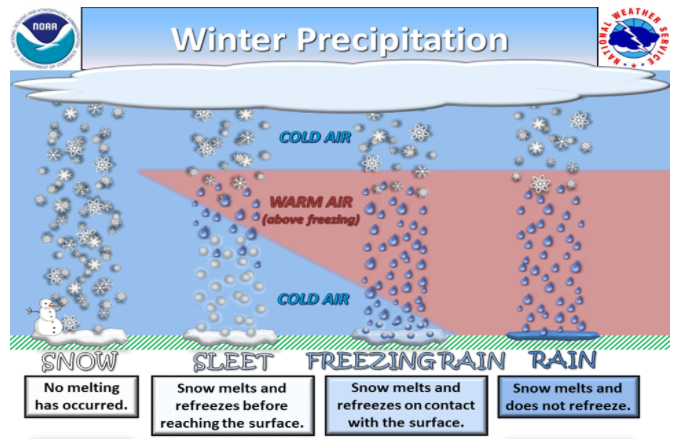
This is the system that creates our mess on Sunday. With cold air locked in place at the surface, the offshore low pumps much warmer air into the mid-levels of the atmosphere. As a result, any snow created must pass through this warmer air. Much of what Fayetteville sees Sunday morning is expected to be melted, refrozen pellets of sleet.
Of more concern is melted precipitation that falls later, refreezing on roads, walkways and power wires as layers of ice. Current projections are for Fayetteville to end up with a mixture of wet snow, sleet and ice into the early afternoon.
Additionally temperatures are expected to drop to freezing early Monday morning, re-freezing the whole mixture.
Martin Luther King Day will be sunny and chilly, with highs of about 45. A sharp westerly wind will hold wind chills below 40 across the region. The wind should help evaporate remaining moisture, but the region is looking at a hard freeze that night. Lows will likely drop into the mid-20s.
I'll update here if there's any notable change in the forecast. In the meantime keep up with the approaching storm with me on Twitter.
Take care!
Got a weather question? Chick Jacobs can be reached at ncweatherhound@gmail.com or NCWeatherhound on Twitter.
This article originally appeared on The Fayetteville Observer: Winter storm could turn Fayetteville area into icy mess on Sunday

