Weather updates: Beaufort County under tornado watch. Hilton Head Island power restored
Power restored on Hilton Head Island
Updated 4:52 p.m.
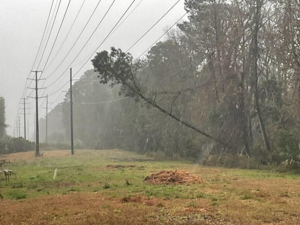
Palmetto Electric restored power to residents who had outages due to a tree that fell on a mid-island transmission line, spokesperson Tray Hunter said.
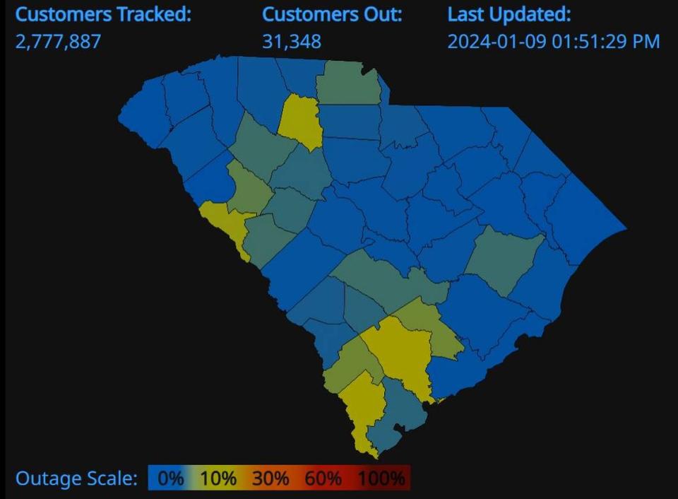
According to PowerOutage.us, 5,636 Beaufort County customers, 4.9%, were without power. Only 36 of those customers were under Palmetto Electric Cooperative and another 5,600 were Dominion Energy customers.
Nearly 17K without power in Beaufort County
Updated 4:05 p.m.
According to PowerOutage.us, 16,741 Beaufort County customers, 14.5%, were without power. Nearly 13,000 of those customers were under Palmetto Electric Cooperative and another 3,785 were Dominion Energy customers.
Palmetto Electric Spokesperson Tray Hunter said the majority of the outages are on Hilton Head Island due to a tree that fell on a mid-island Santee Cooper transition line. He said he didn’t know when power would be back, but they have crews working to restore it.
About 16% of electric customers in Jasper County were without power. About 2,100 Dominion Energy customers had no power, and another 129 outages were under Palmetto Electric Cooperative.
Severe thunderstorm warning extended
Updated 3:35 p.m.
The NWS extended Beaufort and Jasper counties’ severe thunderstorm warning until 4:30 p.m. The warning noted that winds could reach up to 60 mph and pea-sized hail is possible.
Road closures
Updated 3:30 p.m.
Beaufort Police alerted that northbound lanes on US21B/ Boundary Street at Lafayette Street are closed until further notice. Expect delays in the area, the traffic advisory said.
Updated 4 p.m.
All lanes of Boundary Street have reopened.
Swearing-in ceremony postponed
Updated 3:25 p.m.
Bluffton Mayor-elect Larry Toomer’s swearing-in ceremony, which was scheduled for 5:30 p.m., has been postponed. The swearing-in has been rescheduled for 5 p.m. Jan. 16, according to the Town of Bluffton.
Severe thunderstorm warning
Updated 2:45 p.m.
The NWS triggered a severe thunderstorm warning for Beaufort and Jasper counties that will lift at 3:45 p.m. Severe thunderstorms were located along a line “extending from near Shawnee to Allenhurst, moving northeast at 55 mph,” the service wrote.
NWS said the impact will be 60 mph winds and to expect damage to trees and power lines.
The warning is issued when either a severe thunderstorm is indicated by the WSR-88D radar, the NWS said, or a spotter reports a thunderstorm producing hail 1 inch or larger in diameter and/or winds equal or exceed 58 mph. The service urged people in the affected area to seek safe shelter immediately.
Storm damage report
Updated 2:35 p.m.
A tree fell on a parked pickup truck at about 1:49 pm on Simmonsville Road near Sundew Court, said Sgt. Bonifacio Perez of the Bluffton Police Department. Perez said there were no injuries, and that it’s the only big storm-related call the department’s gotten so far today.
Power outage updates
Updated 2:10 p.m.
Beaufort County’s power outages totaled 1,127 customer, 254 were Dominion Energy customers and 873 were Palmetto, according to PowerOutage.us. Jasper County had about 1,500 customers without power, or 10% of electric customers.
Updated 12:45 p.m.
Beaufort County’s power outages ticked up to 472 Dominion Energy customers without power, according to PowerOutage.us. Jasper County power outages had jumped to 1,506.
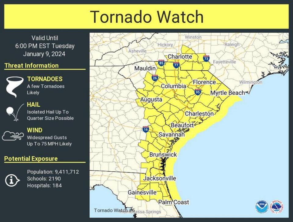
Beaufort and Jasper counties under tornado watch
Updated 11:45 a.m.
The NWS triggered a tornado watch, lasting until 6 p.m., for Beaufort and Jasper counties. The service said hail up to 1/4-inch is possible and winds could gust up to 75 mph.
A tornado watch means tornadoes are possible in and near the watch area, the NWS noted. The service added that the watch area is typically large, covering multiple counties or states.
The service urged residents to review and discuss emergency plans, check supplies and a safe room. If a tornado warning is later issued, indicating a twister has been sighted or seen on radar, preparedness will be beneficial.
Daufuskie Island Ferry update
Updated 11:40 a.m.
At 4 p.m., the Daufuskie Island Ferry will be “suspending services,” said Hannah Nichols, spokesperson for Beaufort County. The ferry will resume its services Wednesday.
Jasper County power outages
Updated 11:30 a.m.
While Beaufort County only had two documented power outages at the time of this update, according to PowerOutage.us, Jasper County’s outages were mounting. Between Dominion Energy and Palmetto Electric Cooperative customers, 871 did not have power.
Savannah/HHI airport update
Update 11:05 a.m.
Lori Lynah, the airport’s director of marketing and air service development, said “while there are currently no significant delays, there are flights being diverted from Atlanta to Savannah.”
Passengers should check with their airline first, either on the airline’s website or their app, for the most current information, Lynah said. She added that the airport expects the storm will hit hardest in the area between 3 and 5 p.m.
Four arrivals and and four departures were delayed at the time of this update. One departing flight to Chicago was canceled.
City of Beaufort offices to close
Updated 10:10 a.m.
At noon, the City of Beaufort will close its offices. Its city council work session and regular meetings, which are scheduled for 5 p.m. and 7 p.m., are still expected to take place, according to an email from the city spokesperson.
Popular outlets close
Updated 9:40 a.m.
Tanger Outlets Hilton Head and Tanger Savannah are closed due to severe weather threats, the popular shopping-mall chain announced on Facebook.
Local colleges, schools shuttered
Updated 9:30 a.m.
The University of South Carolina - Beaufort and the Technical College of the Lowcountry instructed faculty, students and staff to work remotely, according to their Facebook pages. The facilities are closed.
Late Monday, Beaufort County schools and offices shifted to a remote workday and learning.
Thrashing winds and heavy rain
Updated 8:30 a.m.
Along Battery Creek Bridge, in Port Royal, palm trees lining the way thrashed in the wind, sheets of sideways rainfall blurred road lines and water pooled on the sides of the road. The typically busy Ribaut Road had few cars and scattered palm fronds on it.
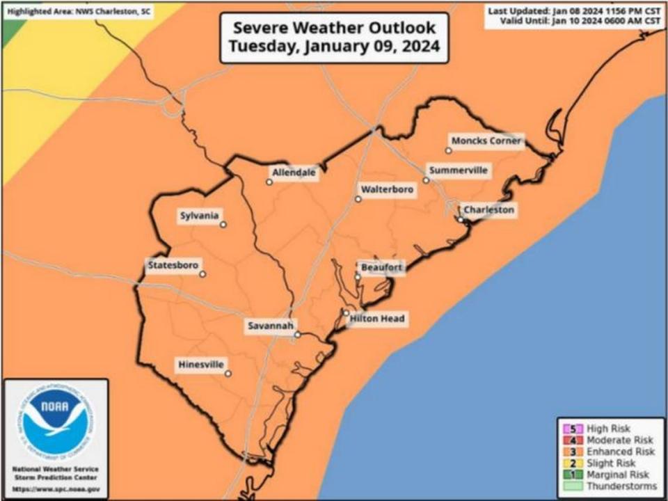
Storm’s highest threats coming in the afternoon
Updated 8:30 a.m.
What the National Weather Service calls an “unusually” strong storm is set to rumble through the Lowcountry, with its main and most severe impacts kicking up at 2 p.m. Tuesday.
Expect strong winds, possible severe thunderstorms and tornadoes, and dangerous beach and marine conditions, the service’s 6 a.m. Tuesday briefing said.
Wind gusts could cap at nearly 60 mph, which could fell trees, damage power lines and make travel difficult, particularly across elevated surface areas like bridges. Wind gusts may reach up to 60 mph, which is 14 mph below Category One hurricane speeds.

As of Tuesday morning, PowerOutage.us showed no power outages in the county.
For those in Beaufort County, the Talmadge Memorial Bridge, heading into Savannah, and Woods Memorial Bridge, connecting to Downtown Beaufort, are points of concern if winds get too strong. Sustained winds will reach up to 40 mph.
The service’s Charleston Office said Tuesday morning that peak wind speeds are expected in the afternoon. According to local meteorologists, high winds and the potential for tornadoes are the greatest severe weather threats for the area.
“There is a risk of winds or wind gusts exceeding 60 knots/70 mph and a couple significant tornadoes (EF2 or greater),” the Tuesday morning briefing read.
Beaufort County’s chance of tornadoes has remained between 10% and 14%, according to the service. On Monday, Frank Strait, the state’s severe weather liaison, said the incoming thunderstorms have another confounding issue.
The storms “will move unusually fast, perhaps over 60 mph, making it more challenging to effectively warn of their approach,” he said.
Flash flooding is not expected to happen, but the Lowcountry will see a steady stream of rainfall, amounting up to 1.5 inches. The NWS predicted storm-force winds at sea could climb to 55 knots, with seas up to 17 feet.
As of 8:30 a.m. Tuesday, several departures out of the Savannah/Hilton Head International Airport showed in-air diversions and delays. Two arriving flights were delayed.
The county is under a high wind warning until 10 p.m. and a high surf advisory until midnight.
Local meteorologists expect the storm to be off the coast after 8 p.m. and noted that weather conditions would rapidly improve Wednesday, although gusty winds up to 30 mph would linger.
Reporters Mary Dimitrov, Sonia Clark, Evan McKenna and Sebastian Lee contributed to this report.

