Weather live: Amber ‘danger to life’ flood warning in Northern Ireland as Storm Ciarán heads to UK
- Oops!Something went wrong.Please try again later.
An amber “danger to life” warning is in place for Northern Ireland today as flooding hit parts of the region, ahead of Storm Ciarán’s arrival.
The warning went in effect from 9pm yesterday and remains in place until 9am today, the Met Office said.
They also warned communities in the region could be “completely cut off” for “several days” by floodwater which could cause a risk to life.
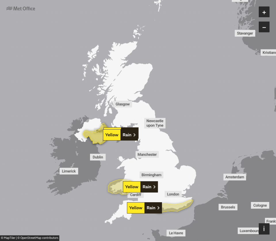
Several yellow warnings have been issued for most of the UK this week as the forecaster warned of “strong winds and heavy rain” with the arrival of the third named storm of the season tomorrow evening.
Gusts of 80mph winds to areas along the south coast of England are expected, while upto 60mm of rain is expected to fall in some areas.
“Heavy and persistent rain will fall onto already saturated ground bringing a risk of further impacts such as flooding in areas that are already struggling to clean up from the heavy rainfall we have seen over the last week or so,” Met office deputy chief meteorologist, Chris Almond, said.
Key Points
Met Office name latest storm set to bring 90mph winds to the UK this week
Staggering number of flood warnings in place
Where will be affected?
How bad will the weather be?
Weather warnings in place this week
Amber weather warnings issued across England and Wales
11:57 , Alexander Butler
The Met Office has issued “danger to life” warnings across southern England as the region is set to be battered by strong winds caused by Storm Ciarán this week.
An amber wind warning has been issued for the south-west and parts of Wales between 3am and 1pm on Thursday. Another amber warning was put in place for the south-east between 6am and 8pm on Thursday.
“Amber weather warnings issued. Very strong and damaging winds associated with Storm Ciarán bringing travel disruption. Large waves may also bring coastal impacts,” the Met Office said on X, formerly Twitter.
⚠️⚠️ Amber weather warnings issued ⚠️⚠️
Very strong and damaging winds associated with #StormCiarán bringing travel disruption. Large waves may also bring coastal impacts
Thursday 0300 – 2000
Latest info 👉 https://t.co/QwDLMfRBfs
Stay #WeatherAware ⚠️ pic.twitter.com/vZ6Z0PVNoU— Met Office (@metoffice) October 31, 2023
Floods connected to climate change, Ireland’s environment minister says
11:24 , Alexander Butler
Flooding caused by Storm Ciarán is connected to climate change with risks more likely in the future due to rising sea levels, Ireland’s environment minister said.
“My heart goes out to those up in Cooley/Carlingford, down in Wexford I know there has been particular flooding, as well as Newry, as well as what happened to Middleton (Co Cork) obviously a few weeks ago,” Eamon Ryan told RTE Radio One.
“Those parts of the country in the south-east tend to be more at risk because of softer ground conditions at the coast. Because there’s also a kind of a longer term trend in terms of that coastline lowering slightly and also obviously rising sea levels.
“So it is connected to climate change. We have to manage and protect our coasts and our people. We can do that, but we have to recognise the reality - the seas are rising, there are particular difficulties also with heavier rains coming, as well as the other elements of coastal erosion.”

Jersey islanders warned of 90mph winds
10:30 , Alexander Butler
Jersey islanders have been warned to remain vigilant amid 90mph winds that are expected to batter the region as Storm Ciarán approaches the UK.
“This is an active situation, and we are closely monitoring the evolving weather patterns and will be releasing further instructions and advice through our official channels in due course.
“We urge everyone to remain vigilant and prepared for severe conditions,” Jersey emergency planning officer Kevin Murphy said.
Bridge collapses in Ireland
10:00 , Alexander Butler
A bridge has partially collapsed in Ireland due to flooding brought on by Storm Ciarán, according to images posted by residents.
The bridge in County Louth, Ireland, was seen with large chunks missing from it as rainwater gushed underneath and through the gaps.
It comes as the Met Office issued a “danger to life” amber warning amid 80mph winds and heavy rain.
Drivers should take ‘extra precaution’, police warn
09:25 , Alexander Butler
Drivers should take “extra precautions” as they drive across the Northern Ireland this morning, according to the Police Service of Northern Ireland.
“Motorists are advised to take extra precautions when driving this morning, as heavy rainfall across the country overnight has left the roads hazardous in some areas,” it said on X, formerly Twitter.
“Keep a safe distance from the car in front and exercise caution at all times.”
Motorists are advised to take extra precautions when driving this morning, as heavy rainfall across the country overnight has left the roads hazardous in some areas. Keep a safe distance from the car in front and exercise caution at all times. pic.twitter.com/HXqjGqEho6
— Police Service NI (@PoliceServiceNI) October 31, 2023
Storm Ciarán tracker: When and where 90mph winds will hit this week
08:43 , Alexander Butler
The Met Office has warned of “strong winds and heavy rain” this week as Storm Ciarán is set to hit the UK.
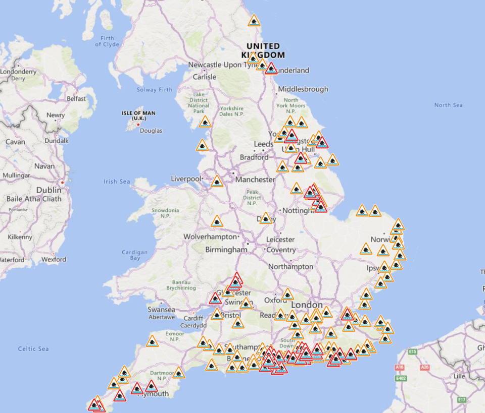
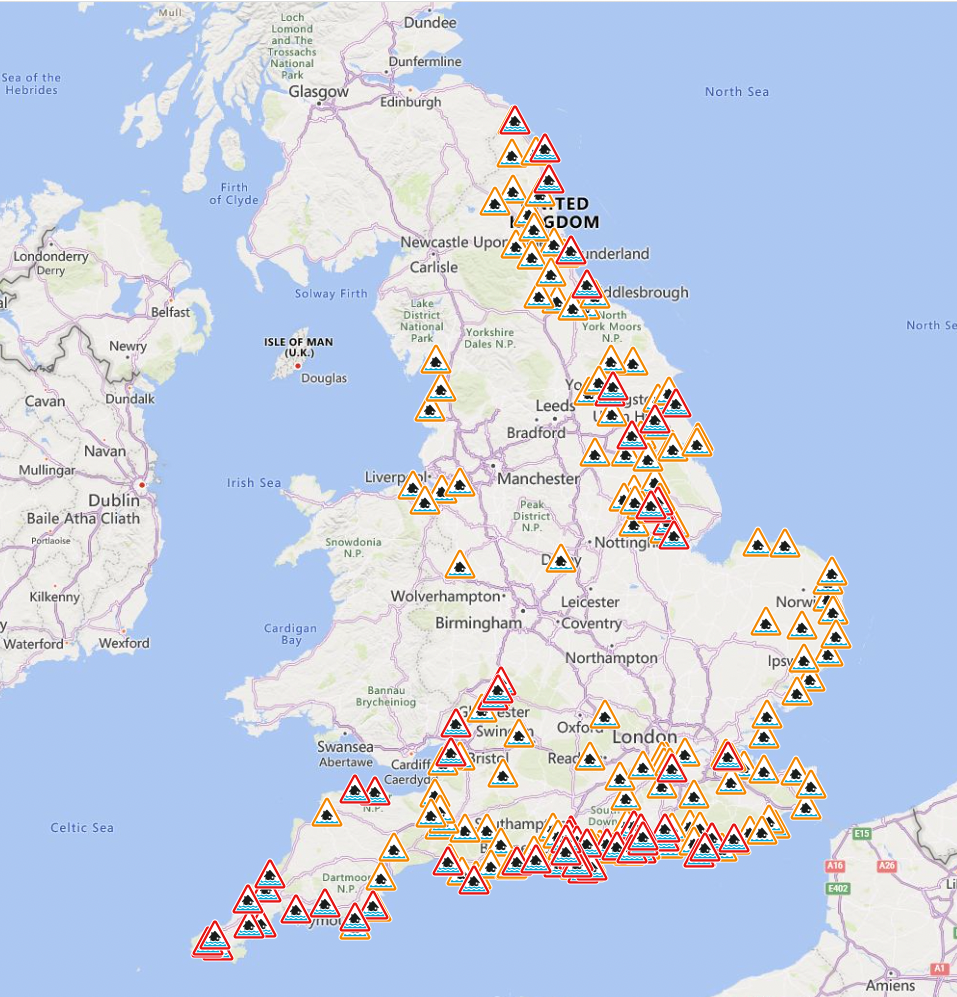
A staggering 72 flood warnings have been issued across England and a further 172 flood alerts, while Scotland has been isued with 18 flood warnings and 11 flood alerts.
Read more here to track when and where the 90mph winds will hit this week:

Storm Ciarán tracker: When and where 90mph winds will hit this week
Warning of more heavy rain to come across Scotland following Storm Babet
07:00 , Lydia Patrick
More heavy rain is expected to sweep over the north east of Scotland in the coming days prompting the Met Office to issue another weather alert.
The latest yellow weather warning for rain covers Aberdeen, Aberdeenshire, Angus, Dundee, and Perth and Kinross – most of which saw prolonged downpours cause problems for residents last week including flooding.
The warning will run from 12pm on Thursday to 12pm on Saturday.
Seven people are known to have died in the UK during Storm Babet, including three people north of the border. They were Wendy Taylor, 57, of Perthshire; John Gillan, 56, of Arbroath; and Peter Pelling, 61, also of Arbroath.
Warning of more heavy rain to come across Scotland following Storm Babet
What will the weather be like this week as Storm Ciarán arrives?
06:30 , Lydia Patrick
As Brits brace themselves for the arrival of Storm Ciarán, here is a look at the weather forecast for the week ahead, with heavy rain pours expected to arrive before the storm makes land.
#StormCiarán will bring disruptive wind and rain to the UK from Wednesday evening and throughout Thursday.
Watch our latest Week Ahead forecast to find out more ⤵️ pic.twitter.com/DzmvvQV5Iv— Met Office (@metoffice) October 30, 2023
Track storm Ciarán
06:00 , Lydia Patrick
The Met Office has warned of “strong winds and heavy rain” this week as Storm Ciarán is set to hit the UK.
A staggering 72 flood warnings have been issued across England and a further 172 flood alerts, while Scotland has been isued with 18 flood warnings and 11 flood alerts.
The third named storm of this year’s season comes after areas across Scotland and north-east England were battered with the worst of Storm Babet, which caused serious damage and several deaths when it hit last week.
Met office Deputy Chief Meteorologist, Chris Almond, said: “Heavy and persistent rain will fall onto already saturated ground bringing a risk of further impacts such as flooding in areas that are already struggling to clean up from the heavy rainfall we have seen over the last week or so.”
Storm Ciarán tracker: When and where 90mph winds will hit this week
More than 70 flood warnings issued ahead of Storm Ciaran
05:26 , Stuti Mishra
Across the UK, the Environment Agency has issued more than 70 flood warnings ahead of the arrival of Storm Ciaran tomorrow while yellow weather warnings for rain have been issued by the Met Office from Monday until Thursday.
Gusts of 80mph are possible along the south coast of England, with 20 to 25mm of rain expected across southern and western areas, but potentially up to 40 to 60mm over higher ground, the Met Office said.
The forecaster advises the latest rain could lead to disruption to roads and public transport while already flood-affected areas after Storm Babet could get worse.
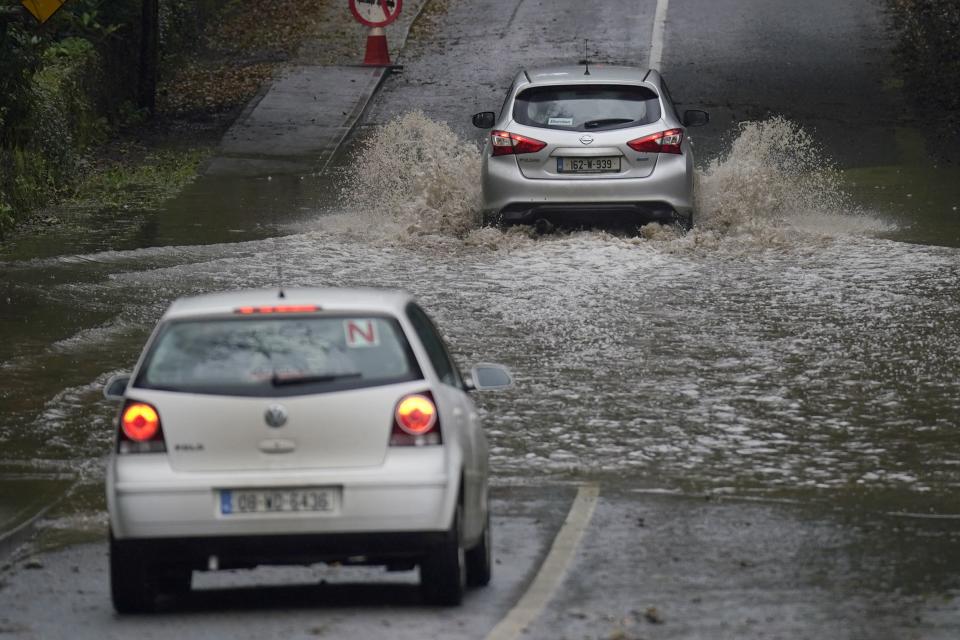
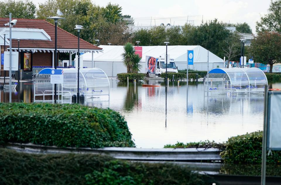
Flooding was seen across Sussex during the weekend, including the Priory Meadow Shopping Centre in Hastings, which was evacuated on Saturday with people posting on social media showing deep floodwater coming through the entrance.
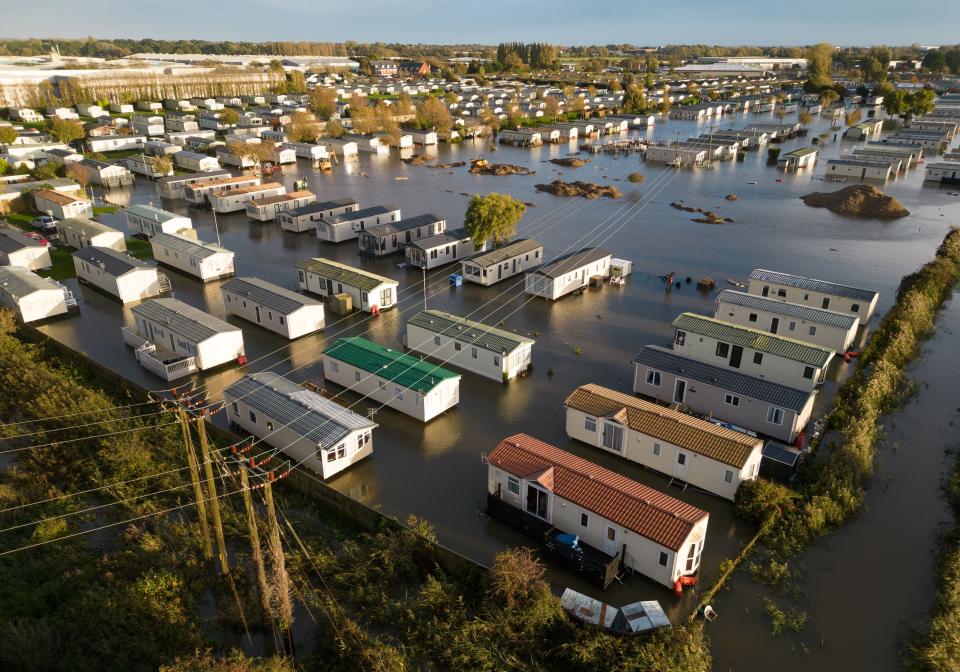
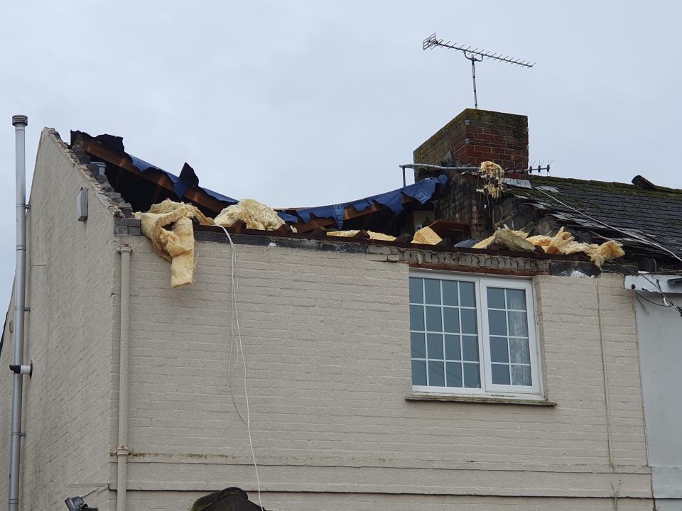
On Sunday, a caravan park in Bognor Regis was also underwater, the town's Tesco supermarket car park was flooded and a house had its roof ripped off in heavy winds that residents described as like a "tornado".
"We've had various warnings in force across the UK over the last few days and there are plenty more being issued for the next couple of days," Marco Petagna, a Met Office meteorologist, said.
"The main focus in the next day or two is towards the east of Scotland and north-east England where there is a yellow rain warning until 3am.
"There will be persistent rain up there and then the focus for heavy showers will be across parts of southern and south eastern England and south Wales as well as parts of Northern Ireland with some heavy and sudden showers."
Read more:
'Please stay at home'
04:37 , Stuti Mishra
Stormont's Department for Infrastructure said police were warning people not to travel during the period the amber warning is in effect.
"These (Met Office) warnings follow an extremely wet weekend where flooding has already occurred on many roads," it said.
"The persistent wet conditions on saturated ground and with higher river levels this will inevitably lead to more localised flooding. Traffic disruption is possible and the public are being asked to consider their journeys and take extra care if travel is necessary."
"It may be necessary to close roads or put temporary restrictions in place."
In a statement, the PSNI said: "Persistent heavy rain will lead to further flooding and we would ask the public to take steps to minimise risk."
"Please stay at home where possible and do not make unnecessary journeys. If you must travel, please bear the prevailing conditions in mind."
"Reduce your speed and drive with extra caution. Excess surface water could lead to aquaplaning, and there is the potential for cars to get stuck in just a few inches of floodwater. Visibility is likely to be severely reduced."
"Consider the potential risks before you leave. Do not place yourself or others in unnecessary danger."
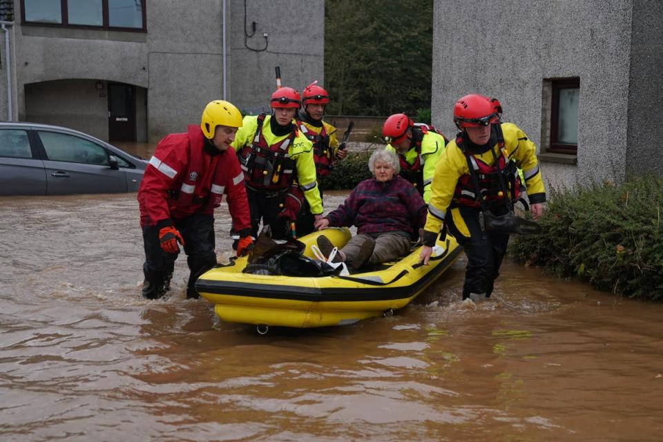
Flooding hits part of Northern Ireland with amber alerts in effect
03:46 , Stuti Mishra
Flooding has been reported in parts of Northern Ireland as police urged people against travelling due to an amber rain warning.
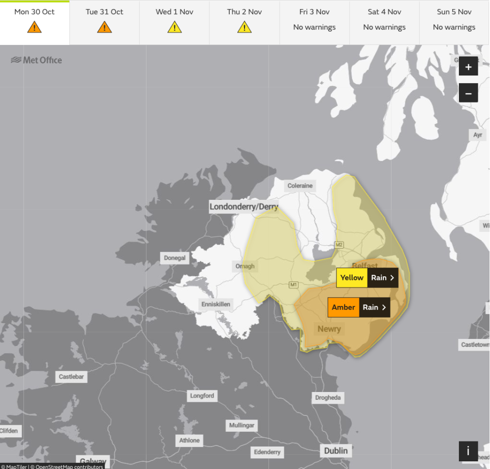
The Met Office has issued an amber warning for rain, the second highest level, for much of the south-eastern part of the region.
The warning covers Counties Antrim, Down and Armagh. It came into effect at 9pm on Monday and extends until 9am on Tuesday.
The Met Office has forecast persistent heavy rain, leading to flooding and transport disruption.
A yellow warning covers the rest of Northern Ireland.
There were reports of flooding in Newry in Co Down on Monday after the city's canal burst its banks.
Elsewhere, roads have been closed due to flooding, while in Dromantine, Co Down, approximately 100 sheep had to be rescued earlier on Monday after becoming stranded in a flooded field.
The Met Office has warned of between 25mm and 50mm of rain in places, and up to 100mm is also possible over higher ground.
Heavy rain expected over next few days as ‘nasty storm’ builds up
02:00 , Lydia Patrick
The UK is braced for another deluge of rain over the next few days as wet and windy weather is expected to build up to a “nasty storm” later in the week.
The Environment Agency has issued more than 70 flood warnings ahead of the UK being hit by Storm Ciaran on Wednesday while yellow weather warnings for rain have been issued by the Met Office from Monday until Thursday.
Gusts of 80mph are possible along the south coast of England, with 20 to 25mm of rain expected across southern and western areas, but potentially up to 40 to 60mm over higher ground, the Met Office said.
On Monday, the worst of the weather is likely to hit the south coast of England, much of Wales and parts of Northern Ireland.
The forecaster advises the latest rains could lead to disruption to roads and public transport while already flood-affected areas following Storm Babet could get worse.

Heavy rain expected over next few days as ‘nasty storm’ builds up
Reports of flooding in Chester
00:00 , Lydia Patrick
There have been multiple reports of floods in Chester as the North West is still recovering from Storm Babet’s destruction.
A Chester business shared their office space had been flooded by rainfall whilst a local bus service reported disruption to their services due to flood waters.
The Independent has not been able to verify these reports.
#Chester.....a flood on Christleton Road is causing delays to our services in and out of town,apologies for the inconvenience
— Stagecoach Merseyside & South Lancashire (@StagecoachMCSL) October 30, 2023
Weather warnings in place
Monday 30 October 2023 21:00 , Lydia Patrick
The Met Office issues an amber “danger to life” weather warning in Northern Ireland today.
Here are the weather warnings in place for the rest of the UK for the remainder of the week.
Tuesday

Wednesday
Thursday
Friday
When will Storm Ciaran hit the UK?
Monday 30 October 2023 20:00 , Lydia Patrick
As Britons recover from the destruction of Storm Babet, Storm Ciaran is set to arrive in the UK on Wednesday, bringing strong winds and heavy rainfall.
The storm will bring powerful winds of up to 90mph and up to 60mm of rainfall in highland areas.
#StormCiarán has been named and is forecast to bring very strong winds and heavy rain to southern parts of the UK on Wednesday night and into Thursday
Stay #WeatherAware pic.twitter.com/wC1NxowSoW— Met Office (@metoffice) October 29, 2023
This evening’s weather forecast
Monday 30 October 2023 19:00 , Lydia Patrick
Heavy rainfall is expected to batter the UK overnight as a ‘danger to life’ weather warning comes into place in Northern Ireland.
Scotland will have a mainly dry night with clear spells and some frost.
Elsewhere there will be some clear spells allowing some fog patches to form, although heavy showers are also likely, especially across Northern Ireland.
What is extreme weather?
Monday 30 October 2023 18:30 , Athena Stavrou
Storm Ciarán is the latest extreme weather event the UK has seen in recent weeks. The third named storm of this year’s season comes after areas across Scotland and north-east England were battered with the worst of Storm Babet, which caused serious damage and several deaths when it hit last week.
From flooding to heatwaves, wildfires to droughts, Earth’s weather cycles have shown signs of becoming increasingly more erratic, severe and prolonged, and though there is no blanket explanation for this change in weather patterns, human-induced global warming is a major underlying factor.
The Independent looks at extreme weather below:
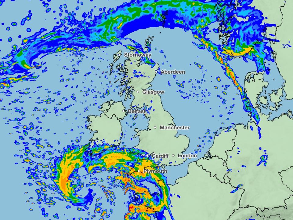
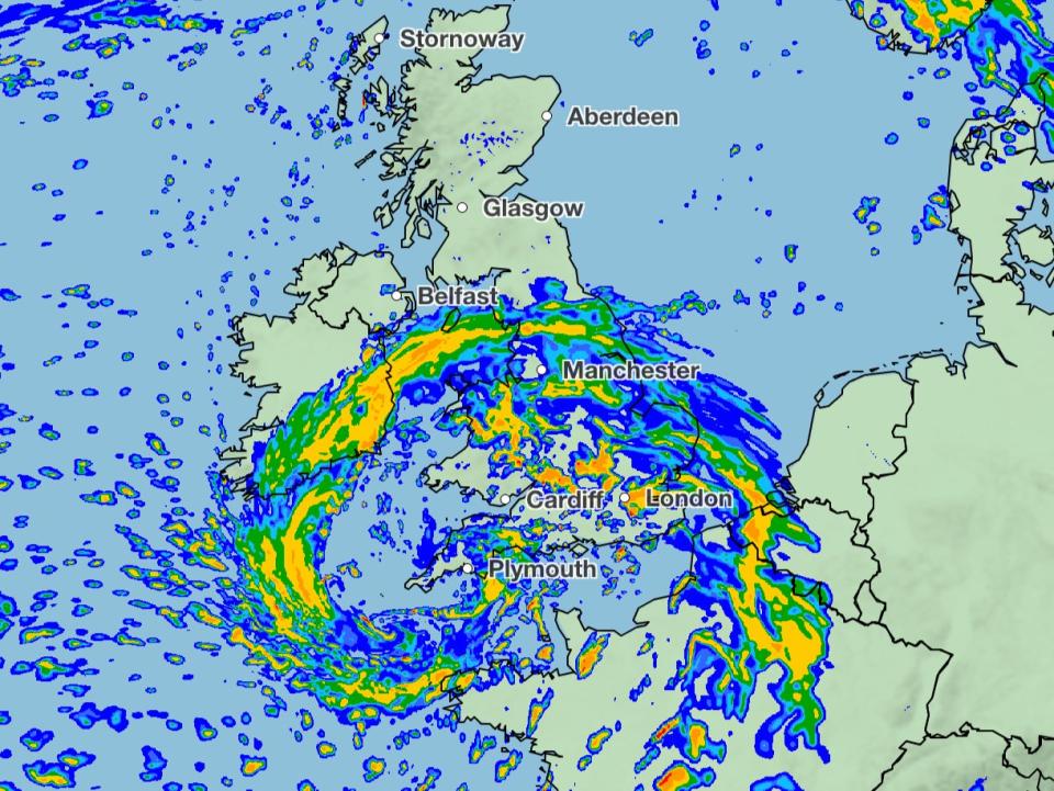
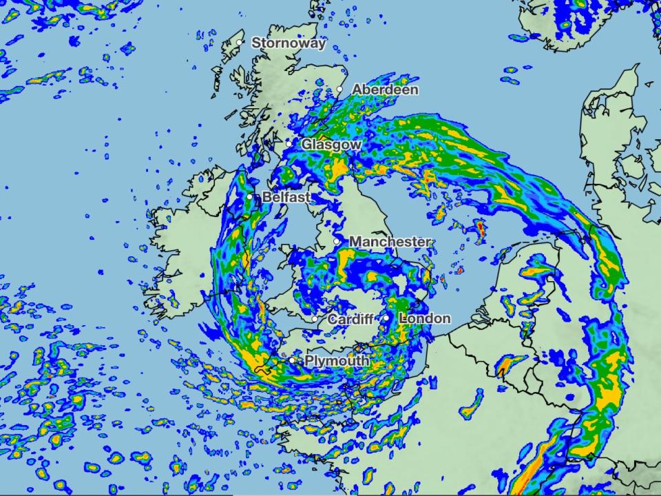
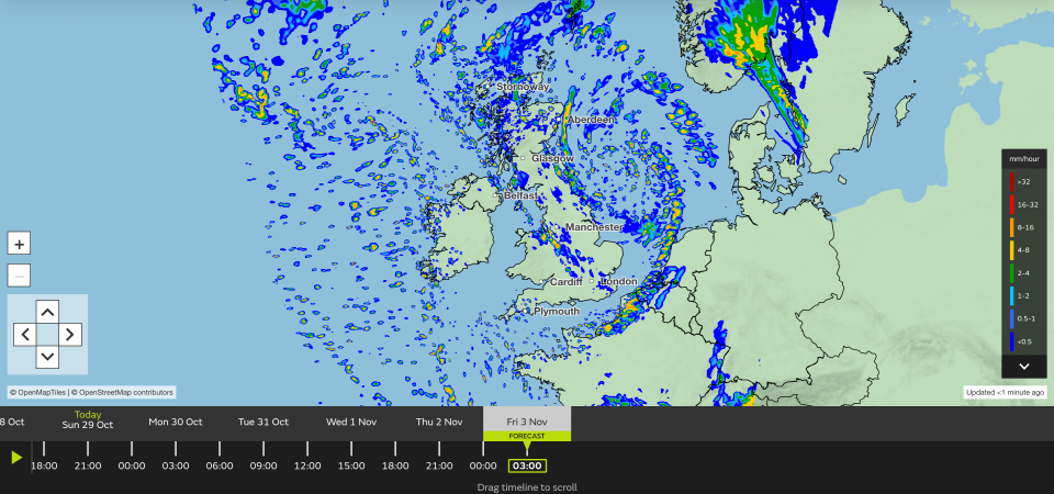
Mapped: Storm Ciarán’s path across the UK
Monday 30 October 2023 18:00 , Athena Stavrou
Here is the predicted path Storm Ciarán is set to take as it sweeps across the UK from Wednesday night.
Advice for travelling in storms
Monday 30 October 2023 17:30 , Athena Stavrou
With Storm Ciarán set to batter the UK on Thursday, here’s the Met Office’s advice for travelling in a storm:
If heavy downpours are expected, avoid starting your journey until it clears.
If you can, choose main roads, where you are less likely to be exposed to fallen branches and debris and flooding.
Use dipped headlights if visibility is seriously reduced.
If the road is flooded, turn around and find another route. The number one cause of death during flooding is driving through flood water, so the safest advice is turn around, don’t drown.
Keep an eye out for gaps between trees, buildings or bridges over a river or railway
Flood water also contains hidden hazards which can damage your car, and just an egg-cupful of water sucked into your car’s engine will lead to severe damage.
Gusts of wind can unsettle vehicles – grip your steering wheel firmly with both hands.
Remember to give vulnerable road users including cyclists, motorcyclists and pedestrians more room than usual - they are more likely to be blown around by side winds
Water rises above windows of 18th century west London riverside pub
Monday 30 October 2023 17:00 , Athena Stavrou
Water surrounded the windows of a pub in Chiswick, London, on the banks of the River Thames after a flooding alert was issued.
The Environment Agency issued a flood alert for Tidal Thames riverside from Putney Bridge to Teddington Weir on Wednesday, 25 October.
The Bull’s Head posted footage on X/Twitter on Sunday showing water splashing against the windows of the building.
When one user on social media asked if the water caused any leaks, the pub responded: “A bit”.
Storm Ciaran: How and why storms get their names
Monday 30 October 2023 16:30 , Athena Stavrou
The UK is braced for downpours and blustering gales once again with a new storm just days after Storm Babet battered large parts of the country.
This is the third named storm of the season, hence starts with the letter C.
Here’s why storms are named and the new changes the UK Met Office has made in its process for naming the storm in 2023/24 season.
Read more:

From Babet to Walid: How and why storms get their names
Environment Agency advise to stay away from swollen rivers
Monday 30 October 2023 15:50 , Athena Stavrou
Storm Ciarán is set to cause chaos when it comes to the UK on Wednesday evening.
Multiple weather warnings have been issued ahead of its arrival, with flooding expected.
Kate Marks, flood duty manager at the Environment Agency, said: “Significant surface water flooding is possible but not expected in the South East of England today and minor river flooding impacts are probable. Further significant flooding impacts are possible from Wednesday through to Friday in response to rain from Storm Ciaran.”
“We advise people to stay away from swollen rivers and urge people not to drive throughâ¯flood water as just 30cm of flowing water is enough to move your car.”
Keep up to date with flood alerts here: https://www.gov.uk/check-if-youre-at-risk-of-flooding
Updated: Flood warnings in place
Monday 30 October 2023 15:20 , Athena Stavrou
Although Storm Ciarán is not set to arrive in the UK until Wednesday night, the UK is already under a staggering number of flood warnings and alerts.
In England, 44 flood warnings and 130 flood alerts are currently in place spanning almost the entirety of the country.
In Scotland, four flood warnings are in place in central Scotland. Meanwhile, in Wales, one flood warning and 10 flood alerts have been issued in the south and southwest of the country.
Northern Ireland braces for flooding as amber warning issued
Monday 30 October 2023 14:50 , Athena Stavrou
The potential for flooding and transport disruption has been warned in Northern Ireland amid an amber rain warning ahead of Storm Ciaran.
The Met Office has issued an amber warning for rain - the second highest level of warning available - for much of the south-eastern part of the region.
Counties Antrim, Down and Armagh are set to be impacted by the amber rain warning, which applies from 9pm on Monday to 9am on Tuesday.
The Met Office has forecast persistent heavy rain in those counties, leading to further flooding and transport disruption.
It is warning of between 25mm and 50mm of rain in places, and up to 100mm is also possible over higher ground, with risks of possible flooding.
Across the UK the Environment Agency has issued more than 70 flood warnings ahead of the UK being hit by Storm Ciaran on Wednesday while yellow weather warnings for rain have been issued by the Met Office from Monday until Thursday.
Gusts of 80mph are possible along the south coast of England, with 20 to 25mm of rain expected across southern and western areas, but potentially up to 40 to 60mm over higher ground, the Met Office said.
On Monday, the worst of the weather is likely to hit the south coast of England, much of Wales and parts of Northern Ireland.
Watch: This week's forecast
Monday 30 October 2023 14:24 , Athena Stavrou
Before Storm Ciarán even hits the UK on Wednesday evening, Britons will have to face a week of generally gloomy weather. Here’s the Met Office’s latest forecast for the week ahead:
The unsettled weather is set to continue as we head into November with #StormCiarán arriving
Ensure you stay #WeatherAware as we move through the week ahead⚠️ pic.twitter.com/sMHphBUz1W— Met Office (@metoffice) October 30, 2023
Storm Ciarán tracker: When and where 90mph winds will hit this week
Monday 30 October 2023 13:50 , Athena Stavrou
The Met Office has warned of “strong winds and heavy rain” this week as Storm Ciarán is set to hit the UK.
Storm Ciaran is set to arrive in Britain on Wednesday night, as strong winds carried by the jet stream will cross the Atlantic. Britons will see its full effects on Thursday, with up to 60mm of rainfall expected in some areas.
You can see where the storm is set to travel here:
Storm Ciarán tracker: When and where 90mph winds will hit this week
Afternoon forecast
Monday 30 October 2023 13:20 , Athena Stavrou
Here’s the latest weather forecast for Monday afternoon, according to the Met Office
🌦️ Sunny spells and showers in southern areas this afternoon, these locally heavy and thundery
⚠️ Windy in Northern Ireland with heavy rain at times
🌤️ Dry with sunny spells for most of Scotland but breezy in the north
🌦️ Cloudier in northern England and Wales with showers pic.twitter.com/VDGRJ645Z3— Met Office (@metoffice) October 30, 2023
How bad will the weather be?
Monday 30 October 2023 12:50 , Athena Stavrou
Storm Ciarán is set to batter the UK when it arrives on Britain’s shores on Thursday.
Met office Deputy Chief Meteorologist, Chris Almond, said “Winds associated with Storm Ciarán are likely to gust to 80mph along the south coast of England, with a small risk of somewhere exposed seeing 90mph, and winds could even gust up to 50 or 60 mph further inland.
“This deep low-pressure system will also bring heavy rain to much of the UK, but the heaviest rain is expected in southern and western areas with 20 to 25mm quite widely across the region but up to 40 to 60mm potentially over higher ground.”
For context, the entire UK usually averages 16 days of rain or snow in November, totalling 123 millimetres.
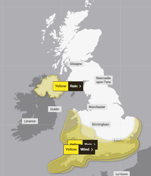
Overview of weather warnings
Monday 30 October 2023 12:10 , Athena Stavrou
The Met Office has summarised all weather warnings in place until Thursday evening.
⚠️ A number of severe weather warnings are in place this week ahead of #StormCiarán due to arrive on Wednesday night.
Here's a summary:
🟠 An Amber warning for RAIN is in place for eastern Northern Ireland from 2100 Monday – 0900 Tuesday
⚠️ A Yellow warning for RAIN covers…— Met Office (@metoffice) October 30, 2023
Heavy rain expected as “nasty storm” builds up
Monday 30 October 2023 11:40 , Athena Stavrou
The UK is braced for another deluge of rain over the next few days as wet and windy weather is expected to build up to a “nasty storm” later in the week.
On Monday, the worst of the weather is likely to hit the south coast of England, much of Wales and parts of Northern Ireland.
Marco Petagna, a Met Office meteorologist, said: “We’ve had various warnings in force across the UK over the last few days and there are plenty more being issued for the next couple of days.
“The main focus in the next day or two is towards the east of Scotland and north-east England where there is a yellow rain warning until 3am.
“There will be persistent rain up there and then the focus for heavy showers will be across parts of southern and south eastern England and south Wales as well parts of Northern Ireland with some heavy and sudden showers as well.”
He said that Tuesday was expected to be still unsettled but quieter before heavy winds and longer spells of rain develop on Wednesday night into Thursday as Storm Ciaran arrives.
He said: “There are possible gusts of 80 to 90 miles an hour in some exposed southern areas. It’s probably quite a nasty storm this one.”
Pictures: Weather chaos over the weekend
Monday 30 October 2023 11:09 , Athena Stavrou
Ahead of Storm Ciarán’s arrival in the UK on Wednesday, Britons had a wet weekend with extreme flooding already being seen in some areas.

Suspected flooding in Chester
Monday 30 October 2023 21:24 , Lydia Patrick
There are reports of flooding in Chester asthe North West is still recovering from Storm Babet’s destruction.
A small business reported their home office had been flooded on Facebook whilst a local bus service said there service had been disrupted due to flood waters.
The Independent have been unable to verify these reports.
#Chester.....a flood on Christleton Road is causing delays to our services in and out of town,apologies for the inconvenience
— Stagecoach Merseyside & South Lancashire (@StagecoachMCSL) October 30, 2023
Met Office issues new danger to life warning for today
Monday 30 October 2023 10:29 , Athena Stavrou
The Met Office has issued a new amber weather warning for rain today.
The warning will be in place in Northern Ireland from 9pm tonight until 9am on Tuesday and comes with a “danger to life” warning due to fast-flowing or deep floodwater.
They also say communities in the region could be “completely cut off” for “several days” by floodwater and warn of power cuts and loss of gas, water, or mobile phone services.
Flood warnings in place
Monday 30 October 2023 10:12 , Athena Stavrou
Although Storm Ciarán is not set to arrive in the UK until Wednesday night, the UK is already under a staggering number of flood warnings and alerts.
In England, 69 flood warnings and 173 flood alerts are currently in place spanning almost the entirety of the country.
In Scotland, five flood warnings and five flood alerts are in place in central Scotland as well as in Edinburgh. Meanwhile, in Wales, one flood warning and 14 flood alerts have been issued in the south and southwest of the country.
UK’s five day weather forecast
Monday 30 October 2023 10:10 , Athena Stavrou
Here’s the UK’s five day weather forecast, according to the Met Office:
Today:
Monday will be cloudy with patchy rain across eastern Scotland and northern England. Some sunshine elsewhere, but with heavy showers, some thundery, becoming more widespread from the south and west and across Northern Ireland during the afternoon.
Tonight:
Mostly dry and chilly across the north with isolated showers near coasts. Heavy showers continuing to affect southwest England, Wales and Northern Ireland. Elsewhere clear spells and patchy fog developing.
Tuesday:
Dry with sunny spells across the north. Elsewhere variable amounts of cloud with rain or showers especially across the southwest and Northern Ireland. Persistent rain arriving from the southwest later.
Outlook for Wednesday to Friday:
Wednesday will see showers or longer spells of rain moving northeast, and generally becoming windy. Storm Ciarán arriving later Wednesday bringing a spell of heavy rain and gales forces winds.
Amber ‘danger to life’ warning now in place
Monday 30 October 2023 21:35 , Lydia Patrick
The Met Office issued an amber “danger to life” warning at 9pm today, ahead of Storm Ciarán’s arrival on Wednesday evening.
The forecaster’s latest warning for rain will be in place in Northern Ireland until 9am on Tuesday.
Meet the man Storm Ciarán is named after
Monday 30 October 2023 09:38 , Athena Stavrou
The Met Office, Ireland’s Met Éirean and Royal Netherlands Meteorological Institute (KNMI) work together to compile the list before the start of the season which runs from September to August.
This year, some of them have been chosen in honour of real-life weather experts - one of them being Ciarán Fearon.
Mr Fearon is a senior engineer in the Emergency Planning Unit for Irelands Department for Infrastructure.
He tells us more about himself below:
🎥Those who work to keep people safe in times of severe weather have been recognised in the new storm names for the 2023/24 season.@Deptinfra’s Ciarán Fearon, a senior engineer in the Emergency Planning Unit has made the list.
Ciarán tells us more in the video:@metoffice pic.twitter.com/fJbQdOXPfT— Department for Infrastructure (@deptinfra) September 1, 2023
Watch: Storm Ciarán’s predicted path across the Atlantic
Monday 30 October 2023 09:11 , Athena Stavrou
Storm Ciarán is set to arrive in Britain on Wednesday night, with it’s full effects to be seen by many Britons on Thursday.
Strong winds carried by the jet stream will cross the Atlantic this week, this area will develop into Storm Ciarán on it’s journey.
Strong winds carried by the jet stream will cross the Atlantic this week, moving from the Northeastern US to Western Europe. This area will develop into Storm #Ciarán, which will bring strong winds and rain to France and southern UK midweek. pic.twitter.com/n6EvXB0JW0
— Zoom Earth (@zoom_earth) October 29, 2023
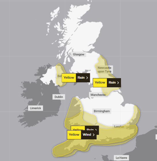
What weather warnings are in place today?
Monday 30 October 2023 08:40 , Athena Stavrou
Four yellow weather warnings are in place on Monday for both wind and rain.
In Wales, a yellow weather warning for rain, which began on Sunday, remains in place until 9am on Monday.
In London and southeastern England, a yellow weather warning for rain began at 12am on Monday and will remain in place until 6pm.
The Met Office warns that there is a chance of power cuts and flooding in the region.
Meanwhile, there are two yellow weather warnings in place for rain in Northern Ireland. The first began at 12am on Monday and will remain in place until noon then later in the day another yellow weather warning will come into place for rain at 4pm.
The Met Office says flooding of a few homes and businesses in the region is “likely”
Watch: Water rises above windows of London pub
Monday 30 October 2023 08:21 , Athena Stavrou
A video from a riverside London pub shows the water level rising above the windows following a weekend of wet weather.
The pub, which is thought to be The Bull’s Head in Chiswick, posted the video to X on Sunday to show the “high tide”.
Elsewhere, a shopping centre had to be evacuated in Hastings following flooding and pictures showed flooding in a holiday park in Bognor Regis.
Today’s forecast
Monday 30 October 2023 08:03 , Athena Stavrou
As Briton’s are expecting a wet and windy week ahead, here’s the Monday’s forecast from the Met Office.
Monday will be cloudy with patchy rain across eastern Scotland and northern England.
Some sunshine elsewhere, but with heavy showers, some thundery, becoming more widespread from the south and west and across Northern Ireland during the afternoon.
Some sunny spells to start Monday though showers affecting southern and western areas, heavy and even thundery in places ⛈️ pic.twitter.com/YPLewZEThA
— Met Office (@metoffice) October 29, 2023
Scotland rail service update
Monday 30 October 2023 07:40 , Athena Stavrou
ScotRail services will be returning to normal on Monday following disruption during a weekend of heavy rain with weather warnings.
Some services were suspended and speed restrictions were in place while the Met Office yellow alert was in force in much of eastern and north-east Scotland. The warning expired on Sunday and ScotRail said that speed restrictions put in place across the region as a safety precaution have now been removed across most of the network.
ScotRail said that work is underway to ensure that services run as normal on Monday, though it warned passengers that there may be some remaining alternations first thing in the morning as some trains have been left out of place.

There are currently no weather warnings in place for Scotland later this week when Storm Ciarán hits, but areas in southern England have been warned by the Met Office to expect delays and cancellations to transport services.
David Simpson, ScotRail service delivery director, said: “The vast majority of services will operate as normal on Monday, and we look forward to welcoming passengers to take advantage of our off-peak all day trial.
“Customers are advised to check before travelling by visiting the ScotRail website, app, or social media channels.”
Speed restrictions will remain in place until early on Monday on the Kyle line (Inverness to Kyle of Lochalsh).
LNER said there will be no services running from Edinburgh to Aberdeen, or from Aberdeen to Edinburgh, until Monday due to the weather.
Good morning- here’s your latest update
Monday 30 October 2023 07:25 , Athena Stavrou
Good morning and welcome to the blog. Here’s the latest weather information as the UK prepares for another week of extreme weather.
The Met Office has named the third storm of the season as it’s set to bring “strong winds and heavy rain” to the UK from Thursday.
Ciarán is due to bring gusts of 80mph winds to areas along the south coast of England, with a small risk of some more exposed areas seeing wind speeds of up to 90mph. Meanwhile, up to 60mm of rain is expected to fall in some areas.
However even before Ciarán officially hits our shores, the UK will see wet and windy weather all week. Yellow weather warnings for rain are currently in place across southeastern England, south Wales and Northern Ireland and some are set to remain in place until Thursday evening.
Storm Ciaran: How and why storms get their names
Monday 30 October 2023 07:00 , Stuti Mishra
The UK is braced for downpours and blustering gales once again with a new storm just days after Storm Babet battered large parts of the country.
This is the third named storm of the season, hence starts with the letter C.
Here's why storms are named and the new changes the UK Met Office has made in its process for naming the storm in 2023/24 season.
Read more:
From Babet to Walid: How and why storms get their names
Mapped: Storm Ciarán’s path across the UK
Monday 30 October 2023 06:00 , Athena Stavrou
Here is the predicted path Storm Ciarán is set to take as it sweeps across the UK from Wednesday night.

72 flood warnings in place ahead of Storm Ciaran
Monday 30 October 2023 05:30 , Stuti Mishra
The Environment Agency has issued 72 flood warnings as the latest band of bad weather approaches the UK.
New storm warnings are in place from Wednesday night, and the weather front has been named Storm Ciaran.
"Heavy and persistent rain will fall on to already saturated ground bringing a risk of further impacts such as flooding in areas that are already struggling to clean up from the heavy rainfall we have seen over the last week or so," Met Office deputy chief meteorologist Chris Almond said.
"Flooding of low-lying coastal roads is also possible and people must avoid driving through flood water, as just 30cm of flowing water is enough to move your car," said Kate Marks, flood duty manager at the Environment Agency.
“People should check their flood risk, sign up for free flood warnings and keep up to date with the latest situation at https://www.gov.uk/check-if-youre-at-risk-of-flooding and follow @EnvAgency on X, formerly known as Twitter, for the latest flood updates.”
Advice for travelling in storms
Monday 30 October 2023 05:00 , Athena Stavrou
With Storm Ciarán set to batter the UK on Thursday, here’s the Met Office’s advice for travelling in a storm:
If heavy downpours are expected, avoid starting your journey until it clears.
If you can, choose main roads, where you are less likely to be exposed to fallen branches and debris and flooding.
Use dipped headlights if visibility is seriously reduced.
If the road is flooded, turn around and find another route. The number one cause of death during flooding is driving through flood water, so the safest advice is turn around, don’t drown.
Keep an eye out for gaps between trees, buildings or bridges over a river or railway
Flood water also contains hidden hazards which can damage your car, and just an egg-cupful of water sucked into your car’s engine will lead to severe damage.
Gusts of wind can unsettle vehicles – grip your steering wheel firmly with both hands.
Remember to give vulnerable road users including cyclists, motorcyclists and pedestrians more room than usual - they are more likely to be blown around by side winds

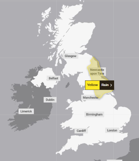
Weather forecast for Monday
Monday 30 October 2023 04:30 , Stuti Mishra
The week is set to start on an unsettled note with clouds and patchy rain predicted for today for large parts of Scotland and Northern England.
The Met Office forecast says "some sunshine" can be expected in the south early on but later heavy showers, some thundery, are set to become more widespread from the south and west.
Four yellow weather warnings are in place today for heavy rain covering parts of Northern Ireland and southern and southeast England.
A yellow warning which began from midnight on Monday covering Portsmouth, Brighton, Hastings and Dover is in place until 12pm.
Another yellow warning covers parts of southwest Wales and is in place until 9am on Monday.
Eastern parts of Northern Ireland are under two yellow warnings today, one in place until noon and the second starting at 4pm and extending on until Tuesday.
⚠️ Yellow weather warning issued ⚠️
Frequent heavy showers across parts of Northern Ireland
Monday 00:00 - 12:00
Latest info 👉 https://t.co/QwDLMfS950
Stay #WeatherAware pic.twitter.com/fnfqYn39xH— Met Office (@metoffice) October 29, 2023
Amber ‘danger to life’ warning in place
Monday 30 October 2023 21:32 , Lydia Patrick
The Met Office issued an amber “danger to life” warning at 9pm, ahead of Storm Ciarán’s arrival on Wednesday evening.
The forecaster’s latest warning for rain will be in place in Northern Ireland until 9am on tomorrow.
#StormCiarán will bring disruptive wind and rain to the UK from Wednesday evening and throughout Thursday.
Watch our latest Week Ahead forecast to find out more ⤵️ pic.twitter.com/DzmvvQV5Iv— Met Office (@metoffice) October 30, 2023

