Wednesday's updates: Tropical Storm Nicole news and updates from Wednesday
It's been just six weeks since Hurricane Ian caused mass destruction on Florida's Southwest Coast.
Despite the calendar showing hurricane season is nearing its Nov. 30 end, Florida's East Coast finds itself in the path of a rare November hurricane.
Check back with floridatoday.com throughout the day for all the latest updates.
And if you have a tip that would be helpful to your friends and neighbors here on the Space Coast, email Tim Walters at twalters@floridatoday.com.
Follow real-time updates below (manual refresh required):
6:10 a.m. Thursday
We have created a new blog for Thursday. For the latest information on Tropical Storm Nicole in Brevard County, click on the link below:
Thursday updates: Hurricane Nicole and its overnight impacts as Thursday arrives
10:10 p.m.: A note to all of our readers
As we approach the overnight hours, we at FLORIDA TODAY would like to wish the best to all our Brevard County families, and those beyond.
Winds around the county have picked up, our beaches have been battered and power has been knocked out in locales from Indialantic to Cocoa Village, yet the storm's eye still hasn't made landfall.
We are here to serve you and we thank you for making us your go-to source for news and information on the storm. From our amazing photo staff to our talented reporters, we are your neighbors and we love Brevard as much as you do.
We will continue to update as needed in the overnight hours. Our plan is to fully pick up at 6 a.m. Thank you for staying with us as we bring you the sights and sounds of your community as Hurricane Nicole passes through.
— Tim Walters, FLORIDA TODAY, Merritt Island High graduate and resident of West Viera
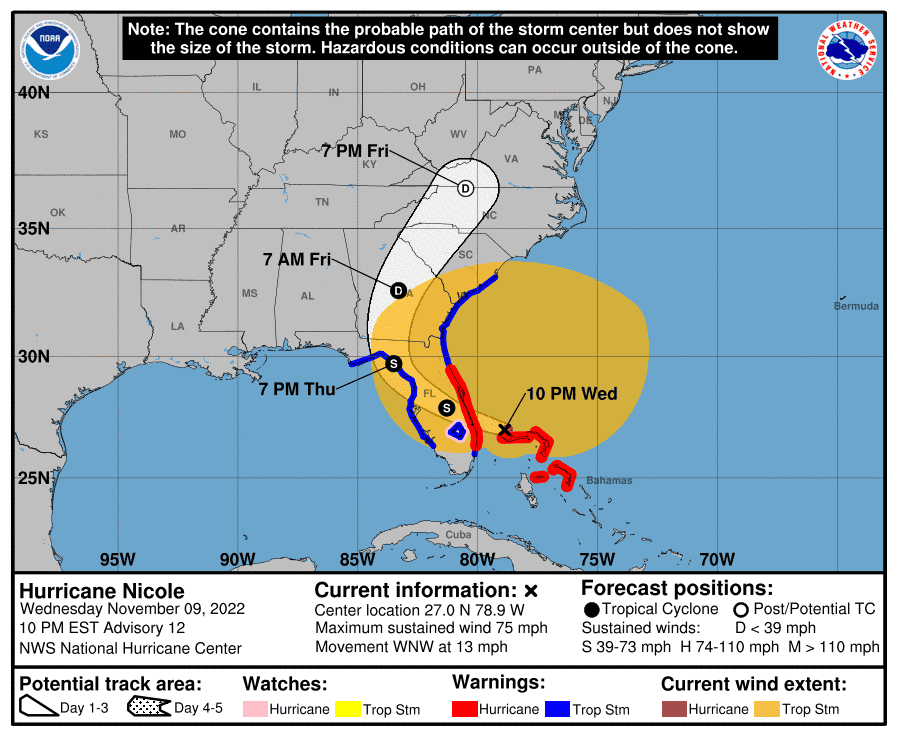
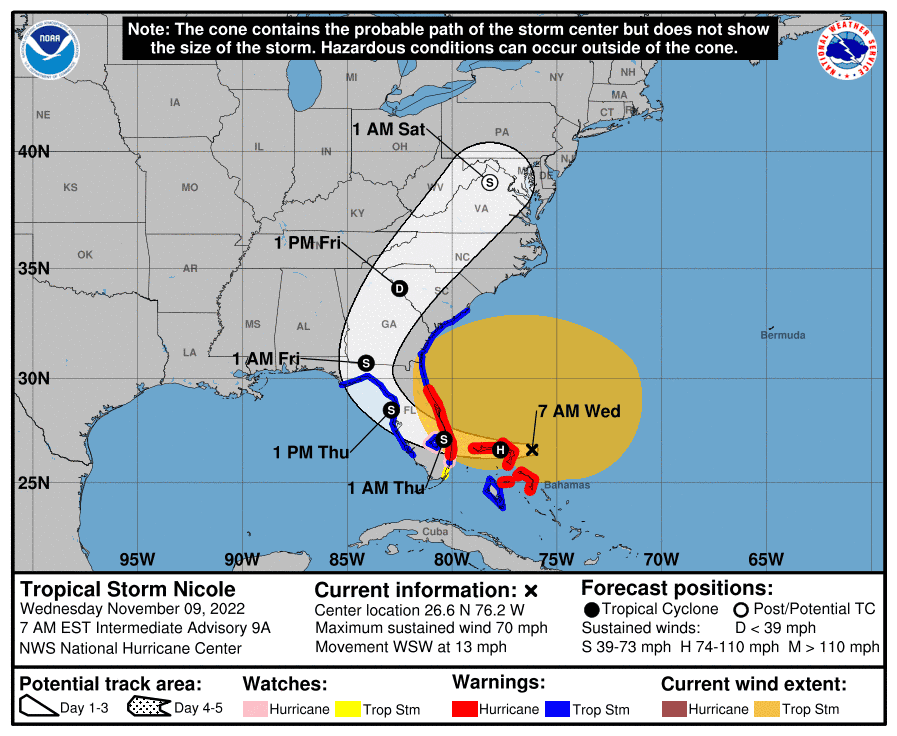
10 p.m.: Latest Hurricane Nicole track
As of 10 p.m., Hurricane Nicole was approaching its Florida landfall. The eye of the storm is moving away from the Bahamas and into the open waters of the Atlantic. It's moving WNW at 13 mph.
Maximum sustained winds remain at 75 mph.
Most of Florida's East coast from Miami to St. Augustine remain under a hurricane warning.
The system is expected to move through the state quickly Thursday.
6:21 p.m.: Nicole is now a hurricane
Nicole has officially been named a hurricane. Sustained winds now exceed 75 mph.
Read below for the latest on the storm.
Category 1: Hurricane Nicole forms as Space Coast residents evacuate barrier islands, make final preparations
5:24 p.m.: Shelters sparsely populated
Few residents have decided to seek shelters from Nicole. As of late afternoon, the count is 170 people and 12 pets across four available shelters.
5:05 p.m.: DoorDash suspends food delivery in Brevard
DoorDash has suspended delivery in Brevard County as of 5 p.m. Wednesday as Tropical Storm Nicole approaches, according to a press release.
“The safety of Dashers, merchants and customers is our top priority,” said Julian Crowley, spokesperson for the food delivery service.
DoorDash officials will monitor weather conditions and follow the guidance of local authorities before resuming operations, according to the release.
4:31 p.m.: Check here to see where power is out
As the storm nears Florida, people around the area might lose power.
To keep up with the latest on where power is out, click on this link below.
Power out map: See Brevard County power outage map as Tropical Storm Nicole impacts Florida
4:23 p.m.: Parrish Medical Center initiates lockdown
The National Weather Service predicts tropical-storm-force winds affecting Brevard County by 7 p.m. In response, Parrish Medical Center will initiate a partial lock-down of the hospital beginning at 6 p.m. in accordance with its Hurricane/Tropical Storm emergency response protocols.
Public access to the hospital will be limited to persons requiring emergency medical attention. In the interest of public safety, general visitation will not be permitted after 6 p.m.
However, hospitalized patients are permitted one partner in care to remain with them until the storm event is cleared. The partial lock-down status will remain in effect until further notice.
In addition, elective procedures have been canceled for Thursday, but will resume normal operations on Friday.
Reminder that the hospital is not a shelter. For shelter information, visit brevardfl.gov/EmergencyManagement.
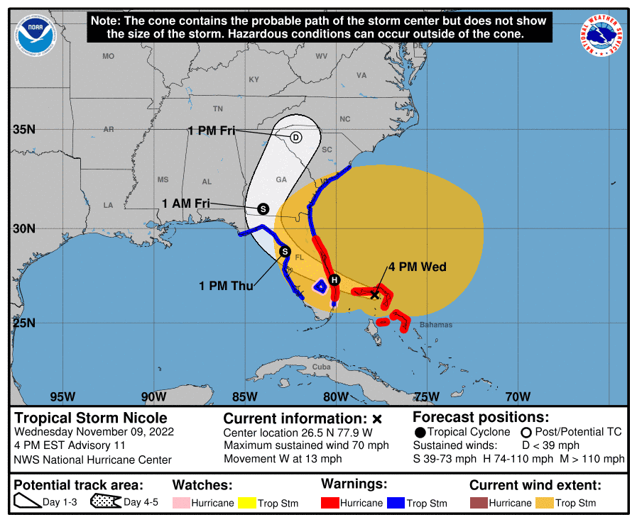
4:18 p.m.: Latest track of Nicole
As of 4 p.m., Nicole remained a Tropical Storm with sustained winds of 70 mph.
The eye is now due west of Great Abaco in the Bahamas, an area that was decimated by Hurricane Dorian in 2019. It is moving over Grand Bahama.
The storm is expected to strengthen as it moves away from land and over the warm Atlantic waters as the night moves on.
4:14 p.m.: Space Force Base goes to HURCON I
Space Launch Delta 45 officials initiated HURCON I at Patrick Space Force Base and Cape Canaveral Space Force Station.
Non-essential base facilities are closed at this time.
Hurricane Condition I indicates the possible arrival of winds exceeding 50 knots (57.5 mph) within 12 hours.
3:39 p.m.: Storm surge will be biggest issue
The beaches of Brevard have already taken a pounding, and the worst of it is yet to come.
Here's what to know about what the storm surge might do as the storm passes.
Beaches will take a beating: Storm surge could be Nicole's most damaging impact to Brevard
3:12 p.m.: These Cocoa-area stores closing early
Last-minute hurricane prep update for Cocoa shoppers: Aldi at 2609 Clearlake Road has closed in advance of Tropical Storm Nicole.
Walmart at 2700 Clearlake Road in Cocoa was still open at 2 p.m., with a packed parking lot, but the following message is posted on the store’s Facebook page:
“Due to the imminent landfall of Hurricane Nicole, our store is closing temporarily at 5 p.m. today. We will be closely monitoring the situation and will reopen as soon as it is safe for our associates and the community. Stay safe.”
In the same area of Cocoa, Publix closed at noon.
3:05 p.m.: Nicole's winds battering Satellite beaches
Dune crossovers in the Satellite Beach have been damaged up and down Satellite Beach. Officials have encouraged residents and visitors to avoid the beach. Hear from the Satellite Beach city manager.
Wind, surf damage: All 16 Satellite Beach public dune crossovers damaged, shut down by Tropical Storm Nicole
3 p.m.: Watch the KSC live cam
Nicole: Watch live from NASA's Kennedy Space Center as storm approaches Florida
2:50 p.m.: Ossorio in Cocoa Village offers a warm meal and companionship before the storm
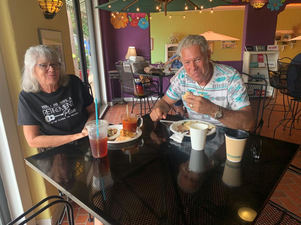
"Thanks for being open," Gino Butto of Merritt Island said as he and his wife Robin walked into Ossorio Cafe & Bakery in Cocoa Village.
The corner cafe traditionally remains open the day before a hurricane is predicted to impact the Space Coast, giving those in need of a hot meal and companionship before lockdown a respite from storm prep.
Ossorio closed at 2 p.m., but at noon, the dining room filled up. As rain fell from gray skies, the wood-fired oven in the kitchen gave the restaurant the cozy feel of a ski lodge.
Managing partner Emma Kirkpatrick said lunch before a storm has become tradition for some people.
The Buttos are regulars on Saturday mornings, but this was their first pre-hurricane visit.
"It's going to be a new tradition," Gino said.
He recently retired from a job that required him to go into work while the rest of the family evacuated.
They booked a dog-friendly hotel, just in case, but canceled it this morning when they saw the latest storm track.
Kirkpatrick said she always closes the restaurant before tropical storm-force winds reach the area. She wants her staff to get home safely. Ossorio will be closed Thursday, with plans to open at 8 a.m. Friday unless there's significant damage.
1:50 p.m.: Southern Brevard communities on alert for winds
Manufactured homes communities in Barefoot Bay and Micco are prepping for possible high winds from Tropical Storm Nicole. Read more about it below:
Manufactured homes: Barefoot Bay, Micco residents buckle down for Tropical Storm Nicole
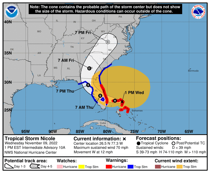
1 p.m.: Latest track just released:
As of 1 p.m., Nicole remained a tropical storm, with winds sustained at 70 mph.
The eye of the storm is over the northern Bahamas and it continues to track toward the Stuart/Martin County area.
Brevard County continues to see effects on its beaches as massive erosion has already occurred.
12:58 p.m.: Tip from a neighbor
Dick Hynes, who lives in Cocoa Village, just sent us this bit of helpful wisdom:
"Place a pool “noodle” between the sliding glass doors and the accordion shutters to keep water from blowing up under the accordions!"
Great idea. Thanks Dick!
12:37 p.m. DeSantis: Martin County looks to be site of landfall
Tropical storm Nicole is expected to make landfall in Martin County as a Category One hurricane and move through the state into the Gulf of Mexico before making landfall again in Florida’s Big Bend region, Gov. Ron DeSantis told reporters Wednesday.
“The combined winds and storm surge will contribute to continued beach erosion in areas that have already seen erosion from Hurricane Ian,” said DeSantis in describing the large storm. “We expect the impact to stretch far beyond the center track, including tropical storm force winds as far north as Jacksonville.”
He said he expect to see heavy rains, the potential for flash flooding and three to five feet of storm surge in some areas, noting that Palm Beach, Martin St. Lucie, Indian River, Brevard and Volusia counties are currently under a hurricane warning.
People in impacted areas should pay close attention as the storm progresses and that they do not need to evacuate hundreds of miles away from the storm but instead need to move to safer areas inland, said DeSantis, who said Floridians in the storm’s path should expect to see “power outages when you're having these gusty conditions.”
He said about 16,000 linemen are prepared to start power restoration efforts and that the Florida National Guard has activated 600 guardsmen, along with seven urban search and rescue teams on standby.
He added that 15 shelters are opening today along the east coast of Florida and that 17 school districts were closed or dismissed early Wednesday ahead of the storm. At least 23 school districts will be closed on Thursday.
— Sergio Bustos, USA TODAY Network-Florida
12:28 p.m.: Artemis delayed; will it topple over??
Prior to Hurricane Ian, the 332-foot tall multi-billion dollar rocket was rolled back to the Vehicle Assembly Building.
For Tropical Storm Nicole, which is expcted to become a Category 1 hurricane, they are leaving it on the pad.
But they are also delaying the next launch attempt.
When might it launch and could it fall over from heavy winds? Click below to find out:
Still not flying: NASA's Artemis I is delayed again as the moon rocket is left to endure Tropical Storm Nicole
12:24 p.m. Getting ready for Nicole
In southern Brevard in Micco, people are preparing for the storm. We speak with one shop owner who is prepping their store.
Manufactured homes: Barefoot Bay, Micco residents buckle down for Tropical Storm Nicole
11:56 a.m.: Palm Bay under State of Emergency
Palm Bay declared a state of emergency Tuesday afternoon. For updates, visit this link: https://www.palmbayflorida.org/Home/Com
It says, in part:
"A local state of emergency is declared in advance of a potential disaster and enables the City of Palm Bay to expedite procurement processes to obtain critical goods and services and to readily seek response or recovery assistance from the state of Florida to address municipal needs. The city will remain closed through Thursday. City facilities are scheduled to be closed on Friday, Nov. 11, in observance of Veterans Day.
11:41 a.m.: Brevard leadership speaks
Sheriff Ivey and Brevard Emergency Management officials give the latest update on Nicole. Watch below:
11:38 a.m.: Officials: Don't take this storm lightly
Sure, it's been a breezy and grey morning on the Space Coast, but aside from some erosion, we really haven't seen much from Nicole.
Don't be fooled. The storm's eye is still near the Bahamas and the worst will come overnight.
Brevard officials are urging you to be prepared. Read their most recent warning below:
Worst is yet to come: Brevard County officials urge residents to continue preparing for coming storm
10:55 a.m.: Brevard Publix's set to close Wednesday
Publix has just released this important info regarding store closures:
"Stores in the following counties will close at noon Wednesday, Nov. 9. We anticipate the stores in the counties listed below to reopen on Thursday, Nov. 10, at 9 a.m.
Brevard
Indian River
Okeechobee: Only store #118 (located at 3551 US Highway 441 S, Okeechobee) will close at noon today (11/9)
St. Lucie County (anticipated to reopen on Thursday, Nov. 10 at 7 a.m)
Hours may be adjusted and the status of individual stores are subject to change based on the storm track and projected impacts.
For the most up-to-date information regarding store status, please visit www.publix.com/storm.
10:50 a.m.: Port Canaveral has closed
Port Canaveral closed Wednesday morning, as Tropical Storm Nicole approaches Florida's east coast.
Jacksonville-based U.S. Coast Guard Cmdr. J.D. Rose, who is the acting captain of the port, on Tuesday morning put Port Canaveral at "Port Condition Zulu."
That means sustained gale force winds are predicted within 12 hours.
For more on cruise ships, the gambling boat and smaller boats not allowed to shelter in the Port, read below:
Port closed: Coast Guard orders Port Canaveral closed because of Tropical Storm Nicole
10:42 a.m.: Fact Check: Space Coast bridges open
rumors abound, but, no, Brevard’s bridges and causeways are not closing. They will remain open through the storm, confirmed Sheriff Wayne Ivey in a briefing Tuesday.
“The bridges are not being closed in any capacity,” he said. “Our bridges will be open for traffic coming and going. But we want you to be careful.”
10:40 a.m.: Melbourne declares State of Emergency
The City of Melbourne has also declared a state of emergency.
A statement released said the "imminent approach of Tropical Storm Nicole, along with anticipated heavy rainfall, high tides, gale-force or greater winds, and flooding, poses a serious threat to the health, safety, and welfare the people and property of City of Melbourne, Florida, and that a state of local emergency is declared, effective as of 12 p.m. on Nov. 9, 2022 for the areas of the City of Melbourne.
It will "remain in effect for seven days unless extended or rescinded in accordance with Section 18-23(e) of Melbourne City Code.
10:25 a.m.: Cocoa declares State of Emergency
Cocoa City Council declared a local State of Emergency beginning at 8 a.m. Wednesday, Nov. 9, for the City of Cocoa.
City facilities will be closed Wednesday and Thursday. City facilities will remain closed Friday in observance of Veterans Day and plans are to re-open on Monday. Essential personnel are preparing and responding as needed.
The Cocoa City Council meeting scheduled for Wednesday has been canceled. All items on this agenda will be moved to the special meeting scheduled for Tuesday, Nov. 29.
Sand piles have been placed throughout the City to allow residents to fill their own sand bags at the following locations:
W Railroad Avenue @ Rosa Jones
School Street near N. Wilson
London Blvd neat SR 524
Michigan Road – Behind Cocoa Jr/Sr High
Updated information related to the storm can be found on the City’s social media pages and website:
Facebook: https://www.facebook.com/CityofCocoa/
Twitter: https://twitter.com/CityofCocoa
Website: www.CocoaFL.gov/hurricane
10:11 a.m.: Get your Facebook fix
We've also got a Facebook group where you can ask your questions about the storm and keep up to date on the latest Nicole information: https://www.facebook.com/groups/brevard.hurricane.watch
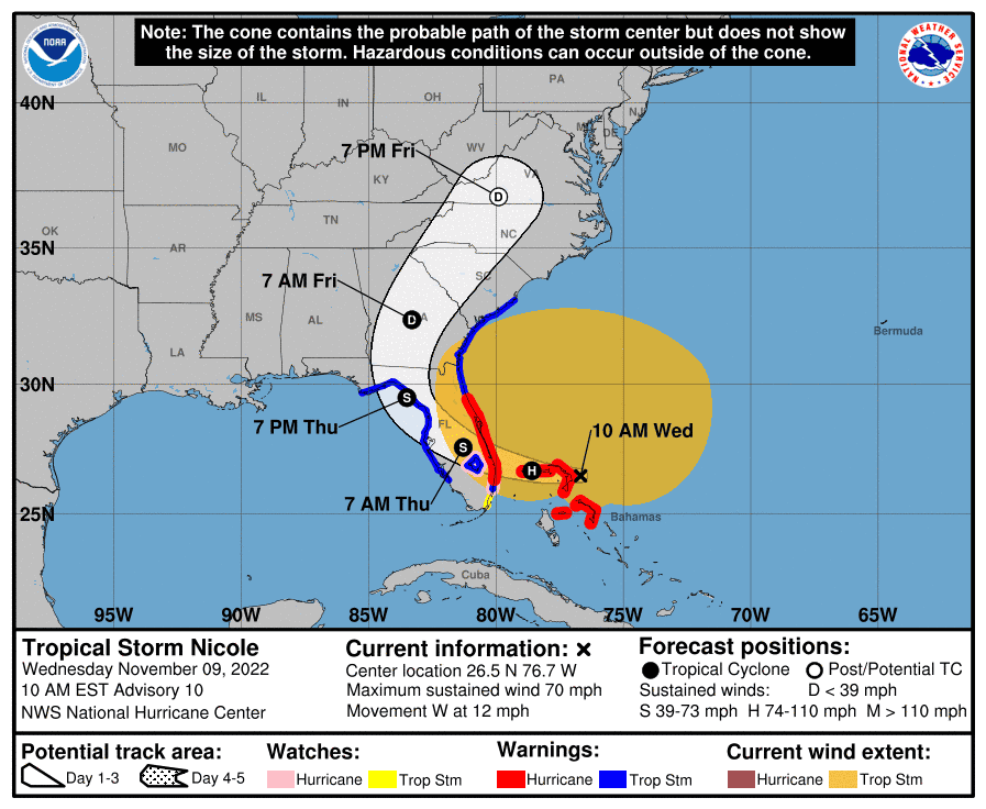
10:05 a.m.: New track, little has changed
Very little has changed track-wise from 7 a.m. to 10 a.m. The storm's eye has inched closer to the Bahamas and it continues to show maximum sustained winds at 70 mph, just 5 mph less than a Category 1 hurricane.
9:45 a.m.: Click through these map zoom-ins to see your surge risk during Nicole
Environmental reporter Jim Waymer created these surge-risk maps for Brevard County, using data from Geographic Information data derived from National Hurricane Center's Sea, Lake and Overland Surges from Hurricanes (SLOSH) model runs for basins throughout Florida.
The purple highlighted in bright blue is where storm surge could flood in a Category 1 hurricane. The dark green is at surge risk in Category 2 storm. Light green is at risk in Category 3 storm. The lighter orange is Category 4 surge-prone areas, and the darkest orange is Category 5 surge areas.
These zones were created for the Florida Statewide Regional Evacuation Update Study.
(Mapping by Jim Waymer, of data from Florida Regional Planning Council's and Florida Division of Emergency Management: www.floridadisaster.org/res)
Your risk assessment: Satellite images show storm surge risk for Brevard from hurricanes
9:30 a.m.: Shelters are open around Brevard
Brevard County officials opened a Tropical Storm Nicole shelter at 9 a.m. at the South Mainland Community Center in Micco. No residents had checked in by 9:25 p.m., but staffers expect a good number to arrive this afternoon.
— Rick Neale, FLORIDA TODAY
9:02 a.m.: Need something to watch? Web cam it!
We have web cams across the east coast of Florida for you to check out. Want to see the conditions for yourself? Check this out.
Seeing is believing: See traffic and beach conditions in Brevard area as Nicole nears Florida
8:57 a.m.Tropical Storm soon to be hurricane
At last check, Nicole's winds were 70 mph, just below a Category 1 hurricane. At next check, Nicole could become a hurricane.
Space Coast residents, especially those in coastal areas, are preparing.
Soon to be hurricane: Nicole to intensify into hurricane as Space Coast residents evacuate barrier islands, make final preparations
8:50 a.m.: Cocoa Beach pier volleyball courts under water
As high tide nears Wednesday morning, the Atlantic Ocean had swallowed the volleyball courts by the Westgate Pier in Cocoa Beach. With the storm still more than 12 hours from landfall, it's an ominous sign of what is to come for Space Coast beaches and oceanfront property.
8:05 a.m.: NASA braces for impact
The 322-foot tall Artemis rocket is sitting on launch pad 39A as Nicole approaches.
It won't topple over, right?
Here's what to know from NASA and the Space Force.
Running out of space: As Nicole strengthens to potential hurricane, NASA and Space Force prep for storm surge
8 a.m.: One big blob
Tropical Storm Nicole's winds extend 460 miles from the center of circulation. To put that into perspective, it's roughly 350 miles from Miami to Jacksonville.
Read more at the link below.
The latest info: Tropical Storm Nicole winds up to 70 mph. Track storm, possible impacts in Brevard County
Latest track has storm making landfall further south
As of 7 a.m., the National Hurricane Center's latest model shows the eye of Tropical Storm Nicole making landfall just east of Lake Okeechobee. The strongest weather is expected to be on the north side of the storm, which means Brevard County should expect strong winds, potential flooding and massive beach erosion.
Nicole is expcted to strengthen to a hurricane later Wednesday and make landfall overnight. It will quickly move through the state and exit overnight Thursday into Friday.
By Sunday, expect cooler temperatures, with highs in the mid to upper 70s.
Brevard teams in FHSAA sports playoffs rescheduled
Three Friday night high school football games, Viera's state championship volleyball game as well as state golf and swimming and diving have been rescheduled.
Find up-to-date information at this link.
— Brian McCallum, FLORIDA TODAY
KSC Visitor Complex closed Thursday
Kennedy Space Center Visitor Complex will be closed beginning Wednesday, Nov. 9, at the recommendation of the Brevard County Emergency Management Office. Severe weather is expected on the Central Florida coast due to Tropical Storm Nicole.
The visitor complex expects to reopen on Friday after a thorough assessment of the property has been complete.
During the closure, guests will not be permitted onto visitor complex grounds.
For the latest updates please continue to visit KennedySpaceCenter.com or Facebook and Twitter (@ExploreSpaceKSC).
— Tim Walters, FLORIDA TODAY
Florida Tech athletic events canceled
This week's scheduled contests that are canceled due to Nicole include volleyball playing at Lynn and men's and women's swimming hosting Keiser on Wednesday, along with women's basketball vs. Fort Valley State originally scheduled for Friday and Saturday.
All updates to athletics schedules will be updated on FloridaTechAthletics.com
For the latest news, updates and information on Florida Tech Athletics, visit FloridaTechSports.com.
Fans can also stay up-to-date on the latest Panthers news by following Florida Tech Athletics on Facebook, Twitter, Instagram and YouTube.
— Tim Walters, FLORIDA TODAY
This article originally appeared on Florida Today: Wednesday updates: Tropical Storm Nicole wreaks havoc on brevard

