Month's worth of rain to fall in Texas, Louisiana


A round of heavy rain aiming for the south-central United States will bring some much-needed rain to the region through the end of the week, but it can also be too much of a good thing, AccuWeather meteorologists warn.
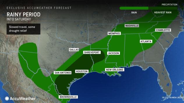
The downpours will impact over a half-dozen states through Saturday. The heaviest rain will fall over the areas that need it the most, from southern and eastern Texas into portions of Louisiana, where severe drought conditions are present.
 |
The wet weather will represent a marked turnaround from the recent pattern over the region, where dry conditions and near-record warmth have been the norm for the better part of the last week. Looking into next week, there can even be additional rain to help cut into the deficits seen in this part of the country, as well as help tackle recent bouts of disruptive dense fog and wildfires.
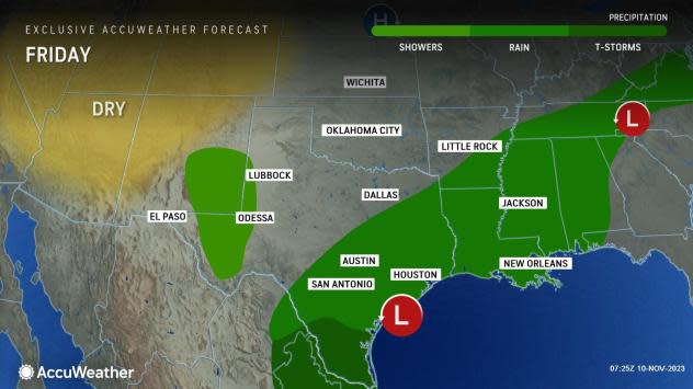
Following a dry Wednesday, the rain expanded dramatically on Thursday from across several hundred miles along the Texas border with Mexico to a portion of the lower Mississippi River, according to AccuWeather forecasters.
While most of the moisture leading to the rain originates from the Pacific Ocean, moisture from the Gulf of Mexico will eventually play a role, along with a slow-moving cold front draped across the region.
From Friday through Saturday, the rain will expand into much of the Texas coast, as well as neighboring portions of western Louisiana. Most of this region will end up taking the brunt of the downpours through the start of the weekend, and rainfall amounts of 1 to 3 inches will be common, including in Austin, Corpus Christi, Houston and San Antonio, Texas, and Shreveport, Louisiana.
"It is not out of the question that up to 6 inches of rain can fall somewhere, especially in southeastern Texas," said AccuWeather Senior Meteorologist Dan Pydynowski. "This means that some areas could quickly go from drought to having to worry about localized street and highway flooding."
 |
The amount of rain expected from this system will rival or eclipse the historical average for the entire month of November. For example, Austin averages 2.08 inches of rain for the month while Brownsville averages 1.76 inches in November. Rainfall amounts through the weekend can easily exceed those levels in both cities.
Yesterday alone, locations across southeastern Texas saw rainfall totals generally ranging from half an inch to an inch, with isolated reports of an inch and a half. The highest total of 1.51 inches was reported in Crockett, TX.
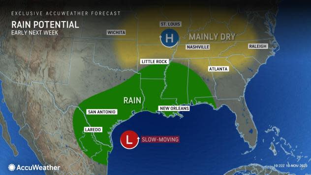
Downpours will remain focused along the front as it stalls near the Gulf Coast into this weekend and even next week, only adding to some hefty rainfall totals in area rain gauges.
Accompanying the moisture will also be a dramatic cooldown, a welcome sight for some residents who are growing weary of temperature readings in the 80s to near 90 degrees that have lasted deep into the autumn months.
All across the south-central U.S., temperatures have either recently approached, tied or exceeded daily record highs in the mid- to upper 80s. The historical average for early November in this region is generally in the upper 60s and lower 70s.
This summerlike warmth will be replaced by readings in the 50s and 60s behind the front to end the workweek and start the weekend. A breeze out of the north will add to the miserable feeling with the rain and cool weather, resulting in AccuWeather RealFeel® Temperatures as low as the 40s all the way to the Gulf coast by Saturday morning.
In addition to interrupting the late-season warm spell, the expected rainfall will result in plenty of side benefits from the southern Plains to the South.
"The rainfall will be quite welcomed in the eastern third of Texas, as much of the region is under some form of drought conditions," Pydynowski said. "This is especially true for areas from east of Houston and Galveston over toward the Louisiana border."
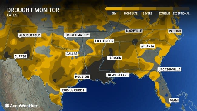
According to the latest U.S. Drought Monitor released on Tuesday, "exceptional" drought conditions, the worst level on a 4-point scale, were reported over far southeastern Texas into much of Louisiana and central and southern Mississippi. Not too far to the west, "extreme" drought was found over a portion of southern Texas from near Austin and San Antonio to the Gulf Coast.
 |
The drought in the region is both short and long term in nature. In Lake Charles, Louisiana, in the heart of the area with exceptional drought, the precipitation total is more than 17 inches below the historical average from the beginning of this year through Nov. 8 (34.79 inches observed versus the average amount of 52.07). Less than a quarter-inch of rain has fallen since the middle of October.
While the forecast rainfall into next week would not put the drought in Texas and western Louisiana to rest, it will go a long way in helping to alleviate the dry conditions. Farther north and east, the relief will be uneven and even more partial.
"The steadiest and heaviest rain will not fall across the portion of eastern Louisiana and Mississippi which are also in the most severe phase of drought," said Pydynowski. "However, the frontal passage will still bring some welcomed rain and cooler weather."
 |
That front can help to mix up the atmosphere there from Friday into the weekend, preventing occurrences of dense fog, as well as hopefully putting out some of the marsh fires occurring in Louisiana, explained Pydynowski.
On Tuesday, a deadly crash occurred along Interstate 10 in the eastern side of New Orleans amid "super fog," a combination of fog and smoke from the nearby marsh fires that led to near-zero visibility in the region. Another round of dense fog occurred in nearly the same region on Wednesday morning, leading officials to proactively close the interstate to prevent any further incidents, according to local TV station WVUE-TV.
Want next-level safety, ad-free? Unlock advanced, hyperlocal severe weather alerts when you subscribe to Premium+ on the AccuWeather app. AccuWeather Alerts™ are prompted by our expert meteorologists who monitor and analyze dangerous weather risks 24/7 to keep you and your family safer.
