Soaking rainstorm, interior ice and snow to impede weekend activities in northeastern US
A storm will continue to bring rain, fog, ice and a wintry mix to parts of the northeastern United States this weekend.
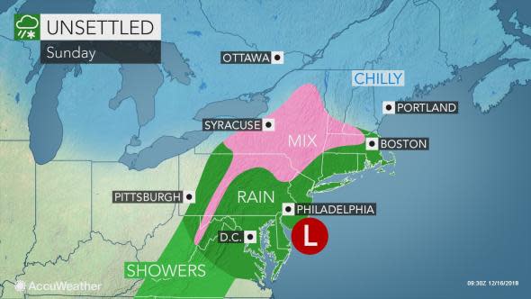
A general 1-2 inches of rain is forecast with locally higher amounts from the Ohio Valley to parts of the central Appalachians and the mid-Atlantic coast with lesser rain in store for parts of southern New England and upstate New York into Sunday.
While this rain will not cause flooding along small streams and rivers in general in the Northeast, enough rain will fall to slow travel with minor urban flooding likely.
Fog and a low cloud ceiling can trigger airline delays at the major hubs of Washington, D.C., Pittsburgh, Baltimore, Philadelphia, New York City and Newark, New Jersey. Some flight cancellations are possible at the smaller airports where fog blocks the view of the runway. Foggy episodes will also force some motorists to slow down.
On Sunday, rain and a wintry mix are likely to push northward across more of New York state and southern and central New England.
Motorists venturing along parts of I-81, I-86, I-87, I-88 and I-90 should remain vigilant for patches of ice and snow.
With temperatures forecast to hover near or just above the freezing mark in the wintry mix areas, roads that are treated with ice melting compounds should be primarily wet.
"Sunday is the most likely time for the wintry mix to reach the swath from Albany, New York, to Worcester, Massachusetts," AccuWeather Senior Meteorologist Brett Anderson said.
At the same time, periods of rain are likely to continue from Washington, D.C., and Baltimore to Philadelphia and New York City on Sunday. Any lingering light rain will gradually clear eastern Ohio and western Pennsylvania as the day progresses.
In between these areas, rain or lingering icy mix can change to wet snow in central Pennsylvania and the ridges in western Maryland and northern West Virginia on Sunday afternoon as colder air circulates in on the storm's backside.
A small, slushy accumulation is possible in the higher terrain.
As the mid-Atlantic dries out, the storm will spread snow or the wintry mix from northeastern Pennsylvania to Maine on Sunday night.
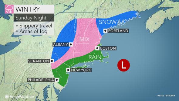
"There can be a stripe of 1-3 inches of snow that creates more slippery travel from western Massachusetts to southern Maine on Sunday night," AccuWeather Senior Meteorologist Kristina Pydynowski said.
Residents in Concord, New Hampshire, and Portland, Maine, should prepare for potential delays to school and travel for the Monday morning commute.
"The snow is currently is anticipated to remain north and west of New York City, Providence, Rhode Island, and Boston," according to Pydynowski.
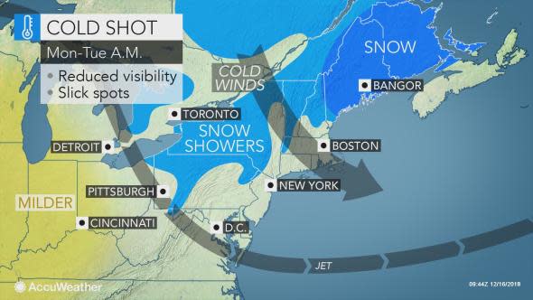
Disruptions may ramp up around Bangor, Maine, as the snow persists and continues to accumulate on Monday and Monday night.
Expect colder and blustery conditions over much of the Northeast on Monday with bands of lake-effect snow likely off Lake Erie and Lake Ontario.
"The lake-effect snow and steadier snow over Maine can wind down by Tuesday, but the cold winds can persist through this day," Pydynowski said. "Travelers will be happy to hear that calmer weather will grace the entire Northeast at midweek."
Download the free AccuWeather app to stay alert to your forecast and any weather advisories in your area.

TradeWx provides access to the CX weather market to allow you to trade the results of different weather events. Learn more on TradeWx.com.
