Cape Cod weather forecast: Here's what New England's weekend snowstorm will do on Cape Cod
A storm packing rain, wind and snow is headed for our region this weekend, but Cape Cod might avoid significant snow accumulation.
The big picture looks like this, according to the forecast discussion from the National Weather Service Boston/Norton office:
"A significant winter storm will impact the region Saturday night into Sunday, with heavy wet snow likely for much of the region. Dry weather Monday and likely lingers into most of Tuesday. Then a return of active weather Tuesday night into Wednesday, with the potential for a period of strong winds, heavy rain, and some river and stream flooding."
Joe Dellicarpini, a meteorologist at the National Weather Service Boston/Norton office, said Cape Codders might see a little snow as the storm reaches our area on Saturday, but rain will then take center stage.
The white stuff may return to the Cape on Sunday evening as the storm winds down. "You may see a little bit of snow," said Dellicarpini.
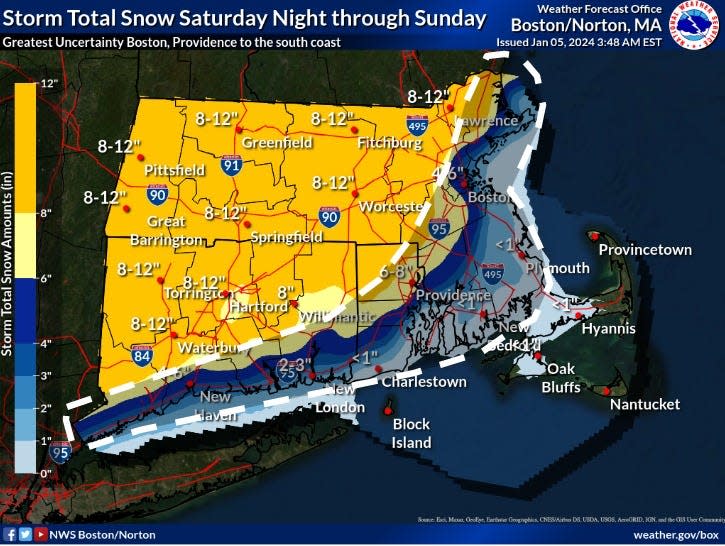
The rain/snow line will likely run close to Providence, R.I. up towards Plymouth, according to Dellicarpini. Locations to the west of that line are likely to see more snow.
During the Sunday evening time frame, the Hyannis forecast from the National Weather Service calls for possible snow accumulation of less than one inch.
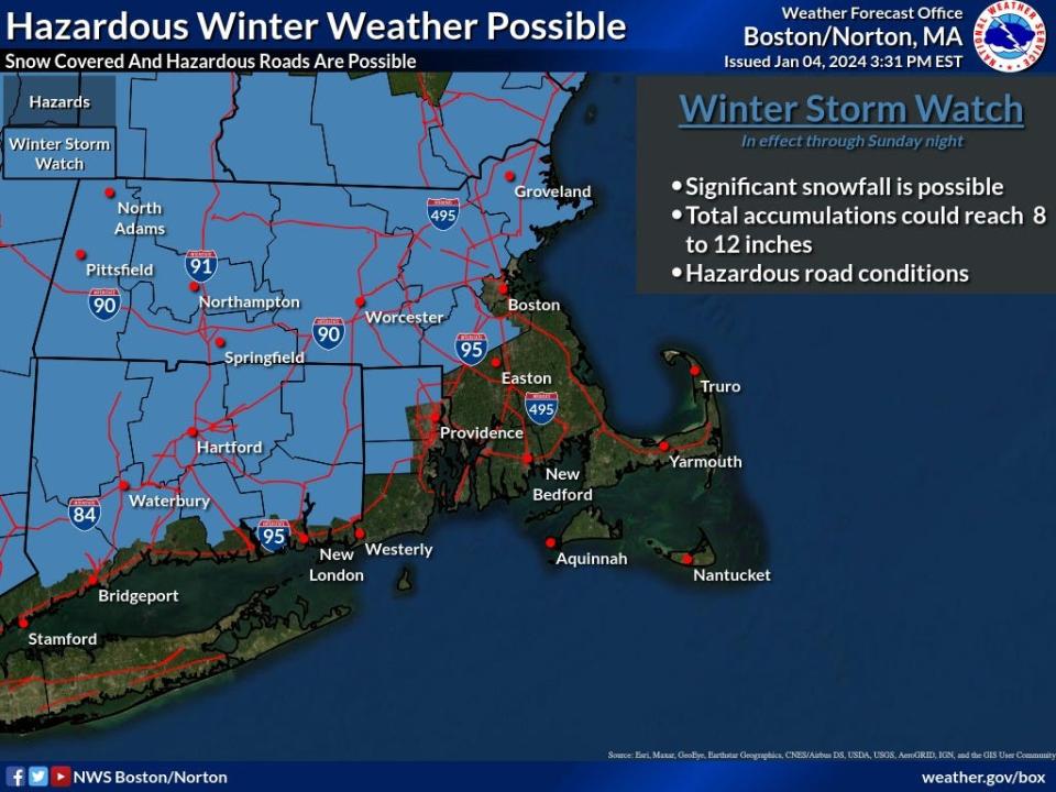
It will be a different weather story off-Cape, where some areas may see up to a foot of snow. A Winter Storm Watch is in effect for a good-sized swath of the state, as well as northern Connecticut and northern Rhode Island.
Dellicarpini said Cape drivers should expect icy and slick road conditions Sunday night into Monday morning, as temperatures drop into the 20s. Later in the day on Monday, rising temperatures should improve road conditions.
Wind is expected to be part of the weekend weather package, particularly on Sunday, when Cape Cod could see wind gusts over 40 mph.
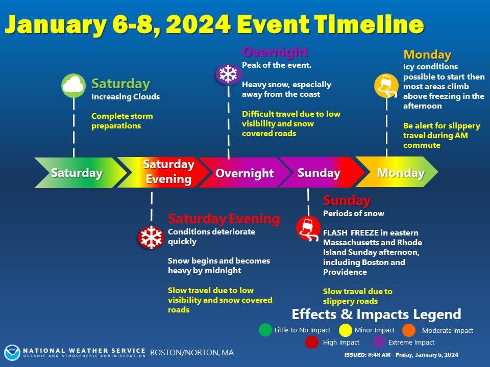
Lurking on the horizon is another storm event. During the Tuesday night into Wednesday time frame, there is the "potential for a period of strong winds, heavy rain, and some river and stream flooding," according to the National Weather Service forecast discussion.
Wind gusts could be in the 50 to 60 mph range on Cape Cod. On the bright side, temperatures will be too warm for snow to join the parade.
Here is the Hyannis forecast from the National Weather Service:
Saturday: Increasing clouds, with a high near 39. Northwest wind 5 to 7 mph becoming east in the afternoon.
Saturday night: Rain, possibly mixed with snow, becoming all rain after 1 a.m. Low around 32. Breezy, with an east wind 9 to 14 mph increasing to 19 to 24 mph after midnight. Winds could gust as high as 36 mph. Chance of precipitation is 100%. Little or no snow accumulation expected.
Sunday: Rain before 4 p.m., then snow, possibly mixed with rain. High near 40. Windy, with an east wind 29 to 32 mph, with gusts as high as 47 mph. Chance of precipitation is 100%. Little or no snow accumulation expected.
Sunday night: Snow likely, mainly before midnight. Mostly cloudy, with a low around 25. Windy, with a northwest wind 25 to 30 mph decreasing to 16 to 21 mph after midnight. Winds could gust as high as 45 mph. Chance of precipitation is 60%. New snow accumulation of less than one inch possible.
Monday: Mostly sunny, with a high near 36. Northwest wind 13 to 15 mph.
Tuesday: A chance of rain after 3 p.m. Mostly cloudy, with a high near 45. Northwest wind 8 to 13 mph becoming southeast in the afternoon. Chance of precipitation is 40%.
Tuesday night: Rain, mainly after 7 p.m. Low around 37. Windy, with a southeast wind 18 to 23 mph increasing to 29 to 34 mph after midnight. Winds could gust as high as 55 mph. Chance of precipitation is 90%.
Wednesday: Rain. The rain could be heavy at times. High near 52. Very windy, with a south wind 36 to 41 mph becoming southwest 29 to 34 mph in the afternoon. Winds could gust as high as 60 mph. Chance of precipitation is 100%.
Eric Williams, when not solving Curious Cape Cod mysteries, writes about a variety of ways to enjoy the Cape, the weather, wildlife and other subjects. Contact him at ewilliams@capecodonline.com. Follow him on X: @capecast.
The Cape Cod Times mobile app gets you to the heart of the matter — fast. Whether breaking news, sports, entertainment or weather get succinct, personalized coverage along with award-winning videos, captivating photography, and interactive user features. Download the app.
This article originally appeared on Cape Cod Times: Updated storm forecast: Will it snow on Cape Cod this weekend?

